- Home
- :
- All Communities
- :
- Products
- :
- ArcGIS Aviation
- :
- ArcGIS Aviation Questions
- :
- Aviation, Creating Curved Approach OIS Workflow an...
- Subscribe to RSS Feed
- Mark Topic as New
- Mark Topic as Read
- Float this Topic for Current User
- Bookmark
- Subscribe
- Mute
- Printer Friendly Page
Aviation, Creating Curved Approach OIS Workflow and Example Use of CustomizeOIS.exe
- Mark as New
- Bookmark
- Subscribe
- Mute
- Subscribe to RSS Feed
- Permalink
- Report Inappropriate Content
Just working on creating OIS surface for a curved approach path and not something I have tried before in ArcGIS Aviation. I have outlined the description of the flight OIS below and just want to understand the workflow of using a customizeOIS.exe to create this. Have been working through Creating curved approach obstruction identification surfaces—ArcMap | Documentation (arcgis.com) but still not sure on the workflow.
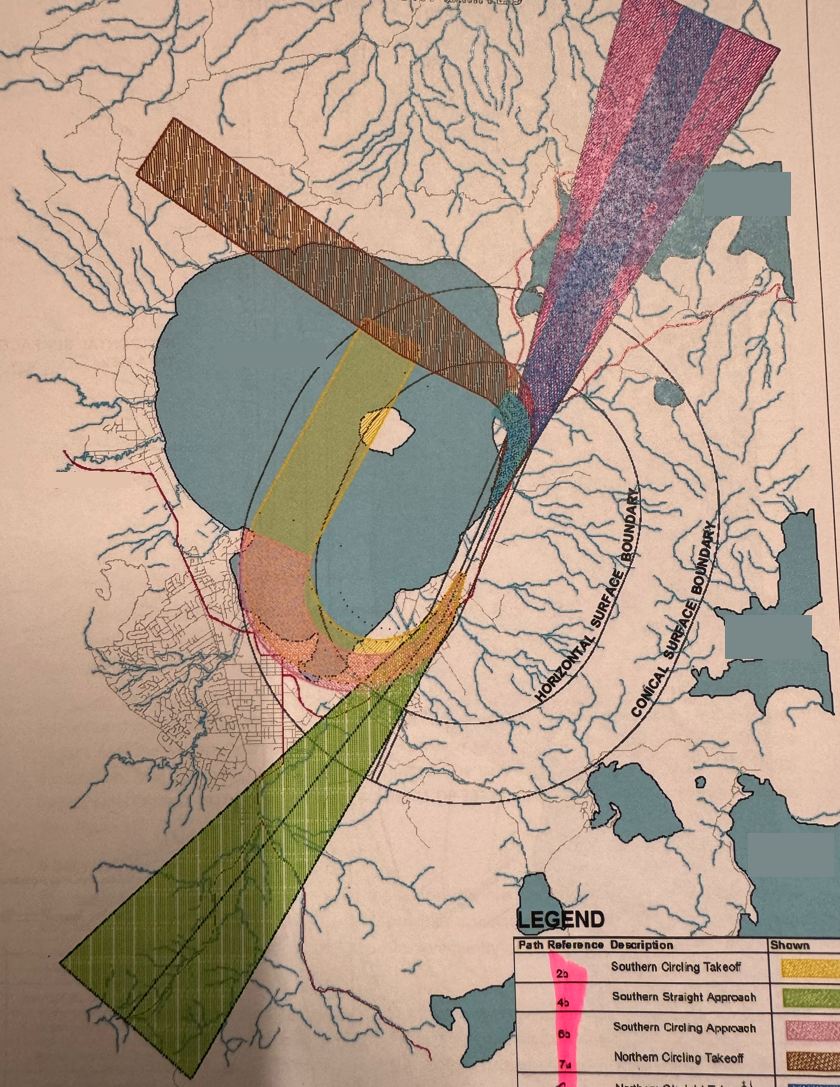
Example: Description of Curved OIS (see picture attached)
Curved Approach (Figure 3 path 6b) - shown in image attached as pink shading at southern end of runway
The curved approach surface from the south commences at the inner edge and rises at a gradient of 2.5% (1:40) over a horizontal distance of 9,109m, extending to the edge of the lake shore. The surface edges diverge from each end of the inner edge at a rate of 10% (1:10) to a final width of 1,972m.
The surface centreline follows the extended runway centreline to a point 1,318m from the inner edge. At this point the surface centreline commences a right turn of radius 2,480m through an arc of 180 degrees.
Thanks in advance for any help.
- Mark as New
- Bookmark
- Subscribe
- Mute
- Subscribe to RSS Feed
- Permalink
- Report Inappropriate Content
Hi David,
Just to be sure, if you are looking into CustomizeOIS.exe, then you're going to be using Pro (not ArcMap). And for a curved approach, use the 'Create Curved Approach' tool in the Pro Aviation toolbox.
It looks like you may be using the ICAO Annex 14 specification? In CustomizeOIS.exe, you would edit and save out a custom JSON after editing some Approach surface parameters for your Specification and runway classification. For ICAO Annex 14, you can edit the value for 'Divergence' based on "edges diverge from each end of the inner edge at a rate of 10%" in your description. Edit 'First Section Length' based on a "horizontal distance of 9,109m" and edit 'First Section Slope' based on "rises at a gradient of 2.5% (1:40)". Some of the default values may already match what you need.
Beyond that, you will need to create a flight path polyline feature class to use for the tool's parameter , Input Flight Path Features | The polyline features that define curved approaches to the specified runways, terminating at the runway centerline endpoint.
You would need to construct its geometry based on your description "The surface centreline follows the extended runway centreline to a point 1,318m from the inner edge. At this point the surface centreline commences a right turn of radius 2,480m through an arc of 180 degrees."
The Distance and Direction tools, opened from the Insert ribbon in Pro may help with creating the flight path feature.
I hope this helps!
- Mark as New
- Bookmark
- Subscribe
- Mute
- Subscribe to RSS Feed
- Permalink
- Report Inappropriate Content
Hi David,
Thanks for your post. It helped a lot.
I'm using ArcPro curved approach tool with a JSON file configuration created with CustomizeOIS.exe to create a Take Off Climb Surface.
The description for the surface: shown in image attached to David Herries (my colleague) post as yellow shading at southern end of runway
The southern take-off OLS commences at the south end inner edge and rises at a gradient of 2.0% (1:50) over a horizontal distance of 15,000m. The surface edges commence at each end of the inner edge, located 90m either side of the runway centreline.
The surface edges diverge from each end of the inner edge at a rate of 12.5% (1:8) to a final width of 1,800m (900m either side of the surface centreline).
Using the CustomizeOIS.exe I added in the final width of 1800 but the result ignores the final width property. I tried creating the surface with the final width value set to 0 to see if it gives a different outcome, but still the same result. The surface edge is also not according to the properties specified from the properties settings. It measures 140m instead of 90m on either side of the runway centreline.
See my result attached. (surface edge.png, Surface width at end.png, Take off surface.png)
the yellow area is just an approximate measure of what the surface should look like (width at start and end) and the grey area is the result from running the curved approach tool using the JSON configuration file.


Do you have any idea on how to make this work. I have 2 surfaces that are almost similar just going in different directions.
Thanks in advance for any help.
- Mark as New
- Bookmark
- Subscribe
- Mute
- Subscribe to RSS Feed
- Permalink
- Report Inappropriate Content
Hi Katie,
I am sorry but I think this will require more evaluation. Please put in an Esri Support case request.
Thanks,
David