Turn on suggestions
Auto-suggest helps you quickly narrow down your search results by suggesting possible matches as you type.
Cancel
- Home
- :
- All Communities
- :
- Developers
- :
- ArcGIS API Silverlight (Retired)
- :
- ArcGIS API Silverlight Questions
- :
- System.Runtime.Serialization Version????
Options
- Subscribe to RSS Feed
- Mark Topic as New
- Mark Topic as Read
- Float this Topic for Current User
- Bookmark
- Subscribe
- Mute
- Printer Friendly Page
System.Runtime.Serialization Version????
Subscribe
8442
10
04-09-2010 12:44 PM
04-09-2010
12:44 PM
- Mark as New
- Bookmark
- Subscribe
- Mute
- Subscribe to RSS Feed
- Permalink
I was able to get a simple ArcGIS silverlight app up and running. I then tried to use the sample identify that ESRI posted as part of their SL sample site. I am using ArcGIS Silverlight SDK 1.2 along with SL3 and SDK3. The error applies when ever I post the following in my code:
<esriSymbols:PictureMarkerSymbol x:Name="DefaultPictureSymbol" OffsetX="35" OffsetY="35"
Source="/Images/i_about.png" />
Error:
The "ValidateXaml" task failed unexpectedly.
System.IO.FileNotFoundException: Could not load file or assembly 'System.Runtime.Serialization, Version=2.0.5.0, Culture=neutral, PublicKeyToken=7cec85d7bea7798e' or one of its dependencies. The system cannot find the file specified.
File name: 'System.Runtime.Serialization, Version=2.0.5.0, Culture=neutral, PublicKeyToken=7cec85d7bea7798e'
The version of 'System.Runtime.Serialization' that SL3 installed is 3.0.50106
What am I mising? Are the samples out of dates? SL4 installed version 4.0...
Thanks
10 Replies
04-09-2010
01:40 PM
- Mark as New
- Bookmark
- Subscribe
- Mute
- Subscribe to RSS Feed
- Permalink
Simply add a reference to System.Runtime.Serialization
04-12-2010
08:01 AM
- Mark as New
- Bookmark
- Subscribe
- Mute
- Subscribe to RSS Feed
- Permalink
It worked. Thanks!
12-21-2010
06:26 AM
- Mark as New
- Bookmark
- Subscribe
- Mute
- Subscribe to RSS Feed
- Permalink
Hey guys... i know it has been a while since this post was created but i am having the same issue. where is the dll hidden so that i may reference it.
08-06-2011
09:25 PM
- Mark as New
- Bookmark
- Subscribe
- Mute
- Subscribe to RSS Feed
- Permalink
Hello,
I ran into the same issue (working on the GeoRSS sample http://help.arcgis.com/EN/webapi/silverlight/samples/start.htm#GeoRSS).
After adding the system.runtime.serilization reference, it solved that error. However, I also received other errors:
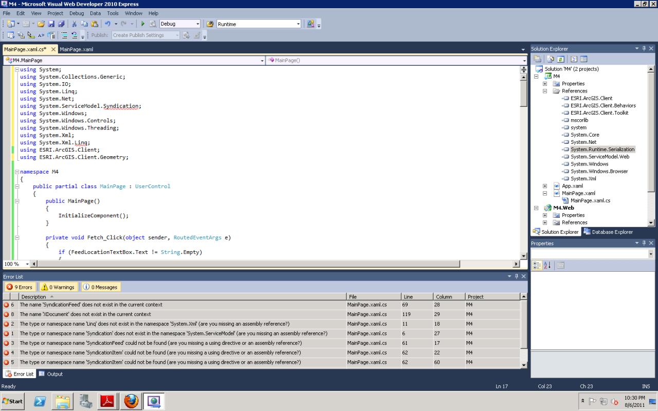
Error 6 The name 'SyndicationFeed' does not exist in the current context C:\Student\CEWA\M4\M4\MainPage.xaml.cs 69 28 M4
Error 8 The name 'XDocument' does not exist in the current context C:\Student\CEWA\M4\M4\MainPage.xaml.cs 119 29 M4
Error 2 The type or namespace name 'Linq' does not exist in the namespace 'System.Xml' (are you missing an assembly reference?) C:\Student\CEWA\M4\M4\MainPage.xaml.cs 11 18 M4
Error 1 The type or namespace name 'Syndication' does not exist in the namespace 'System.ServiceModel' (are you missing an assembly reference?) C:\Student\CEWA\M4\M4\MainPage.xaml.cs 6 27 M4
Error 3 The type or namespace name 'SyndicationFeed' could not be found (are you missing a using directive or an assembly reference?) C:\Student\CEWA\M4\M4\MainPage.xaml.cs 61 17 M4
Error 4 The type or namespace name 'SyndicationItem' could not be found (are you missing a using directive or an assembly reference?) C:\Student\CEWA\M4\M4\MainPage.xaml.cs 62 22 M4
Error 5 The type or namespace name 'SyndicationItem' could not be found (are you missing a using directive or an assembly reference?) C:\Student\CEWA\M4\M4\MainPage.xaml.cs 62 60 M4
Error 7 The type or namespace name 'XDocument' could not be found (are you missing a using directive or an assembly reference?) C:\Student\CEWA\M4\M4\MainPage.xaml.cs 119 13 M4
Error 9 The type or namespace name 'XNamespace' could not be found (are you missing a using directive or an assembly reference?) C:\Student\CEWA\M4\M4\MainPage.xaml.cs 120 13 M4
Note: I am trying to use the sample code from - http://help.arcgis.com/EN/webapi/silverlight/samples/start.htm#GeoRSS
Here are 2 screenshots attached:
Any guidance or words of wisdom on how to proceed to get this sample to work will be greatly appreciated! My final project, which involves incorporate GeoRSS Feed(s) is due in less than 48 hours 😞
Thank You!!
I ran into the same issue (working on the GeoRSS sample http://help.arcgis.com/EN/webapi/silverlight/samples/start.htm#GeoRSS).
After adding the system.runtime.serilization reference, it solved that error. However, I also received other errors:
Error 6 The name 'SyndicationFeed' does not exist in the current context C:\Student\CEWA\M4\M4\MainPage.xaml.cs 69 28 M4
Error 8 The name 'XDocument' does not exist in the current context C:\Student\CEWA\M4\M4\MainPage.xaml.cs 119 29 M4
Error 2 The type or namespace name 'Linq' does not exist in the namespace 'System.Xml' (are you missing an assembly reference?) C:\Student\CEWA\M4\M4\MainPage.xaml.cs 11 18 M4
Error 1 The type or namespace name 'Syndication' does not exist in the namespace 'System.ServiceModel' (are you missing an assembly reference?) C:\Student\CEWA\M4\M4\MainPage.xaml.cs 6 27 M4
Error 3 The type or namespace name 'SyndicationFeed' could not be found (are you missing a using directive or an assembly reference?) C:\Student\CEWA\M4\M4\MainPage.xaml.cs 61 17 M4
Error 4 The type or namespace name 'SyndicationItem' could not be found (are you missing a using directive or an assembly reference?) C:\Student\CEWA\M4\M4\MainPage.xaml.cs 62 22 M4
Error 5 The type or namespace name 'SyndicationItem' could not be found (are you missing a using directive or an assembly reference?) C:\Student\CEWA\M4\M4\MainPage.xaml.cs 62 60 M4
Error 7 The type or namespace name 'XDocument' could not be found (are you missing a using directive or an assembly reference?) C:\Student\CEWA\M4\M4\MainPage.xaml.cs 119 13 M4
Error 9 The type or namespace name 'XNamespace' could not be found (are you missing a using directive or an assembly reference?) C:\Student\CEWA\M4\M4\MainPage.xaml.cs 120 13 M4
Note: I am trying to use the sample code from - http://help.arcgis.com/EN/webapi/silverlight/samples/start.htm#GeoRSS
Here are 2 screenshots attached:
Any guidance or words of wisdom on how to proceed to get this sample to work will be greatly appreciated! My final project, which involves incorporate GeoRSS Feed(s) is due in less than 48 hours 😞
Thank You!!
08-07-2011
03:29 AM
- Mark as New
- Bookmark
- Subscribe
- Mute
- Subscribe to RSS Feed
- Permalink
Just Goggle the class it cannot resolve then chose the MSDN link. On the MSDN page, chose the Silverlight version and it will give you everthing you need:
http://msdn.microsoft.com/en-us/library/system.servicemodel.syndication.syndicationfeed(v=VS.95).asp...
http://msdn.microsoft.com/en-us/library/system.servicemodel.syndication.syndicationfeed(v=VS.95).asp...
08-07-2011
12:37 PM
- Mark as New
- Bookmark
- Subscribe
- Mute
- Subscribe to RSS Feed
- Permalink
Thank you so much!! It's working now. I had to add a few references (i.e. system.ServiceModel.Syndication)
Edit:
I was able to publish the map onto my server, and everything looks fantastic! Except for one item: I can't get the feed for some reason....
When I tried to fetch a feed within my published map, nothing happens or I receive the error message. On the other hand, when I used the same feed (http://earthquake.usgs.gov/eqcenter/catalogs/eqs7day-M2.5.xml) or a different feed within the sample map (http://help.arcgis.com/EN/webapi/silverlight/samples/start.htm#GeoRSS), it was able to fetch the feed.
I'm not sure what's wrong with my code? I was able to debug and publish my map.
Here's my code:
using System;
using System.Collections.Generic;
using System.IO;
using System.Linq;
using System.Net;
using System.ServiceModel.Syndication;
using System.Windows;
using System.Windows.Controls;
using System.Windows.Threading;
using System.Xml;
using System.Xml.Linq;
using ESRI.ArcGIS.Client;
using ESRI.ArcGIS.Client.Geometry;
namespace M4
{
public partial class MainPage : UserControl
{
public MainPage()
{
InitializeComponent();
}
private void Fetch_Click(object sender, RoutedEventArgs e)
{
if (FeedLocationTextBox.Text != String.Empty)
{
LoadRSS(FeedLocationTextBox.Text.Trim());
DispatcherTimer UpdateTimer = new System.Windows.Threading.DispatcherTimer();
UpdateTimer.Interval = new TimeSpan(0, 0, 0, 0, 60000);
UpdateTimer.Tick += (evtsender, args) =>
{
LoadRSS(FeedLocationTextBox.Text.Trim());
};
UpdateTimer.Start();
}
}
protected void LoadRSS(string uri)
{
WebClient wc = new WebClient();
wc.OpenReadCompleted += wc_OpenReadCompleted;
Uri feedUri = new Uri(uri, UriKind.Absolute);
wc.OpenReadAsync(feedUri);
}
private void wc_OpenReadCompleted(object sender, OpenReadCompletedEventArgs e)
{
if (e.Error != null)
{
FeedLocationTextBox.Text = "Error in Reading Feed. Try Again later!!";
return;
}
// Optional, use LINQ to query GeoRSS feed.
//UseLinq(e.Result); return;
using (Stream s = e.Result)
{
SyndicationFeed feed;
List<SyndicationItem> feedItems = new List<SyndicationItem>();
GraphicsLayer graphicsLayer = MyMap.Layers["MyGraphicsLayer"] as GraphicsLayer;
graphicsLayer.ClearGraphics();
using (XmlReader reader = XmlReader.Create(s))
{
feed = SyndicationFeed.Load(reader);
foreach (SyndicationItem feedItem in feed.Items)
{
SyndicationElementExtensionCollection ec = feedItem.ElementExtensions;
string x = "";
string y = "";
string magnitude = feedItem.Title.Text;
foreach (SyndicationElementExtension ee in ec)
{
XmlReader xr = ee.GetReader();
switch (ee.OuterName)
{
case ("lat"):
{
y = xr.ReadElementContentAsString();
break;
}
case ("long"):
{
x = xr.ReadElementContentAsString();
break;
}
}
}
if (!string.IsNullOrEmpty(x))
{
Graphic graphic = new Graphic()
{
Geometry = new MapPoint(Convert.ToDouble(x, System.Globalization.CultureInfo.InvariantCulture),
Convert.ToDouble(y, System.Globalization.CultureInfo.InvariantCulture)),
Symbol = LayoutRoot.Resources["QuakePictureSymbol"] as ESRI.ArcGIS.Client.Symbols.Symbol
};
graphic.Attributes.Add("MAGNITUDE", magnitude);
graphicsLayer.Graphics.Add(graphic);
}
}
}
}
}
private void UseLinq(Stream s)
{
GraphicsLayer graphicsLayer = MyMap.Layers["MyGraphicsLayer"] as GraphicsLayer;
graphicsLayer.ClearGraphics();
XDocument doc = XDocument.Load(s);
XNamespace geo = "http://www.w3.org/2003/01/geo/wgs84_pos#";
var rssGraphics = from rssgraphic in doc.Descendants("item")
select new RssGraphic
{
Geometry = new MapPoint(
Convert.ToDouble(rssgraphic.Element(geo + "long").Value, System.Globalization.CultureInfo.InvariantCulture),
Convert.ToDouble(rssgraphic.Element(geo + "lat").Value, System.Globalization.CultureInfo.InvariantCulture)),
Symbol = LayoutRoot.Resources["QuakePictureSymbol"] as ESRI.ArcGIS.Client.Symbols.Symbol,
RssAttributes = new Dictionary<string, object>() { { "MAGNITUDE", rssgraphic.Element("title").Value } }
};
foreach (RssGraphic rssGraphic in rssGraphics)
{
foreach (KeyValuePair<string, object> rssAttribute in rssGraphic.RssAttributes)
{
rssGraphic.Attributes.Add(rssAttribute.Key, rssAttribute.Value);
}
graphicsLayer.Graphics.Add((Graphic)rssGraphic);
}
}
internal class RssGraphic : Graphic
{
public Dictionary<string, object> RssAttributes { get; set; }
}
}
}
08-07-2011
01:08 PM
- Mark as New
- Bookmark
- Subscribe
- Mute
- Subscribe to RSS Feed
- Permalink
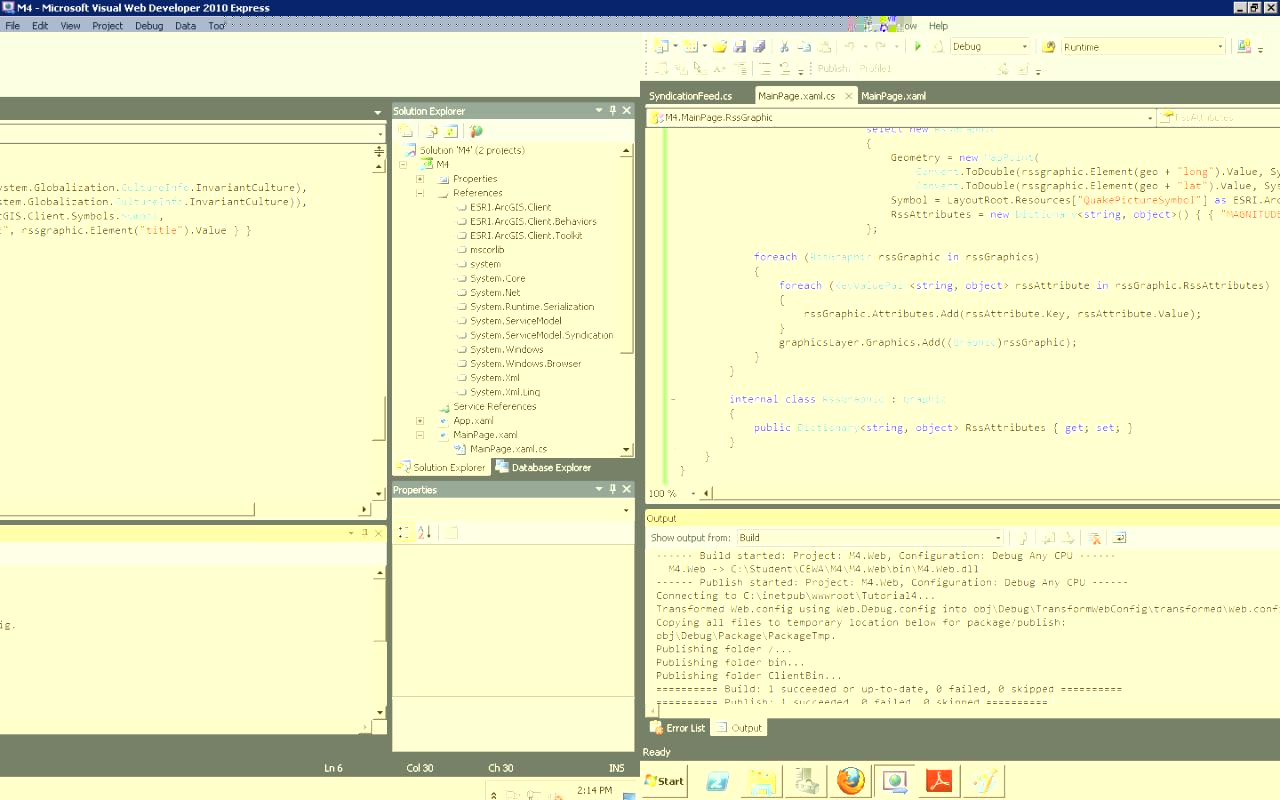
Here's a screen shot
*Almost got this to work* Crossing my fingers...
*Almost got this to work* Crossing my fingers...
Thank you so much!! It's working now. I had to add a few references (i.e. system.ServiceModel.Syndication)
Edit:
I was able to publish the map onto my server, and everything looks fantastic! Except for one item: I can't get the feed for some reason....
When I tried to fetch a feed within my published map, nothing happens or I receive the error message. On the other hand, when I used the same feed (http://earthquake.usgs.gov/eqcenter/catalogs/eqs7day-M2.5.xml) or a different feed within the sample map (http://help.arcgis.com/EN/webapi/silverlight/samples/start.htm#GeoRSS), it was able to fetch the feed.
I'm not sure what's wrong with my code? I was able to debug and publish my map.
Here's my code:
using System;
using System.Collections.Generic;
using System.IO;
using System.Linq;
using System.Net;
using System.ServiceModel.Syndication;
using System.Windows;
using System.Windows.Controls;
using System.Windows.Threading;
using System.Xml;
using System.Xml.Linq;
using ESRI.ArcGIS.Client;
using ESRI.ArcGIS.Client.Geometry;
namespace M4
{
public partial class MainPage : UserControl
{
public MainPage()
{
InitializeComponent();
}
private void Fetch_Click(object sender, RoutedEventArgs e)
{
if (FeedLocationTextBox.Text != String.Empty)
{
LoadRSS(FeedLocationTextBox.Text.Trim());
DispatcherTimer UpdateTimer = new System.Windows.Threading.DispatcherTimer();
UpdateTimer.Interval = new TimeSpan(0, 0, 0, 0, 60000);
UpdateTimer.Tick += (evtsender, args) =>
{
LoadRSS(FeedLocationTextBox.Text.Trim());
};
UpdateTimer.Start();
}
}
protected void LoadRSS(string uri)
{
WebClient wc = new WebClient();
wc.OpenReadCompleted += wc_OpenReadCompleted;
Uri feedUri = new Uri(uri, UriKind.Absolute);
wc.OpenReadAsync(feedUri);
}
private void wc_OpenReadCompleted(object sender, OpenReadCompletedEventArgs e)
{
if (e.Error != null)
{
FeedLocationTextBox.Text = "Error in Reading Feed. Try Again later!!";
return;
}
// Optional, use LINQ to query GeoRSS feed.
//UseLinq(e.Result); return;
using (Stream s = e.Result)
{
SyndicationFeed feed;
List<SyndicationItem> feedItems = new List<SyndicationItem>();
GraphicsLayer graphicsLayer = MyMap.Layers["MyGraphicsLayer"] as GraphicsLayer;
graphicsLayer.ClearGraphics();
using (XmlReader reader = XmlReader.Create(s))
{
feed = SyndicationFeed.Load(reader);
foreach (SyndicationItem feedItem in feed.Items)
{
SyndicationElementExtensionCollection ec = feedItem.ElementExtensions;
string x = "";
string y = "";
string magnitude = feedItem.Title.Text;
foreach (SyndicationElementExtension ee in ec)
{
XmlReader xr = ee.GetReader();
switch (ee.OuterName)
{
case ("lat"):
{
y = xr.ReadElementContentAsString();
break;
}
case ("long"):
{
x = xr.ReadElementContentAsString();
break;
}
}
}
if (!string.IsNullOrEmpty(x))
{
Graphic graphic = new Graphic()
{
Geometry = new MapPoint(Convert.ToDouble(x, System.Globalization.CultureInfo.InvariantCulture),
Convert.ToDouble(y, System.Globalization.CultureInfo.InvariantCulture)),
Symbol = LayoutRoot.Resources["QuakePictureSymbol"] as ESRI.ArcGIS.Client.Symbols.Symbol
};
graphic.Attributes.Add("MAGNITUDE", magnitude);
graphicsLayer.Graphics.Add(graphic);
}
}
}
}
}
private void UseLinq(Stream s)
{
GraphicsLayer graphicsLayer = MyMap.Layers["MyGraphicsLayer"] as GraphicsLayer;
graphicsLayer.ClearGraphics();
XDocument doc = XDocument.Load(s);
XNamespace geo = "http://www.w3.org/2003/01/geo/wgs84_pos#";
var rssGraphics = from rssgraphic in doc.Descendants("item")
select new RssGraphic
{
Geometry = new MapPoint(
Convert.ToDouble(rssgraphic.Element(geo + "long").Value, System.Globalization.CultureInfo.InvariantCulture),
Convert.ToDouble(rssgraphic.Element(geo + "lat").Value, System.Globalization.CultureInfo.InvariantCulture)),
Symbol = LayoutRoot.Resources["QuakePictureSymbol"] as ESRI.ArcGIS.Client.Symbols.Symbol,
RssAttributes = new Dictionary<string, object>() { { "MAGNITUDE", rssgraphic.Element("title").Value } }
};
foreach (RssGraphic rssGraphic in rssGraphics)
{
foreach (KeyValuePair<string, object> rssAttribute in rssGraphic.RssAttributes)
{
rssGraphic.Attributes.Add(rssAttribute.Key, rssAttribute.Value);
}
graphicsLayer.Graphics.Add((Graphic)rssGraphic);
}
}
internal class RssGraphic : Graphic
{
public Dictionary<string, object> RssAttributes { get; set; }
}
}
}
08-07-2011
04:29 PM
- Mark as New
- Bookmark
- Subscribe
- Mute
- Subscribe to RSS Feed
- Permalink
I am guessing that this might relate to client access policy:
http://help.arcgis.com/en/webapi/silverlight/help/index.html#//016600000009000000.htm
http://help.arcgis.com/en/webapi/silverlight/help/index.html#//016600000009000000.htm