Turn on suggestions
Auto-suggest helps you quickly narrow down your search results by suggesting possible matches as you type.
Cancel
- Home
- :
- All Communities
- :
- Developers
- :
- ArcGIS API Silverlight (Retired)
- :
- ArcGIS API Silverlight Questions
- :
- Polygon point relation problem. Help!
Options
- Subscribe to RSS Feed
- Mark Topic as New
- Mark Topic as Read
- Float this Topic for Current User
- Bookmark
- Subscribe
- Mute
- Printer Friendly Page
Polygon point relation problem. Help!
Subscribe
5259
5
02-07-2011 08:46 AM
02-07-2011
08:46 AM
- Mark as New
- Bookmark
- Subscribe
- Mute
- Subscribe to RSS Feed
- Permalink
Hi,
I'm just asking about this problem because I can't think of anything else.
Let me explain.
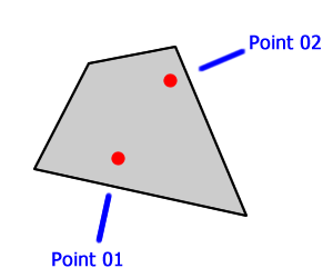
I have a map with 2 layers, polygons and points, just like attached picture 01.
What I need to do is to display a line and a text to identify each point inside a polygon, just like picture 02.
The problem is that I need to know in which direction and angle I should draw the line and the text. They must be drawn in the nearest outside region of the polygon.
That's why I can't make it work.
I tried to scan the region near to the point using the circle equation and rising the radius to find the nearest point in the outside region (x = a * r + cos t, y = b * r + sin t) and it works (picture 03), but takes too long (a LOT of steps in loop) to consult the server using RelationWithin.
Maybe there is a way to do all the consult stuff on the server side... Or a fastest way to do that...
I really need help here.
Thanks a lot.
I'm just asking about this problem because I can't think of anything else.
Let me explain.
I have a map with 2 layers, polygons and points, just like attached picture 01.
What I need to do is to display a line and a text to identify each point inside a polygon, just like picture 02.
The problem is that I need to know in which direction and angle I should draw the line and the text. They must be drawn in the nearest outside region of the polygon.
That's why I can't make it work.
I tried to scan the region near to the point using the circle equation and rising the radius to find the nearest point in the outside region (x = a * r + cos t, y = b * r + sin t) and it works (picture 03), but takes too long (a LOT of steps in loop) to consult the server using RelationWithin.
Maybe there is a way to do all the consult stuff on the server side... Or a fastest way to do that...
I really need help here.
Thanks a lot.
5 Replies
by
Anonymous User
Not applicable
02-07-2011
09:44 AM
- Mark as New
- Bookmark
- Subscribe
- Mute
- Subscribe to RSS Feed
- Permalink
Original User: danwallie
If you're safe in assuming that your polygons are simple (in the trigonometric sense), you could do it all in the client using a simple PointInPolygon routine (see this post). You could simplify the search pattern by only testing points N,E,W,S of the original point (which would mean your leader lines would be horizontal or vertical only), and stop as soon as you find a point outside the polygon, and use that point as the first line vertex, and you can easily extrapolate the second vertex and annotation position. This would be much faster than doing a bunch of server roundtrips.
If you're safe in assuming that your polygons are simple (in the trigonometric sense), you could do it all in the client using a simple PointInPolygon routine (see this post). You could simplify the search pattern by only testing points N,E,W,S of the original point (which would mean your leader lines would be horizontal or vertical only), and stop as soon as you find a point outside the polygon, and use that point as the first line vertex, and you can easily extrapolate the second vertex and annotation position. This would be much faster than doing a bunch of server roundtrips.
by
Anonymous User
Not applicable
02-07-2011
10:09 AM
- Mark as New
- Bookmark
- Subscribe
- Mute
- Subscribe to RSS Feed
- Permalink
Original User: danwallie
All those polygons in the pictures are geometrically simple. I still think its doable even if you sample along, say, 30 degree steps.
All those polygons in the pictures are geometrically simple. I still think its doable even if you sample along, say, 30 degree steps.
02-07-2011
10:31 AM
- Mark as New
- Bookmark
- Subscribe
- Mute
- Subscribe to RSS Feed
- Permalink
I see what you meant Daniel. I will try that and let you know if it worked.
Thanks again.
Thanks again.
by
Anonymous User
Not applicable
02-09-2011
10:06 AM
- Mark as New
- Bookmark
- Subscribe
- Mute
- Subscribe to RSS Feed
- Permalink
Original User: sdantas
Thanks a lot Daniel. I changed the code to work on client with the method you gave and it's working like a charm.
Thanks a lot Daniel. I changed the code to work on client with the method you gave and it's working like a charm.