Turn on suggestions
Auto-suggest helps you quickly narrow down your search results by suggesting possible matches as you type.
Cancel
- Home
- :
- All Communities
- :
- Developers
- :
- ArcGIS API for Flex (Retired)
- :
- ArcGIS API for Flex Questions
- :
- How can we clear the map contents
Options
- Subscribe to RSS Feed
- Mark Topic as New
- Mark Topic as Read
- Float this Topic for Current User
- Bookmark
- Subscribe
- Mute
- Printer Friendly Page
How can we clear the map contents
Subscribe
2243
5
03-07-2012 10:54 PM
03-07-2012
10:54 PM
- Mark as New
- Bookmark
- Subscribe
- Mute
- Subscribe to RSS Feed
- Permalink
hi
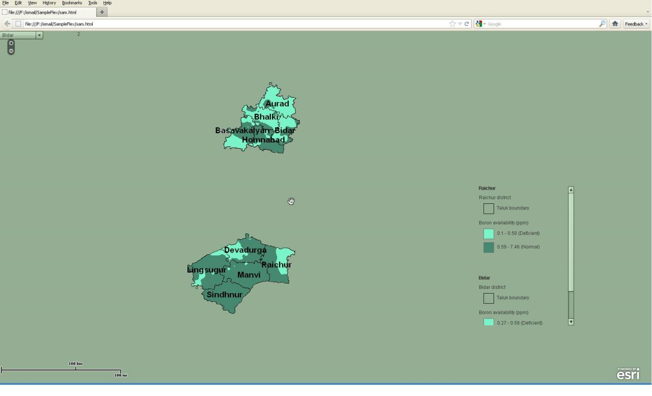
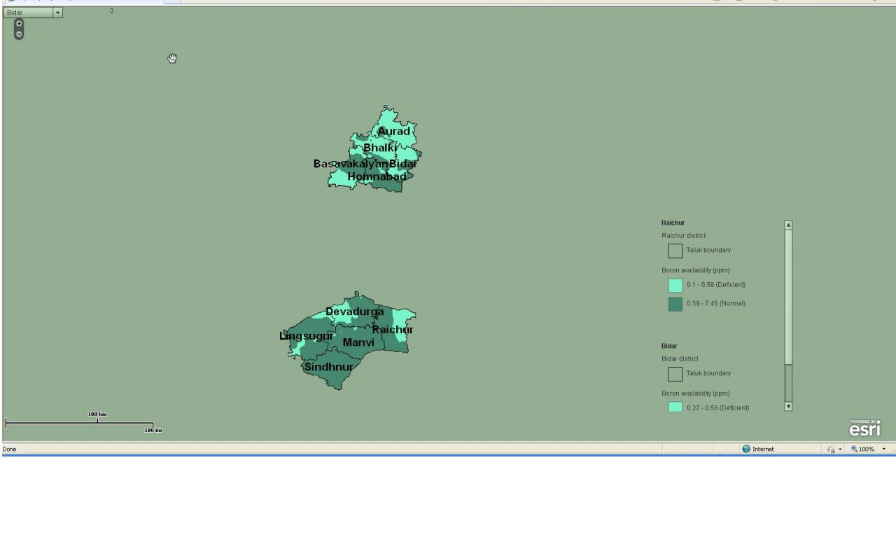
i was trying to clear the map object so that at a time only one service should be visible and same should reflect in the legend
but i am unable to do that
as you can see in the screen shot i have attached
Thanks & regards
ISmail
i was trying to clear the map object so that at a time only one service should be visible and same should reflect in the legend
but i am unable to do that
as you can see in the screen shot i have attached
Thanks & regards
ISmail
5 Replies
03-07-2012
11:31 PM
- Mark as New
- Bookmark
- Subscribe
- Mute
- Subscribe to RSS Feed
- Permalink
Take a look to first sample in this post http://forums.arcgis.com/threads/48905-Legend-component-rendering-issue?p=169901#post169901.
03-15-2012
09:55 PM
- Mark as New
- Bookmark
- Subscribe
- Mute
- Subscribe to RSS Feed
- Permalink
hi
i have added the highligted code to LEgendSkin skin class file (com.esri.ags.skins.LegendSkin) but it makes no difference to the legend
and i tried commenting few lines in the legendskin class file
// exclude Spacer if sublayer is not visible
if (serviceGroups.getElementAt(e) is mx.controls.Spacer)
{
if (isSubLayerVisible)
{
mx.controls.Spacer(serviceGroups.getElementAt(e)).visible = mx.controls.Spacer(serviceGroups.getElementAt(e)).includeInLayout = true;
if (!subLayerInScaleRange(leafLayerLegendInfo))
{
if (hostComponent.respectCurrentMapScale)
{
mx.controls.Spacer(serviceGroups.getElementAt(e)).visible = mx.controls.Spacer(serviceGroups.getElementAt(e)).includeInLayout = false;
}
}
}
else
{
mx.controls.Spacer(serviceGroups.getElementAt(e)).visible = mx.controls.Spacer(serviceGroups.getElementAt(e)).includeInLayout = false;
}
}
what could be the reason if u can tell me it will be great help
thanks
ismail
03-15-2012
10:19 PM
- Mark as New
- Bookmark
- Subscribe
- Mute
- Subscribe to RSS Feed
- Permalink
Legend for 2 standalone layers. (code) - only selected service visible in Legend component.
Show your code. (it's easyest way to find bugs in your code)
Show your code. (it's easyest way to find bugs in your code)
03-18-2012
09:25 PM
- Mark as New
- Bookmark
- Subscribe
- Mute
- Subscribe to RSS Feed
- Permalink
hi
Below is the code , pls tell me
1. i want to clear map i.e. is should display only one service at a time
2. Legend should show only one service layers
Thanls
<?xml version="1.0" encoding="utf-8"?>
<s:Application xmlns:fx="http://ns.adobe.com/mxml/2009"
xmlns:s="library://ns.adobe.com/flex/spark"
xmlns:mx="library://ns.adobe.com/flex/mx"
xmlns:esri="http://www.esri.com/2008/ags">
<fx:Script>
<![CDATA[
import com.esri.ags.events.LayerEvent;
import com.esri.ags.geometry.MapPoint;
import com.esri.ags.layers.ArcGISDynamicMapServiceLayer;
import mx.charts.chartClasses.LegendData;
[Bindable] private var layerCount:int = 0;
protected function myURL_creationCompleteHandler(event:Event):void
{
if(!MyML.getLayer(myURL.selectedItem)){
var myDynamicService:ArcGISDynamicMapServiceLayer = new ArcGISDynamicMapServiceLayer();
myDynamicService.url = "http://gis-server/ArcGis/rest/services/" + myURL.selectedItem + "/MapServer";
myDynamicService.name = myDynamicService.id = myURL.selectedItem;
myDynamicService.addEventListener(LayerEvent.LOAD, setMapCenter);
MyML.addLayer(myDynamicService);
layerCount++;
}else{
setMapCenter(null);
}
}
private function setMapCenter(evt:Event):void
{
switch(myURL.selectedItem)
{
case "Raichur":{
MyML.centerAt(new MapPoint(76.90,16.12));
break;
}
case "Yadgir":{
MyML.centerAt(new MapPoint(76.88,16.89));
break;
}
case "BangalururRural":{
MyML.centerAt(new MapPoint(77.56,13.30));
break;
}
case "Bidar":{
MyML.centerAt(new MapPoint(77.27,17.95));
break;
}
case "Bijapur":{
MyML.centerAt(new MapPoint(75.98,16.78));
break;
}
}
}
]]>
</fx:Script>
<esri:Map id="MyML" width="100%" height="100%"
scaleBarVisible="true"/>
<s:VGroup width="250" height="358" y="400" x="1230">
<esri:Legend id="myLegend"
width="100%" height="100%"
map="{MyML }"
updateComplete="true"
visible="true"
respectCurrentMapScale="true" skinClass="com.esri.ags.skins.LegendSkin"/>
</s:VGroup>
<s:DropDownList id="myURL" change="myURL_creationCompleteHandler(event)"
creationComplete="myURL_creationCompleteHandler(event)" selectedIndex="0">
<s:ArrayList>
<fx:String>Raichur</fx:String>
<fx:String>Yadgir</fx:String>
<fx:String>BangalururRural</fx:String>
<fx:String>Bidar</fx:String>
<fx:String>Bijapur</fx:String>
</s:ArrayList>
</s:DropDownList>
<s:Label text="{layerCount}" x="200" y="3" />
</s:Application>
03-19-2012
02:59 AM
- Mark as New
- Bookmark
- Subscribe
- Mute
- Subscribe to RSS Feed
- Permalink
In this sample:
1 - Layer visibility change works.
2 - Legend content change works.
Good luck.
1 - Layer visibility change works.
2 - Legend content change works.
<?xml version="1.0" encoding="utf-8"?>
<s:Application xmlns:fx="http://ns.adobe.com/mxml/2009"
      xmlns:s="library://ns.adobe.com/flex/spark"
      xmlns:mx="library://ns.adobe.com/flex/mx"
      xmlns:ags="http://www.esri.com/2008/ags">

 <!-- Adobe Flex SDK 4.5.1 -->
 <!-- ArcGIS API for Flex 2.5 -->

 <s:layout>
  <s:HorizontalLayout gap="5"
        paddingBottom="10"
                                           paddingLeft="20"
        paddingRight="20"
        paddingTop="20"/>
 </s:layout>
 <fx:Script>
  <![CDATA[
   import com.esri.ags.events.LayerEvent;
   import com.esri.ags.layers.Layer;

   import mx.collections.ArrayCollection;

   import spark.events.IndexChangeEvent;

   [Bindable]
   private var layersList:ArrayCollection = new ArrayCollection();

   protected function onLayerLoad(event:LayerEvent):void
   {
    layersList.addItem(event.layer);
    if (layersList.length == 1)
    {
     ddlLayers.selectedIndex = 0;
     ddlLayers.dispatchEvent(new IndexChangeEvent(IndexChangeEvent.CHANGE, false, false, -1, 0));
    }
   }

   protected function onLayerSelectionChange(event:IndexChangeEvent):void
   {
    for each (var layer:Layer in myMap.layers)
    {
     if (layer == ddlLayers.selectedItem)
     {
      layer.visible = true;
      layer.validateNow();

      myLegend.map = myMap;
      myLegend.respectCurrentMapScale = true;
      myLegend.layers = new Array(layer);
     }
     else if (layer is ArcGISDynamicMapServiceLayer)
     {
      layer.visible = false;
     }
    }
   }

  ]]>
 </fx:Script>

 <ags:Map id="myMap">
  <ags:ArcGISTiledMapServiceLayer id="baseLayer"
             url="http://server.arcgisonline.com/ArcGIS/rest/services/World_Topo_Map/MapServer"/>
  <ags:ArcGISDynamicMapServiceLayer id="layer1"
           load="onLayerLoad(event)"
           imageFormat="png32"
           name="Events"
           url="http://sampleserver5.arcgisonline.com/ArcGIS/rest/services/LocalGovernment/Events/MapServer" />
  <ags:ArcGISDynamicMapServiceLayer id="layer2"
           load="onLayerLoad(event)"
           imageFormat="png32"
           name="Recreation"
           url="http://sampleserver5.arcgisonline.com/ArcGIS/rest/services/LocalGovernment/Recreation/MapServer" />
  <ags:ArcGISDynamicMapServiceLayer id="layer3"
           load="onLayerLoad(event)"
           imageFormat="png32"
           name="Geology"
           url="http://sampleserver5.arcgisonline.com/ArcGIS/rest/services/Energy/Geology/MapServer" />
 </ags:Map>

 <s:VGroup gap="5"
         paddingLeft="5"
         paddingTop="5"
         paddingRight="5"
         paddingBottom="5"
         height="100%"
         width="100%">

  <s:DropDownList id="ddlLayers"
           minWidth="200"
           dataProvider="{layersList}"
           labelField="name"
           change="onLayerSelectionChange(event)"/>

  <s:Scroller height="100%">

   <s:Group height="100%">

    <ags:Legend id="myLegend" />

   </s:Group>

  </s:Scroller>

 </s:VGroup>

</s:Application>
Good luck.