- Home
- :
- All Communities
- :
- User Groups
- :
- ArcAPI
- :
- Questions
- :
- Webhooks, Microsoft Flow and the ArcGIS Rest API N...
- Subscribe to RSS Feed
- Mark Topic as New
- Mark Topic as Read
- Float this Topic for Current User
- Bookmark
- Subscribe
- Mute
- Printer Friendly Page
Webhooks, Microsoft Flow and the ArcGIS Rest API Not working
- Mark as New
- Bookmark
- Subscribe
- Mute
- Subscribe to RSS Feed
- Permalink
Hi!
I'm actually having trouble with this flow and cannot figure out what I'm doing wrong here. maybe you can help. The flow we're trying to implement here is updating a parcels layer with from a damage assessment survey. We're using html in the popups in the fieldworkers map to pass values automatically to the survey123 form to expedite the assessment process and mitigate data entry errors.
Main parcels layer (noneditable) (data) > surveyform > (power automate workflow updates 2nd parcels layer (editing enabled)
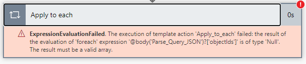
for the flow we only reference the 2nd parcels layer and are trying to use the HCAD number (Parcelid which is a string) to relate the submitted data to the target data. but we keep getting this error. Is it because the parcelids in the form and 2nd layers are strings? or am i missing something else?
We got this flow from this blog post "Webhooks, Microsoft Flow and the ArcGIS Rest API – Automating Your Web GIS
": https://lnkd.in/gU5m4V5
Can any one help?
#powerautomate #survey123 #webhooks #json
#arcgisonline #microsoftflow #developer
#restapi #esri #help #automatedprocesses
- Mark as New
- Bookmark
- Subscribe
- Mute
- Subscribe to RSS Feed
- Permalink
Hi @DavidMcClennen -
This is way old, but did you ever figure this out? I am having the same problem!
Thanks,
- Mark as New
- Bookmark
- Subscribe
- Mute
- Subscribe to RSS Feed
- Permalink
Currently no, but we will be going with esri's new updated damage assessment solution since it's officially what FEMA expects. but internally we want extra data for our own analysis such as initial damage cost. so what we're doing is adding additional fields that will be auto populated using HTML in popups taking data from a certified parcels layer that contains the county's appraised value for the property. the parcels layer will have a relationship class with a damage reports table and thats how we'll track the reports for each feature and even for future events.
so the flow would look like this,
select parcel-select hyperlink to survey123form for related damage reports table [FEMA forms]-[HTML code in the link passes appraised value and location info to form]- fill out the rest and submit
no i dont have to ensure the people doing the assessing are right in front of the house when they submit the info is related already to the layer. however i'm having trouble creating the form from the layer. i think the relationship class between the table and layer isn't supported or something else... maybe you might have the answer?
additionally, the form would allow us to continue to try to use webhooks to our office products but i'm now thinking of trying to use fieldmaps to add related records. I haven't tried it yet but i'm hoping i can pass values the same way to the related table.
- Mark as New
- Bookmark
- Subscribe
- Mute
- Subscribe to RSS Feed
- Permalink
Hi @DavidMcClennen ,
Bummer on no solution, but perhaps I can help you with this:
no i dont have to ensure the people doing the assessing are right in front of the house when they submit the info is related already to the layer. however i'm having trouble creating the form from the layer. i think the relationship class between the table and layer isn't supported or something else... maybe you might have the answer?
When creating a Survey123 form "on top of" an existing hosted feature layer, you need to make sure the relationship class is based on GlobalID. This means that the supportsApplyEditsWithGlobalID is set to true. If that is not the case, and it is based on ObjectID or another unique ID field in the data, you will run into trouble creating the form.
There is info on this here - https://community.esri.com/t5/arcgis-survey123-blog/how-to-enable-supportsapplyeditswithglobalids-on...
Hopefully I didn't totally miss what you were asking here.
- Mark as New
- Bookmark
- Subscribe
- Mute
- Subscribe to RSS Feed
- Permalink
Omigod, that is actually super helpful i was racking my brain trying to understand what exactly i was doing wrong but was getting lost in documentation. thanks so much!