- Home
- :
- All Communities
- :
- User Groups
- :
- ArcAPI
- :
- Questions
- :
- Intersecting polygons of same feature class
- Subscribe to RSS Feed
- Mark Topic as New
- Mark Topic as Read
- Float this Topic for Current User
- Bookmark
- Subscribe
- Mute
- Printer Friendly Page
Intersecting polygons of same feature class
- Mark as New
- Bookmark
- Subscribe
- Mute
- Subscribe to RSS Feed
- Permalink
Hi,
I have a feature class. It has polygons, some are overlapping and some are not. I want to get the intersection of those overlapping polygon in arcmap.
How can I do that? Any help will be greatly appreciated.
- Mark as New
- Bookmark
- Subscribe
- Mute
- Subscribe to RSS Feed
- Permalink
Depending on what the purpose is, you can setup a topology and add rules to it to identify where those polygons intersect (overlap). Let us know your purpose and it might help identify the best solution.
Cheers
- Mark as New
- Bookmark
- Subscribe
- Mute
- Subscribe to RSS Feed
- Permalink
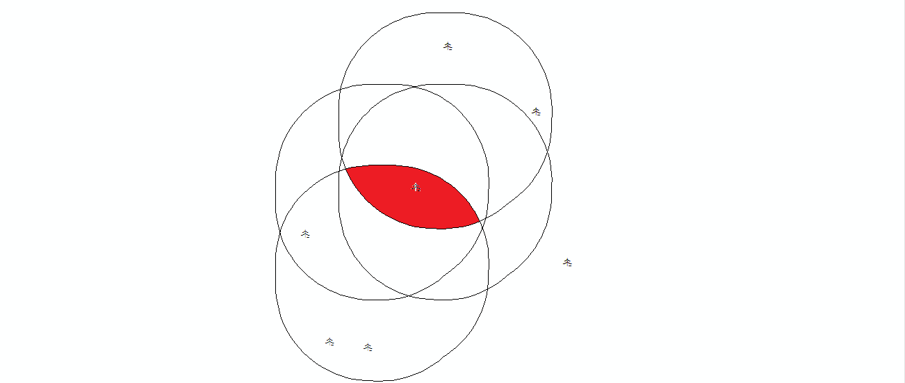
PFA image. I want to get the area marked in red. It is common area between all the intersections.
- Mark as New
- Bookmark
- Subscribe
- Mute
- Subscribe to RSS Feed
- Permalink
Hi Micah,
Intersection works fine when I have only 2 polygons overlapping.
Akshay
- Mark as New
- Bookmark
- Subscribe
- Mute
- Subscribe to RSS Feed
- Permalink
Ah, so all of the polygons in the image above are in the same feature class? Andrew's solution looks interesting and may work. Otherwise, you could do something like this:
# import required modules
import arcpy, os

# export each feature into a standalone feature class using a search cursor and the Select GP tool
table = r"Path to your polygon feature class"
fields = ("OBJECTID")
output_workspace = r"path to scratch workspace"
with arcpy.da.SearchCursor(table, fields) as cursor:
  for row in cursor:
      exp = '"OBJECTID" = {0}'.format(row[0])
      arcpy.Select_analysis(table, os.path.join(output_workspace, arcpy.Describe(table).baseName + "_" + str(row[0])), exp)

# create a python list of the feature classes which you just exported
arcpy.env.workspace = output_workspace
fcList = arcpy.ListFeatureClasses("[base name of your feature class]_*")

# perform the intersection using the list of feature classes which you created in the previous step
arcpy.Intersect_analysis(fcList, result_feature_class)
Really, Esri should just roll the above solution into a new GP tool. Split (analysis) doesn't really do it. Let me know what ends up working for you!
Micah
- Mark as New
- Bookmark
- Subscribe
- Mute
- Subscribe to RSS Feed
- Permalink
Hi Akshay,
What about this:
Step 1
Polygon To Line
Creates a feature class containing lines that are converted from polygon boundaries with or without considering neighboring polygons.
then bring it back together like this...
Step 2
Feature To Polygon
Creates a feature class containing polygons generated from areas enclosed by input line or polygon features.
This effectively splits it all up and then reassembles individual polygons. Area should be simple from there.
- Mark as New
- Bookmark
- Subscribe
- Mute
- Subscribe to RSS Feed
- Permalink
Hi Andrew ,
Thanks for the detailed reply. It is making that intersecting part as separate polygon but than I have to remove the other polygon also.
PFA image.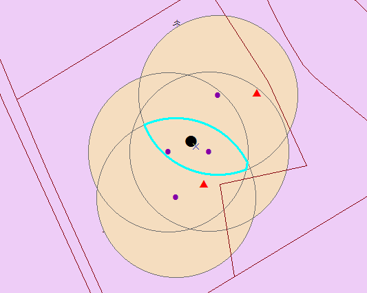
- Mark as New
- Bookmark
- Subscribe
- Mute
- Subscribe to RSS Feed
- Permalink
There are some ideas here: https://community.esri.com/message/200113#comment-200113
I'm partial to the solutions offered by Jim W, and... me. 