- Home
- :
- All Communities
- :
- User Groups
- :
- Addressing
- :
- Questions
- :
- How to use an address range value to create a new ...
- Subscribe to RSS Feed
- Mark Topic as New
- Mark Topic as Read
- Float this Topic for Current User
- Bookmark
- Subscribe
- Mute
- Printer Friendly Page
How to use an address range value to create a new record for each address within the range?
- Mark as New
- Bookmark
- Subscribe
- Mute
- Subscribe to RSS Feed
- Permalink
I have a shapefile of parcels which contains an address for each parcel. Some of these addresses are listed as ranges (e.g. 4422-88 Wissahickon Ave). Is there a way to create a new record for each address within that range? I essentially want many addresses associated with a parcel if the parcel contains many addresses. I am assuming it would require the use of a geocoder, but I am not sure how that could be utilized. Any advice would be great!
- Mark as New
- Bookmark
- Subscribe
- Mute
- Subscribe to RSS Feed
- Permalink
To just get the numbers create a new field called Number, right click the new field and choose Field Calculator. Switch parser to Python and type the following:
!HouseNum!.split(' ',1)[0]
then click ok
- Mark as New
- Bookmark
- Subscribe
- Mute
- Subscribe to RSS Feed
- Permalink
I think the first thing I'd do is clean up those records where the HouseNum ends in N E W or S: Select them as such, and use a python statement smilar to what Tim provides to calc the PreDir field accordingly. Then you can just do a search and replace on ' %' (space any-character) and replace it with '' (no space, no character).
My guess is you got the predirs in your housnum field because there are extra spaces in your address field....
- Mark as New
- Bookmark
- Subscribe
- Mute
- Subscribe to RSS Feed
- Permalink
How about if I wanted to remove the predirs in the housenum field, but write them to the actual predir field?
- Mark as New
- Bookmark
- Subscribe
- Mute
- Subscribe to RSS Feed
- Permalink
I'm not smart enough to do that in one step. Tim probably is.... timw1984
- Mark as New
- Bookmark
- Subscribe
- Mute
- Subscribe to RSS Feed
- Permalink
I thought I was close with this code (ending in "else: return my_direction"):
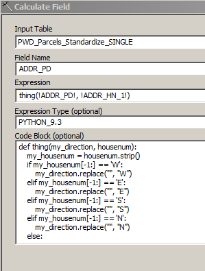
But it returns <Null> for any row where there is a W, E, S, or N attached to the end of the housenum.
- Mark as New
- Bookmark
- Subscribe
- Mute
- Subscribe to RSS Feed
- Permalink
Shannon this worked for me:
Pre-Logic Script Code:
def SPLITTING(test, test2):
if (test2 =='') :
howmany = test.split(' ',1)
if (len(howmany) > 1):
return test.split(' ',1)[1]
elif (len(howmany) == 1):
return
else:
return test2
PreDir box
SPLITTING( !HouseNum!, !PreDir! )
- Mark as New
- Bookmark
- Subscribe
- Mute
- Subscribe to RSS Feed
- Permalink
Thanks for your response, Tim. This code does not produce anything for housenum that ends with a W, E, S, or N for me.
This is a direct copy and paste from the table:
449-57 E
I'm not sure if there's a different character or something in that value that's different from what you have.. I get "WARNING 000405: No records within table."
- Mark as New
- Bookmark
- Subscribe
- Mute
- Subscribe to RSS Feed
- Permalink
Would you be able to share a view rows of your table and upload it as a shapefile here? The first 4 I see in your screenshot would be perfect.
- Mark as New
- Bookmark
- Subscribe
- Mute
- Subscribe to RSS Feed
- Permalink
Whoops! I was working in an older version of that table. It works in this table, though. Thank you!
- Mark as New
- Bookmark
- Subscribe
- Mute
- Subscribe to RSS Feed
- Permalink
Glad it works!