Turn on suggestions
Auto-suggest helps you quickly narrow down your search results by suggesting possible matches as you type.
Cancel
- Home
- :
- All Communities
- :
- Products
- :
- 3D
- :
- 3D Questions
- :
- Solid Subsurface Geologic Models in ArcScene
Options
- Subscribe to RSS Feed
- Mark Topic as New
- Mark Topic as Read
- Float this Topic for Current User
- Bookmark
- Subscribe
- Mute
- Printer Friendly Page
Solid Subsurface Geologic Models in ArcScene
Subscribe
4135
1
06-07-2012 09:03 AM
06-07-2012
09:03 AM
- Mark as New
- Bookmark
- Subscribe
- Mute
- Subscribe to RSS Feed
- Permalink
Hi:
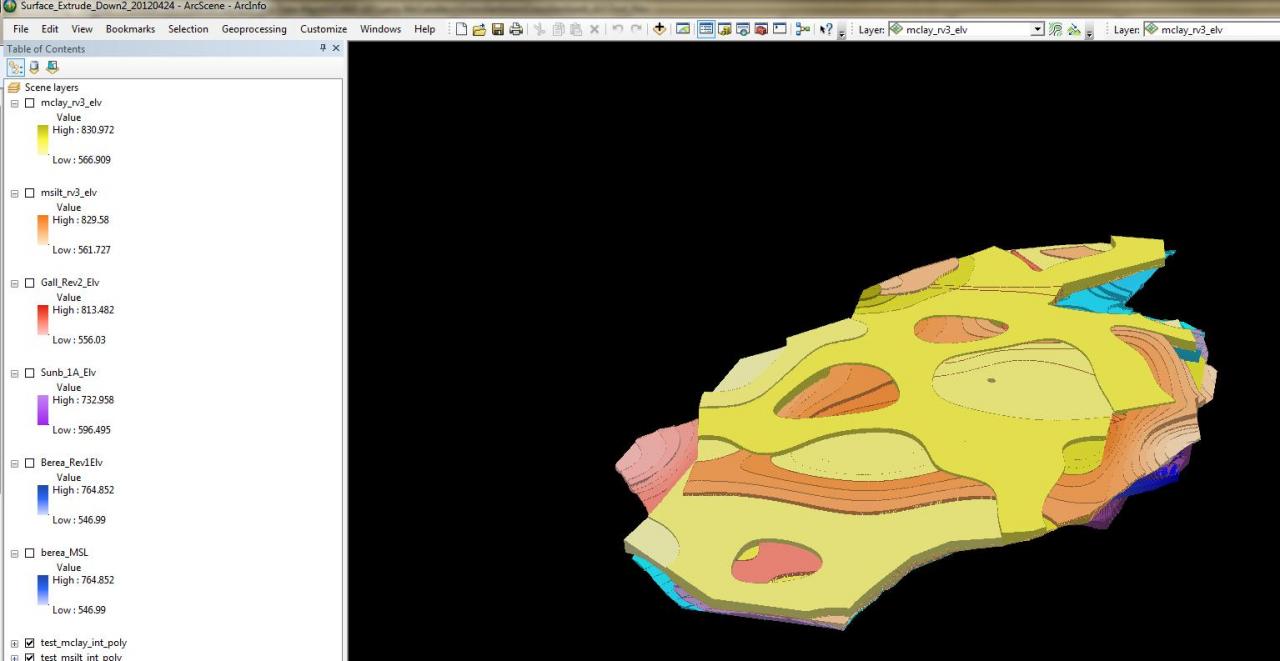
I have been trying to create a solid subsurfce geologic model of our project site using ArcScene. There are two problems: First, the raster are huge. I have seven layers I'm working with and they run from 60 mb to 500 mb. When I try to do anything but display them in ArcScene it takes hours. To answer the obvious questions, yes, I have plenty of RAM (8 gb) and my Virtual Memory is set at 15.99 gb. The second problem is that the distances between the surfaces range from less than a foot to a little over a hundred feet. Turning the surfaces into tins and using the "Extrude Between" command doesn't work because of the small differences in elevation. Almost every part of the extruded surface looks flat.
One thing that did work for me was to turn the rasters into polygons and then set the "Extrusion" tab fields to [GRIDCODE] for the values and "Adding it to each features maximum height" for the extrusion type. Before we added more boreholes and re-interpolated the surfaces this process created a surface that looked like inverted contours (see attached) and I could see how each of the surfaces related to each other. Another nice thing about displaying the data this way is that it adds "thickness" to the layers. The polygon file used to create the "Berea_Rev1Elv" surface in my example had around 300 records. The new Berea polygon layer has over 17,000 polygons. I've tried dissolving the polygons based on the [GRIDCODE] which reduces the number to about 250 records but it still won't display in ArcScene. If it hangs up on just one file there's no way it will display when all of the other layers are added.
I've called ESRI tech support and their suggestion was to use "Extrude Between" which I knew wouldn't work. If anyone else has a suggestion as to how I might get this to work I'd appreciate it or, if there is some software out there that would help me I'd be interested in looking at it.
Thanks for your time.
Julie
1 Reply
06-08-2012
03:59 AM
- Mark as New
- Bookmark
- Subscribe
- Mute
- Subscribe to RSS Feed
- Permalink
I would be curious to know what video card you are using. You have plenty of RAM and have made the change for the virtual memory, but depending on the video card there still may be an issue. Based on experience there are occassional issues with certain AMD/ATI cards that are not reproducible with Nvidia cards, but I encourage you to run this to test out your overall settings. Here are the recommendations for approved video cards. Also depending on your system, if you create a 3d object you like, I recommend using the Layer 3d to Feature to convert it to a multipatch, which is not as memory intensive to draw as the extruded polygon. Also consider smoothing or generalizing your polygon if it is densified to alleviate some of the issues. Finally, remember that ArcScene utilizes a lot of memory, so if you have two monitors, put ArcScene on the main one. Also try turning off any other memory intensive programs prior to running it. I am sure you already have this document, but there are still the recommendations to optimize.