- Home
- :
- All Communities
- :
- Products
- :
- 3D
- :
- 3D Questions
- :
- Prick point through several layers
- Subscribe to RSS Feed
- Mark Topic as New
- Mark Topic as Read
- Float this Topic for Current User
- Bookmark
- Subscribe
- Mute
- Printer Friendly Page
- Mark as New
- Bookmark
- Subscribe
- Mute
- Subscribe to RSS Feed
- Permalink
Hi,
I'm experimenting with ArcGIS 3D and I have several grids, all with different soils.
These types of soil lying on and under each other and I would like a point pierce through all these layers.
How do I do that?
Any help would be appriciated.
Regards,
Joost
Solved! Go to Solution.
Accepted Solutions
- Mark as New
- Bookmark
- Subscribe
- Mute
- Subscribe to RSS Feed
- Permalink
You can do something with a Stacked bar in ArcMap:
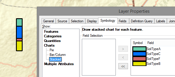
But this is only posible if for each point the soils have the same order, and there is a column for each soil type and it contains the thickness of the layer. Since that is not realistic, you could do this with extrusión, but it requires multiple points on the same location containing data on soilt ype, depth from and depth to.
Something similar as in slide 11 of this presentation (in Dutch, sorry): Bodemdaling model Provincie Utrecht - Grontmij . I created a featureclass with points for every grid cell and extracted all the values and created a related table holding the soil layer for each point.
- Mark as New
- Bookmark
- Subscribe
- Mute
- Subscribe to RSS Feed
- Permalink
If it is visibly, you can use a point and extrude the point:
ArcGIS Help (10.2, 10.2.1, and 10.2.2)
In case you want to extract the values from the different soil layers (is it GeoTop?), then you can use the tool Extract Multi Values to Points (Spatial Analyst)
- Mark as New
- Bookmark
- Subscribe
- Mute
- Subscribe to RSS Feed
- Permalink
Thanks Xander.
The second solution is looking like what I wanted.
Except one thing: Is it possible to create bars (stacked) out of those points which shows how the soil is built up?
For a simplified example see this: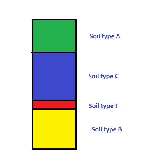
- Mark as New
- Bookmark
- Subscribe
- Mute
- Subscribe to RSS Feed
- Permalink
You can do something with a Stacked bar in ArcMap:
But this is only posible if for each point the soils have the same order, and there is a column for each soil type and it contains the thickness of the layer. Since that is not realistic, you could do this with extrusión, but it requires multiple points on the same location containing data on soilt ype, depth from and depth to.
Something similar as in slide 11 of this presentation (in Dutch, sorry): Bodemdaling model Provincie Utrecht - Grontmij . I created a featureclass with points for every grid cell and extracted all the values and created a related table holding the soil layer for each point.
- Mark as New
- Bookmark
- Subscribe
- Mute
- Subscribe to RSS Feed
- Permalink
Thanks for all the help (and I'm Dutch as well, so that will work out)