- Home
- :
- All Communities
- :
- Products
- :
- 3D
- :
- 3D Questions
- :
- Point data in ArcScene Problems
- Subscribe to RSS Feed
- Mark Topic as New
- Mark Topic as Read
- Float this Topic for Current User
- Bookmark
- Subscribe
- Mute
- Printer Friendly Page
Point data in ArcScene Problems
- Mark as New
- Bookmark
- Subscribe
- Mute
- Subscribe to RSS Feed
- Permalink
I have a group of points which I have successfully converted to 3D points. I only care about one of the points in this group, so I use Select by Attributes to single out the point and make it a new layer. The point simply disappears when I make it a new layer; I can only seem to display groups of points rather than a single point. I realized that by making a new layer out of my selection, the selected point also went back to 2D ("Point" instead of "Point ZM"), is this normal? I converted it back to 3D but still had no luck, it will not display.
I have also tried singling the point out in ArcMap and exporting it to it's own shapefile. I would then use the "Add Surface Information" Tool to add a z-value based on the DEM. Then I tried to display it in ArcScene and pretty much the same thing happens. This time, the point is there but it's IMPOSSIBLE to symbolize. Very very very small (you can only see it by randomly rotating around until you find it, it must only be viewable from certain angles) and is underneath any raster surface it should be sitting on top of given the priority rank, base height offset, or extrusion I have set (I have played with all of them). I'm not even sure it's in the right spot on the map because when I "zoom to layer" it's like no man's land...I think it's underneath my raster surfaces but can't be sure, when I zoom out to far to get a better idea of where it is, my map isn't in the screen anymore. Both layers are projected with the same coordinate system, so it should be lying in the right spot, it's probably just under the raster layer. When I turn off the raster layer, the point is there (I can zoom to it to see it), but is otherwise invisible at full extent, or even half extent.
Is this a problem with my software? A problem with my points? Anyone else have this happen and find a solution?
- Mark as New
- Bookmark
- Subscribe
- Mute
- Subscribe to RSS Feed
- Permalink
If memory serves. As with other layers, did you assign the base heights to the point to be your surface? otherwise, it is just going to be under the surface. Even if you use the point height itself, there is no guarantee that it will be at a higher elevation than a surface
- Mark as New
- Bookmark
- Subscribe
- Mute
- Subscribe to RSS Feed
- Permalink
Yes, I have tried it that way as well, assigning the base heights as my surface. It doesn't work. Thank you for your response though.
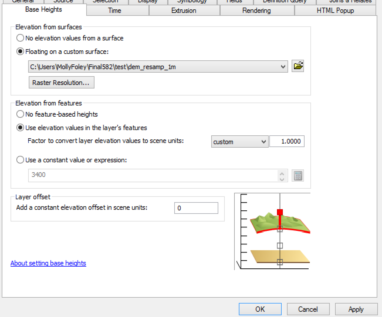
Is it possible to enable under the Base Heights tab, both the "floating on a custom surface" and the "elevation from features"? I have attached images of what I want to do and the results afterward. I wonder if this is where the problem is. I can enable both radio buttons and click apply and it appears as though it accepts this action (still won't see the point on the map however) and click ok to close the dialogue. If I reopen the dialogue, it appears as if the change did not take place and only "floating on a custom surface" will be enabled.
So after playing around some more, I have determined that the point is in the correct spot, however it is underneath the raster surface no matter what I do, and it is impossible to see at any extent (even with all other layers turned off) except for when you hit "zoom to layer." That is the only time the point is visible, no matter how much you change the symbology.
I'm going to take my data to another computer with ArcScene tomorrow and figure out if it's my data or the software on my personal machine. I'm betting its the data but I have absolutely no idea what could be wrong in my data. Everything that's necessary for it to display correctly is there, as far as I can tell.
- Mark as New
- Bookmark
- Subscribe
- Mute
- Subscribe to RSS Feed
- Permalink
Hi Molly,
After reading through your posts there were a few things that I wanted to pass along. The 'Add Surface Information" GP tool attributes features with spatial information from a specified surface. This tool does not convert 2D features to 3D. When you selected the point in question and exported this to a separate feature class, the Point should have preserved z-values. My suspicion is that while the shapefile prior to export had a Point-Z shape identifier, there actually were not z-values written to the points at the geometry level. Therefore my suggestion would be to utilize the 'Interpolate Shape' GP tool which interpolates z-values for a feature class based upon elevation derived from a surface. This will create true 3D features by writing elevation values to the geometry level. If you are ever unsure if these z-values are present you can begin a 3D Edit session within ArcScene->Utilize the edit vertix tool and select a point->right-click within the display->Edit vertices->launch the sketch properties dialogue from the editing toolbar. You will notice that the edit sketch properties window will contain a X,Y and Z column if true z-values are present. With regard to assigning base heights, you will be unable to specify that the feature floats on a surface as well as using elevation values in the layer's features. If you are working with a 2D feature class, utilizing the 'elevation from surfaces' options would allow these features to display on top of the elevation surface. The 'elevation from features' options make use of z-values at the geometry level to display the features in 3D space irrespective of the elevation surface. Hope this helps.
Yuri