Turn on suggestions
Auto-suggest helps you quickly narrow down your search results by suggesting possible matches as you type.
Cancel
- Home
- :
- All Communities
- :
- Products
- :
- 3D
- :
- 3D Questions
- :
- Multiple Single Observer Viewsheds
Options
- Subscribe to RSS Feed
- Mark Topic as New
- Mark Topic as Read
- Float this Topic for Current User
- Bookmark
- Subscribe
- Mute
- Printer Friendly Page
Multiple Single Observer Viewsheds
Subscribe
9058
5
06-29-2011 12:11 AM
06-29-2011
12:11 AM
- Mark as New
- Bookmark
- Subscribe
- Mute
- Subscribe to RSS Feed
- Permalink
I have been trying to figure this out for a while now but I can't seem to find a way to make multiple viewsheds quickly, or at least without hand jamming in the details on each one.
I have access to 9.3 and 10 so solution can be on either one, but the problem is that I need to run 250+ single observer viewsheds all with the same settings.
I have had some success hand making a single observer in MA and sticking it in to 3d analyst but I can't figure out a way to make the whole table into observers unless I cut and past each row individually into the batch tool, which in turn creates 250 individual shapefiles which is a pain.
Also is there a way to automatically clip the raster down to the RADIUS2? Right now it is making a raster of the whole dted mosaic (about a 300km square) and the radius is only 10km.
I am sure there has to be some solution for this that I am overlooking but I have not been able to find one yet.
Thanks.
5 Replies
06-30-2011
10:53 AM
- Mark as New
- Bookmark
- Subscribe
- Mute
- Subscribe to RSS Feed
- Permalink
Greetings,
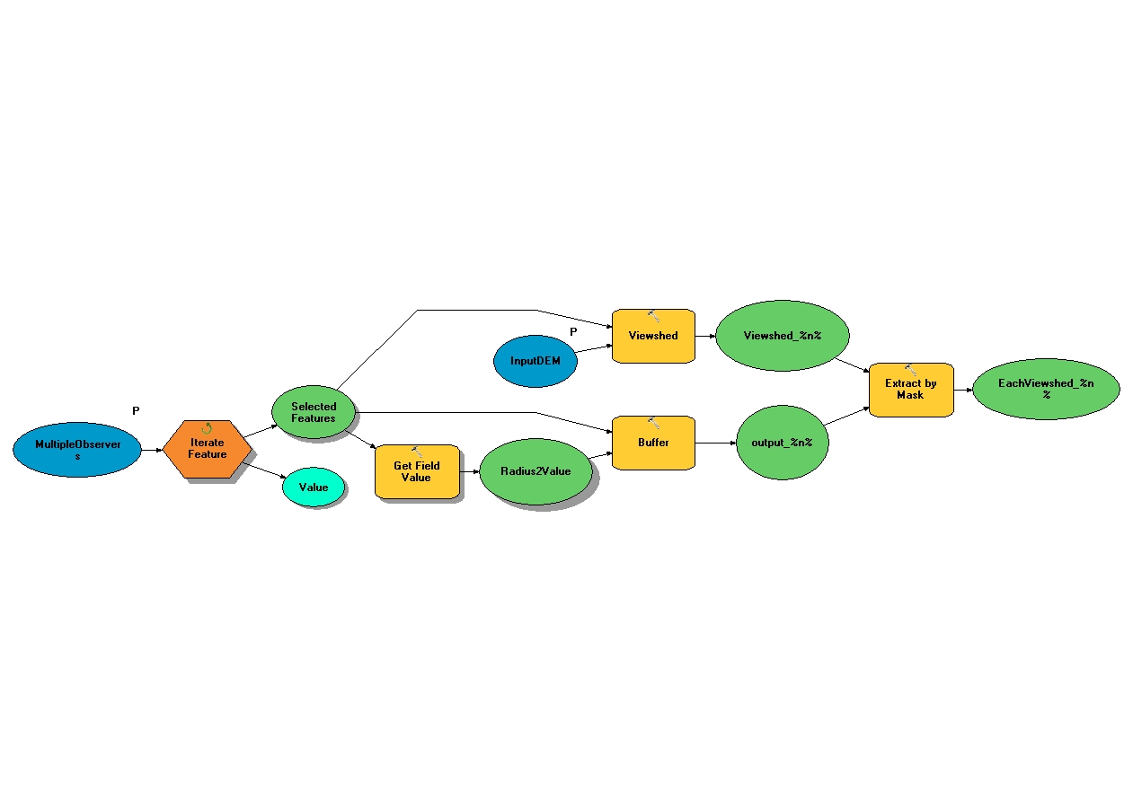
I would definitely suggest using ArcGIS 10.0 for this so you can take advantage of Iterators in Model Builder. You will want to create one point feature class containing all of your points. Then use the Iterate Feature iterator to loop through each point. To clip the resulting viewshed to the Radius2 distance, you will want to use Get Field Value and pass that into the Buffer tool as the distance value. With the polygon created by Buffer, you can extract the resulting viewsheds according to the polygon geometry. Attached is a screenshot of the model I used to test this.
I recommend checking these out since the model makes use of both.
A quick tour of using iterators for iteration�??(Looping)
A quick tour of using inline variable substitution
Regards,
Eric
11-20-2015
01:54 PM
- Mark as New
- Bookmark
- Subscribe
- Mute
- Subscribe to RSS Feed
- Permalink
I'm not sure if anyone is still monitoring this since it's been a couple years since anyone has posted anything...
what is the data type used for Get Field Value?
How does the result of Get Field Value (Radius2Value) connect to the buffer tool? Is the "Selected Features" the input for the buffer?
12-11-2011
11:44 AM
- Mark as New
- Bookmark
- Subscribe
- Mute
- Subscribe to RSS Feed
- Permalink
That is a nice iterative model for clipping the viewsheds to a variable view distance buffer. One thing that will increase performance greatly is to set the environment extent of the viewshed tool to the buffer result. To do this drag a line from the buffer output to the viewshed tool, and when prompted select the environment variable extent. This will cause the viewshed tool to only consider pixels within the extent of the buffer, and not waste processing time on areas outside the rectangle of your buffer. At version 10 you can use the RADIUS2 attribute, which if present will automatically clip the viewshed. The default for RADIUS2 is infinity. Search the help for 'Using Viewshed and Observer Points for visibility analysis' and scroll to the bottom of that page.
04-16-2012
06:02 PM
- Mark as New
- Bookmark
- Subscribe
- Mute
- Subscribe to RSS Feed
- Permalink
Hi, just wondering if you guys could help me out - you seem to know what you're doing!!
I'm looking to create a viewshed analysis for a road network, in order to analyse which route has the best view.
I have a DEM and road network, but cannot figure out how to compute the viewshed for each road within the network, rather than the entire network itself.
Once i have worked out which roads have views or not, i'll then run a network analysis and find the route with the best view.
The only way I can think of is to run a model, clipping the road network into each segment and running the viewshed, however this is way more in depth than I'd like to go if possible. I've read a few papers that have done viewshed's on trails or roads, but they don't go in enough depth for me to follow what they've done.
Any ideas? Tips? Suggestions?
Cheers!
10-03-2013
01:39 PM
- Mark as New
- Bookmark
- Subscribe
- Mute
- Subscribe to RSS Feed
- Permalink
This method seems like it may work for me, but before I try building this model iterator, I'd like opinions. I have 500 points of wind turbine locations (offset 100 meters) and a DEM. I want to find out the visibility up to 15 miles per point (this radius will overlap with other points). Using this method, after each viewshed is created and clipped to the preferred distance, can you create a vector polygon file containing just the visible viewshed area? I'd then like to merge each of these polygon viewshed boundary shapefiles into one shapefile. I need to ultimately analyze the demographics (which is a polygon shapefile of census blocks) within each tower's visible viewshed. Does this seem like it would work using this method?