- Home
- :
- All Communities
- :
- Products
- :
- 3D
- :
- 3D Questions
- :
- Is the Contour Line with the Zero value attribute ...
- Subscribe to RSS Feed
- Mark Topic as New
- Mark Topic as Read
- Float this Topic for Current User
- Bookmark
- Subscribe
- Mute
- Printer Friendly Page
Is the Contour Line with the Zero value attribute in the Surface Contour tool's output the first contour elevation e.g. 5 Ft. or is it a base line i.e = to zero elevation?
- Mark as New
- Bookmark
- Subscribe
- Mute
- Subscribe to RSS Feed
- Permalink
Hi,
Can someone tell me if in the contour layer output of the Surface Contour tool (being run on a terrain) - is the line with the attribute zero in the Contour Field (output file) literally equal to a zero elevation? Or is the line with the attribute zero in the Contour Field the first contour in your interval, for example the 5 ft. line in a contour file with 5 ft. intervals?.
I am uncertain if I should consider this "0 contour" a shoreline and the "1 Contour" the the first (3Ft) contour in my interval or is the line with the 0 value in the Contour Field actually the first elevation contour - the 3 ft. line.
I don't see an input in the surface contour tool that actually creates / populates an elevation value field for the line segment. Am I missing something there?
When I spot check elevations on the terrain with the output contours laid over it - it appears (in some areas) the zero attribute contour line is the shoreline, but it does not align very well with a high resolution, well referenced aerial image and the 12 ft contour a little higher up does agree with a contour layer from another source. Simply can't afford to mislabel these lines.
Thanks,
Jim
Solved! Go to Solution.
- Mark as New
- Bookmark
- Subscribe
- Mute
- Subscribe to RSS Feed
- Permalink
I'd take a full time GIS job first. I'll worry about the raise later.
- Mark as New
- Bookmark
- Subscribe
- Mute
- Subscribe to RSS Feed
- Permalink
James,
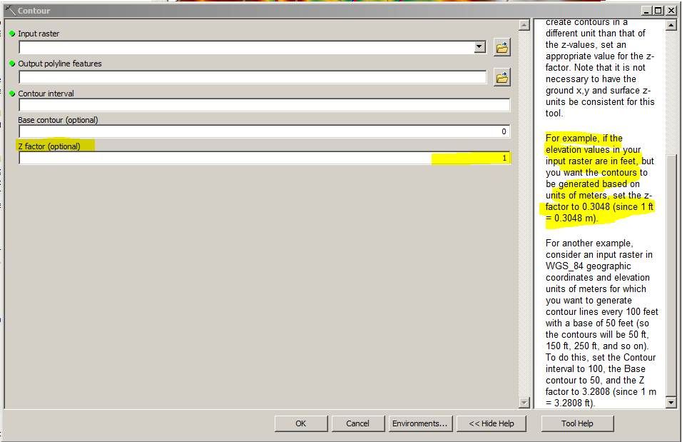
Does your Contour tool have a Z factor input? This is where you would put the conversion (3.28084 feet = 1 meter), and the contour interval would be 3, for every 3 feet. Of course this particular tool only works on rasters, but if you have 3D analyst, under triagulated surface, there is the Surface Contour tool. It does the same thing but you you can also plug in a terrain or tin. If you dont have 3D analyst, you can spit out a raster and generate contours from that using this function below.
FYI - The resample method I alluded to earlier only works with rasters apparently, but it basically takes your raster in whatever units, and converts each cell by whatever the math works out to be (ie. 1 ft cells become .3048 meter cells)
- Mark as New
- Bookmark
- Subscribe
- Mute
- Subscribe to RSS Feed
- Permalink
Thanks Jeffry - but unfortunately I missed the obvious. You can get elevation values in the Contour field when you are doing a unit conversion on the fly - but you have to open up the spigot on the decimal places. The precision is adjustable before you run the tool. See Ian's screen grab.
Thanks to both of you.
Jim
- Mark as New
- Bookmark
- Subscribe
- Mute
- Subscribe to RSS Feed
- Permalink
Just a stupid observation, but isn't zero still zero in both meters and feet?
- Mark as New
- Bookmark
- Subscribe
- Mute
- Subscribe to RSS Feed
- Permalink
Of course, But are you suggesting meters and feet are the same just because they have 0 in common?
- Mark as New
- Bookmark
- Subscribe
- Mute
- Subscribe to RSS Feed
- Permalink
Yes, but what should have been .914 meter contours(aka 3ft but the table was storing it as meters but as an integer via truncation) made it an elevation of 0 in the attribute table. So while some contours with a table elevation of 0 were truly 0 elevation, others were 3ft but were given a value of 0(due to the tool parameters when first ran). Once the correct precision was applied during the running of the tool, there were true decimal meter elevation values in the table which could then be turned into feet.
- « Previous
-
- 1
- 2
- Next »
- « Previous
-
- 1
- 2
- Next »