- Home
- :
- All Communities
- :
- Products
- :
- 3D
- :
- 3D Questions
- :
- Create vertecs every 5m for interpolate shape from...
- Subscribe to RSS Feed
- Mark Topic as New
- Mark Topic as Read
- Float this Topic for Current User
- Bookmark
- Subscribe
- Mute
- Printer Friendly Page
Create vertecs every 5m for interpolate shape from Lidar GRID?
- Mark as New
- Bookmark
- Subscribe
- Mute
- Subscribe to RSS Feed
- Permalink
Hello all,
I want to create profiles form Lidar data (5x5 m grid) through 3D analyst in ArcMap.
My steps in toolbox: Fill, Fl. direction, Fl. accumulation, Reclasiffy,Str. link, Str. to feature, Interpolate shape.
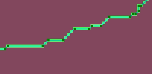
I have one problem: I need to interpolate vertecs only, but vertecs are not every 5m. When the stream is straight for example 40m, ArcMap just make one vertec in 40m (see the picture).
Have anybody some idea to make vertecs every 5m? I have not check "Simplify polylines" in Stream to feature, but it doesnt help.
Thanks a lot.
- Mark as New
- Bookmark
- Subscribe
- Mute
- Subscribe to RSS Feed
- Permalink
Try following steps:
1. Use extract by mask tool and extract the pixels below the polyline.
ArcGIS Help (10.2, 10.2.1, and 10.2.2)
2. Convert the extracted raster to points Using Raster to points tool
ArcGIS Help (10.2, 10.2.1, and 10.2.2)
3. Use the point to split the line using split line at point tool
Hope this is helpful
Kishor
- Mark as New
- Bookmark
- Subscribe
- Mute
- Subscribe to RSS Feed
- Permalink
Since you have a vector line, simply use the Densify Tool if you have the appropriate license level or this one if you are working with shapefiles