- Home
- :
- All Communities
- :
- Products
- :
- 3D
- :
- 3D Questions
- :
- Calculating 3D Measure
- Subscribe to RSS Feed
- Mark Topic as New
- Mark Topic as Read
- Float this Topic for Current User
- Bookmark
- Subscribe
- Mute
- Printer Friendly Page
Calculating 3D Measure
- Mark as New
- Bookmark
- Subscribe
- Mute
- Subscribe to RSS Feed
- Permalink
Hi,
I have a point layer with a few attributes including "odometer" and "elevation" ones. What I need to do is to create a polyline by connecting the points based on the "odometer" column and calculate 3D measure based on the embedded X/Y coordinates and elevation assigned to each point. How do I do this? I have access to Spatial Analyst and 3D Analyst extensions if needed.
Thanks a lot for any help!
Magic
- Mark as New
- Bookmark
- Subscribe
- Mute
- Subscribe to RSS Feed
- Permalink
I've moved your post into the 3D space. You will get a much better answer here as the GeoNet Help is intended for community help and feedback. You can see more on the community structure, and what topics are under each space from the following documents:
ArcGIS Discussion Forums Migration Strategy
Thanks!
Timothy
- Mark as New
- Bookmark
- Subscribe
- Mute
- Subscribe to RSS Feed
- Permalink
Hi,
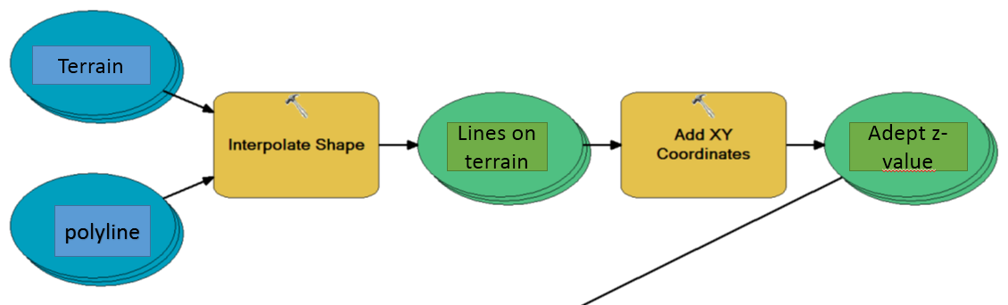
Just thinking loud here: what if you made a terrain from your points height values, used point to lines to make polylines, and then calculated the elevation from the terrain to your lines. Maybe something like this:
-Jørn
- Mark as New
- Bookmark
- Subscribe
- Mute
- Subscribe to RSS Feed
- Permalink
I don't think a surface is necessary if you use ET GeoWizards. If there are multiple paths, each path would have need a unique ID (if not you would still need to give the points a Path ID) and the points for the path hopefully have some sort of order field or time stamp that they can be sorted by from first to last. If you do, you can just use ETGeowizards Convert tools to go from Shape to ShapeZ.