Turn on suggestions
Auto-suggest helps you quickly narrow down your search results by suggesting possible matches as you type.
Cancel
- Home
- :
- All Communities
- :
- Products
- :
- 3D
- :
- 3D Questions
- :
- Re: Artifacts when changing to UTM
Options
- Subscribe to RSS Feed
- Mark Topic as New
- Mark Topic as Read
- Float this Topic for Current User
- Bookmark
- Subscribe
- Mute
- Printer Friendly Page
Artifacts when changing to UTM
Subscribe
10469
6
03-21-2012 11:03 AM
03-21-2012
11:03 AM
- Mark as New
- Bookmark
- Subscribe
- Mute
- Subscribe to RSS Feed
- Permalink
I have some 1/3 arc sec data from USGS seamless data server (datum = D_North_American_1983) for San Francisco South and nearby quadrangles. I can create a reasonable hillshade using a z factor of 0.00003 and everything looks fine. However, to create a slope map, it appears that I need to change the projection to UTM. When I project the data in NAD_1983_UTM Zone_10N, I get east-west and north-south artifacts in the hillshade and slope maps (see sample image). [ATTACH=CONFIG]12902[/ATTACH] . Does anyone know how to avoid having those artifacts or what is causing them? Are these data somehow nor compatible with the projection tool?
6 Replies
03-21-2012
11:12 AM
- Mark as New
- Bookmark
- Subscribe
- Mute
- Subscribe to RSS Feed
- Permalink
Hello and greetings!
Please take a look at the following Knowledge Base - Technical Article Why are there raster artifacts visible in hillshade results when something is performed on a project...
Hope this helps.
Thank you.
Please take a look at the following Knowledge Base - Technical Article Why are there raster artifacts visible in hillshade results when something is performed on a project...
Hope this helps.
Thank you.
03-21-2012
01:45 PM
- Mark as New
- Bookmark
- Subscribe
- Mute
- Subscribe to RSS Feed
- Permalink
Yes, I am aware that the problem existed early in ArcGIS 9, but the note at the bottom of the page indicates it was corrected in later versions. I'm using ArcGIS 10.
Hello and greetings!
Please take a look at the following Knowledge Base - Technical Article Why are there raster artifacts visible in hillshade results when something is performed on a project...
Hope this helps.
Thank you.
03-21-2012
03:12 PM
- Mark as New
- Bookmark
- Subscribe
- Mute
- Subscribe to RSS Feed
- Permalink
Yes, I am aware that the problem existed early in ArcGIS 9, but the note at the bottom of the page indicates it was corrected in later versions. I'm using ArcGIS 10.
I think the problem mentioned on the note of the knowledge base article is that in ArcGIS 9.0, even if you select bilinear or cubic, it always uses nearest (default). This issue was fixed on 9.1. However, even in 10 nearest is the default resampling technique for project raster tool. Please make sure you are using either Bilinear or Cubic when projecting the DEM (as in screen capture below). If you still seeing the artifacts after this, I would suggest you to log a support incident so that we can look into this.
[ATTACH=CONFIG]12913[/ATTACH]
03-21-2012
04:22 PM
- Mark as New
- Bookmark
- Subscribe
- Mute
- Subscribe to RSS Feed
- Permalink
I think the problem mentioned on the note of the knowledge base article is that in ArcGIS 9.0, even if you select bilinear or cubic, it always uses nearest (default). This issue was fixed on 9.1. However, even in 10 nearest is the default resampling technique for project raster tool. Please make sure you are using either Bilinear or Cubic when projecting the DEM (as in screen capture below). If you still seeing the artifacts after this, I would suggest you to log a support incident so that we can look into this.
[ATTACH=CONFIG]12913[/ATTACH]
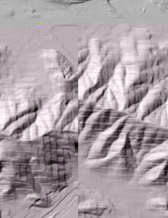
Yes, I still see the artifacts with cubic or bilinear selected. Here is part of San Bruno Mountain in the San Francisco South quad.[ATTACH=CONFIG]12918[/ATTACH]
03-21-2012
05:49 PM
- Mark as New
- Bookmark
- Subscribe
- Mute
- Subscribe to RSS Feed
- Permalink
It looks very difficult
03-22-2012
06:54 AM
- Mark as New
- Bookmark
- Subscribe
- Mute
- Subscribe to RSS Feed
- Permalink
Per the information on the USGS website, the 'artifact' effect is due to the manner in which they sample the data. Products that are projected or created from the DEM will expose the effect you are seeing. Per their help,
The only way to eliminate the striping has been to follow the technique described here with the fourier transformation. Using FocalStatistics can also be used in some areas, but the tradeoff is the generalization of the data.
The information described is how to minimize the look of the striping, not a fix per se. There is also more information on the USGS site recommending the same resampling techniques, which the previous posters reference.
To recap, basically it is in your data if you are changing the resampling and it is still apparent. The transformation is the only way and you have remove from base data.
Q. Will the striping, evident in level 1 DEM's, be eliminated in the NED processing?
A. The striping is in the original source DEM's that were processed as Level 1 using the GPMII or Manual Profile methods. Any DEMs that are produced by photogrammatic methods are considered to be Level 1. Level 1 Methods are:
Manual Profiling--- Operator used stereoplotters to create orthophotos in the 1970's and 1980's while simultaneously creating digital profile information for DEMs.
This method produced the "stripping" seen in some level 1 DEMs.
GPM2 (Gestalt Photo Mapper Model 2)--- This was an instrument that was semi automated to produce orthophotos and DEMs at the same time from photography.
GPM2 DEMs can have an appearance of a grid pattern when a shaded relief graphic is produced from the DEM.
The filtering process used for NED production does not filter out all of these areas. As new DEM's (Level 2 or 3) are produced for these areas, they will replace the Level 1 source.
The only way to eliminate the striping has been to follow the technique described here with the fourier transformation. Using FocalStatistics can also be used in some areas, but the tradeoff is the generalization of the data.
The information described is how to minimize the look of the striping, not a fix per se. There is also more information on the USGS site recommending the same resampling techniques, which the previous posters reference.
Q. When resampling NED, should I use Cubic Convolution, Bilinear interpolation or Nearest Neighbor?
A. Cubic Convolution and Bilinear Interpolation are the preferred methods of resampling digital elevation data, and will result in a smoother appearance. Nearest Neighbor has a tendency to leave artifacts such as stairstepping and periodic striping in the data which may not be apparent when viewing the elevation data but might affect the derivatives, such as shaded relief or slope.
To recap, basically it is in your data if you are changing the resampling and it is still apparent. The transformation is the only way and you have remove from base data.