- Home
- :
- All Communities
- :
- Products
- :
- 3D
- :
- 3D Mapping Questions
- :
- Range Dome Analysis: ArcGIS for the Military
- Subscribe to RSS Feed
- Mark Topic as New
- Mark Topic as Read
- Float this Topic for Current User
- Bookmark
- Subscribe
- Mute
- Printer Friendly Page
- Mark as New
- Bookmark
- Subscribe
- Mute
- Subscribe to RSS Feed
- Permalink
Hello,
Has anyone of you used the range dome analysis template? I am trying to understand and use this template. I followed the instructions given in the solutions website about setting up the template. However when I run the analysis I keep getting the ERROR 050005 (See below).

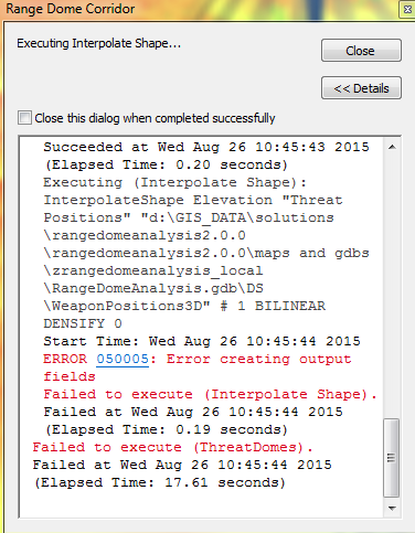
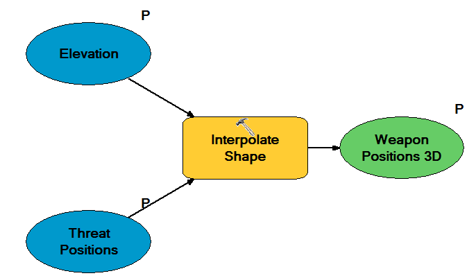
I checked the modelbuilder to look for any broken connections, re-run the model again and got the same error. So then I editted the model and kept the section that was causing the error, which is one of the first steps in the model (see below). I run that small process and got the same error message.
So if any of you have worked with this template and have been able to use it, I would appreciate your insights on this issue.
thanks a lot,
Gabriel
Solved! Go to Solution.
Accepted Solutions
- Mark as New
- Bookmark
- Subscribe
- Mute
- Subscribe to RSS Feed
- Permalink
Hi again,
So I created a new geodatabase instead of using the RangeDomeAnalysis.gdb. Then before running the model, I made sure the output path is set to the new gdb I created. I run the model and it worked.
I still dont get how in the video the air corridor has different elevation values (it goes up) (top image), while mine has the same height all the time (bottom image). It stays at the same altitude...maybe there is something else I need to do, or thats not how flight corridors work


- Mark as New
- Bookmark
- Subscribe
- Mute
- Subscribe to RSS Feed
- Permalink
Gabriel,
I wonder if the problem is related to file system write-permissions on the geodatabase in the "zRangeDomeAnalysis_Local" folder. While ArcGIS is not open, browse to the file geodatabase folder in the file system and right-click "RangeDomeAnalysis.gdb" and click Properties. On the General tab, check to see if the check box for Read Only is checked. If it is, uncheck it, click Apply, and apply the changes to the folder, sub-folders, and files. Then open up ArcScene and try it again.
Best,
Bob
- Mark as New
- Bookmark
- Subscribe
- Mute
- Subscribe to RSS Feed
- Permalink
Hi Bob,
Thanks for your suggestion. I tried to change the properties of the gdb, but after I do, I go back and open the geodatabase folder to see its properties, and the read only box is checked again. I also tried to run the analysis again and nothing happened. I am gonna try creating a new gdb and importing the data to the new one and see if it works.
- Mark as New
- Bookmark
- Subscribe
- Mute
- Subscribe to RSS Feed
- Permalink
Hi again,
So I created a new geodatabase instead of using the RangeDomeAnalysis.gdb. Then before running the model, I made sure the output path is set to the new gdb I created. I run the model and it worked.
I still dont get how in the video the air corridor has different elevation values (it goes up) (top image), while mine has the same height all the time (bottom image). It stays at the same altitude...maybe there is something else I need to do, or thats not how flight corridors work