- Home
- :
- All Communities
- :
- Products
- :
- 3D
- :
- 3D Mapping Questions
- :
- How to Fix International Date Line Issues 3Dfx
- Subscribe to RSS Feed
- Mark Topic as New
- Mark Topic as Read
- Float this Topic for Current User
- Bookmark
- Subscribe
- Mute
- Printer Friendly Page
How to Fix International Date Line Issues 3Dfx
- Mark as New
- Bookmark
- Subscribe
- Mute
- Subscribe to RSS Feed
- Permalink
Hi all,
I have following problem:
I'm trying to display international visitor arrivals to New Zealand with a 3D scene and the 3Dfx widget.
However, lines which are crossing the International Date Line are not visualised correctly.
It looks like the lines are stopping at the IDL.
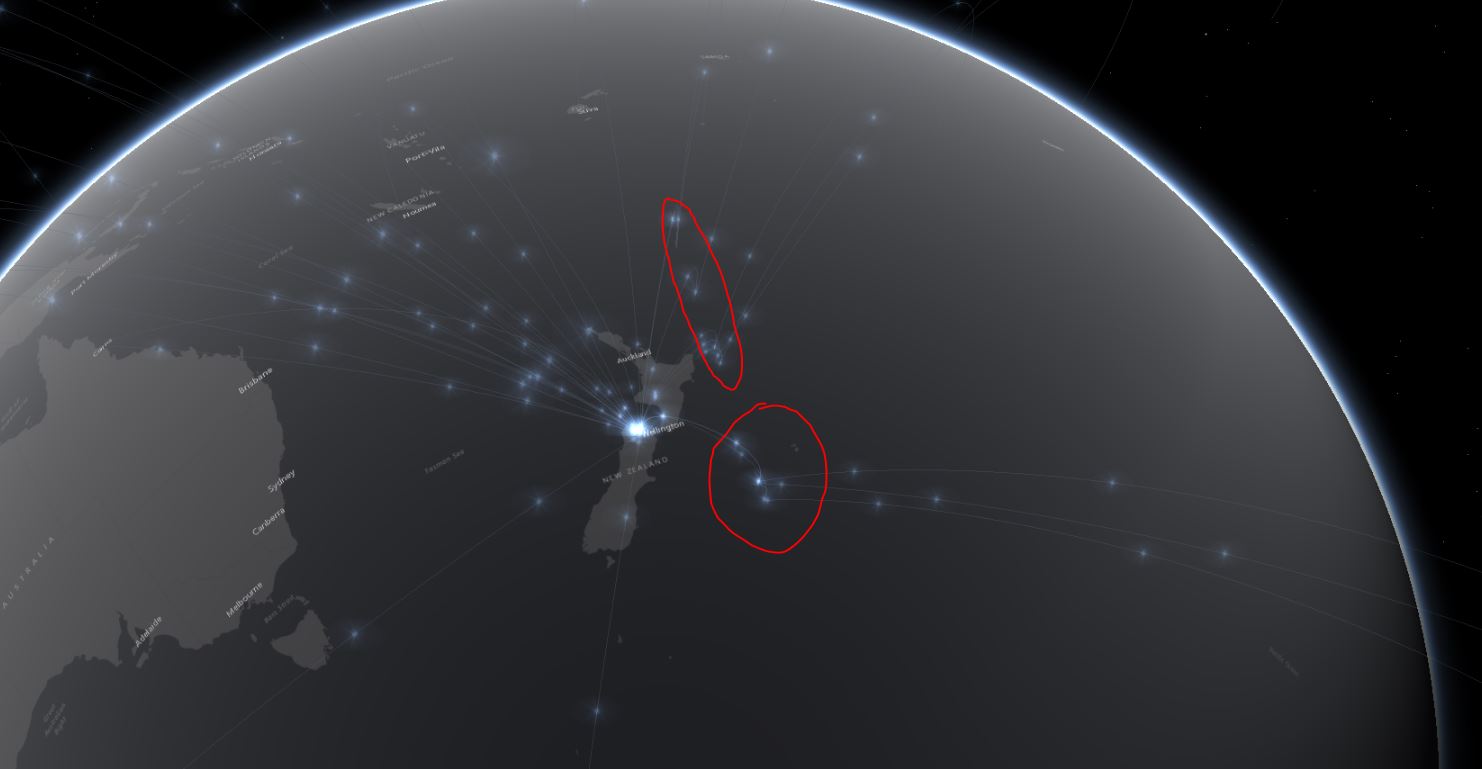
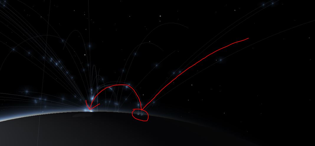
Any ideas how I can fix that?
Solved! Go to Solution.
Accepted Solutions
- Mark as New
- Bookmark
- Subscribe
- Mute
- Subscribe to RSS Feed
- Permalink
Marco, thanks for the sample app and data. The challenge is when a line goes from a point in Japan to another point in US, for example, we don't really have a way to know that it is meant to go via the Pacific Ocean or via Europe. We don’t “automatically” pick the shortest distance. Instead, we assume that the data has been normalized correctly. To workaround, you may try the followings:
1. Provide the data in a way that indicates “across dateline”.For example, by adding 360 degrees to put in the “next” world, ie, instead of using
paths: [
[-119, 33], // US
[117, 40] // China
]
use
paths: [
[241, 33], // US <!-- Note the “241”!
[117, 40] // China
]
Once the data is like that, you can “normalize” it using
https://developers.arcgis.com/javascript/latest/api-reference/esri-geometry-support-normalizeUtils.h...
Jianxia
- Mark as New
- Bookmark
- Subscribe
- Mute
- Subscribe to RSS Feed
- Permalink
Marco,
Is it possible to share a sample of data so we can take a look? Thanks,
Jianxia
- Mark as New
- Bookmark
- Subscribe
- Mute
- Subscribe to RSS Feed
- Permalink
sure:
here is the link to the app: http://arcg.is/CqGP9
I converted XY data to lines using ArcGIS Pro (XY to line).
Here the input data: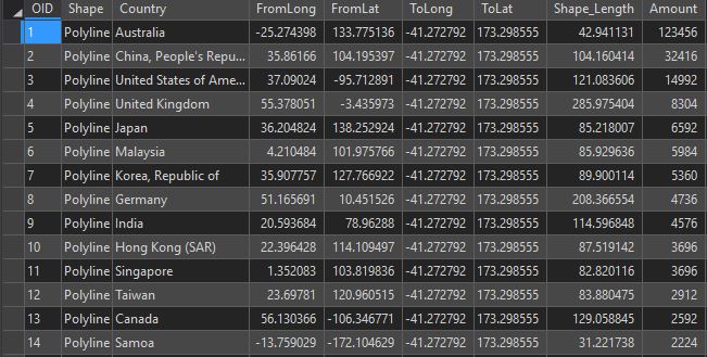
That's how it looks like in ArcGIS Pro: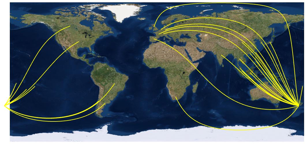
- Mark as New
- Bookmark
- Subscribe
- Mute
- Subscribe to RSS Feed
- Permalink
Marco, thanks for the sample app and data. The challenge is when a line goes from a point in Japan to another point in US, for example, we don't really have a way to know that it is meant to go via the Pacific Ocean or via Europe. We don’t “automatically” pick the shortest distance. Instead, we assume that the data has been normalized correctly. To workaround, you may try the followings:
1. Provide the data in a way that indicates “across dateline”.For example, by adding 360 degrees to put in the “next” world, ie, instead of using
paths: [
[-119, 33], // US
[117, 40] // China
]
use
paths: [
[241, 33], // US <!-- Note the “241”!
[117, 40] // China
]
Once the data is like that, you can “normalize” it using
https://developers.arcgis.com/javascript/latest/api-reference/esri-geometry-support-normalizeUtils.h...
Jianxia