- Home
- :
- All Communities
- :
- Products
- :
- 3D
- :
- 3D Mapping Questions
- :
- How can I create shapes from different depth of la...
- Subscribe to RSS Feed
- Mark Topic as New
- Mark Topic as Read
- Float this Topic for Current User
- Bookmark
- Subscribe
- Mute
- Printer Friendly Page
How can I create shapes from different depth of lake's bathymetry?
- Mark as New
- Bookmark
- Subscribe
- Mute
- Subscribe to RSS Feed
- Permalink
Hello guys,
I am new on working with ArcGIS so that I have had some problems trying to figure out which tool I could apply for this issue.
I have the bathymetry of a lake. From this data I generate a TIN, so I could visualize the 3D profile of the Lake. Now, I would like to generate 2D shapes from this TIN in different depths. How can I make it?
The main reason that I'd like to do it is because I have the temperature measurements from different points of the Lake and I'm trying to generate the 2D profiles of the temperature for each depth. However, the boundary condition must be the lake's profile in the respective depth. If someone knows a path for making that, please let me know.
Thank you,
Everton
- Mark as New
- Bookmark
- Subscribe
- Mute
- Subscribe to RSS Feed
- Permalink
hmmm you could reclassify or slice the input data at your threshold values. It should allow you to get a 2D perspective of the elevation/depth profile at the values you require. It would be an incremental process if you want to produce layers of values of above depth X and below depth X (is done best with raster rather than tin) If represented in raster, then Con would also work)
- Mark as New
- Bookmark
- Subscribe
- Mute
- Subscribe to RSS Feed
- Permalink
I noticed that you have temperature measurements from different "points" of the lake...If the temp measurements are point type, what you could do is interpolate a raster of the temperature recordings.
When you interpolate the raster surface...be sure and set the lakes boundary as your processing extent.
Next....bring the new temperature raster into your scene and set the base height to your lake tin (in the properties menu).
This should drape the 2d temperature data onto the 3d lake basin....(Sort of like an empty bowl painted like the raster would look)
Another option might be to create an field in the temperature points attribute table that contains the "depth" that the temp was recorded....and use that to make a separate tin of temp locations (NOT the lake basin)...then set the base height of your points to your new tin.....turn off the tin...and turn on the lake basin tin.....you are left with "floating" points in the lake basin ; each at their respective depth. These could be symbolized as large 3d points even with color scale set to temperature.
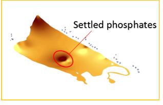
Here is an example using phosphate measurements instead of temperature (Hard to see its in 3D because you cant rotate this snapshot, but it is a 3D lake basin)
Good luck.  Keep me posted on how it goes. Im VERY interested in any 3D bathymetry projects.