Steve's 3D Blog

2343
4
07-29-2014 10:01 PM
SteveSnow
Esri Contributor
7 4 2,343

7/30/2014

Okay, well I've been putting it off for long enough.  Its time to play with some of the Geonet features such as creating my first attempt blog.  I'm not sure how many readers have started blogging but any advice would be greatly appreciated.

Creating your LAS Dataset in 30 seconds.

The subject of my first blog is creating your own LAS Dataset in ArcGIS in 30 seconds.

I have basically summed this up in 2 steps.

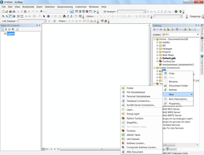
1. in the Catalog window Right Click and Choose New LAS Dataset

.

2. now that the LAS Dataset is made right click on it and choose properties the following screen will pop up.  So choose the 2nd tab on top point to files and add.  Press OK.

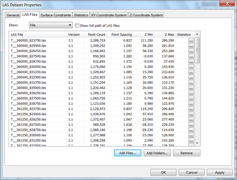
You should see details on each file that is added.  If you would like to see a good resource on this topic please check out the following link.

View and Analyze‌ this will cover more of the basics.

4 Comments
CarolJohnson
New Contributor

Steve

Thank you for starting on this path to give us 30 second and deeper tips. I am a newbie so I found this very helpful. A request. Your screen shots are relatively low resolution so when I zoom in ipad they are hazy. If you could increase original to maybe 150 dpi or 200 dpi that would help me.

SteveSnow
Esri Contributor

Thanks Carol, I appreciate the feedback I will try to figure that part out.  I was simply taking a screen capture and pasting it into the Geonet editor. 

I think if I try inserting the image instead with the GeoNet Tools they may turn out better.

I hope to have another one done this weekend.

EarlKlug
New Contributor II

I would like to see a export to word or excel file to add to a paper for all the results.  Great option as took 60 min for a 898 tiled area using Bare Earth (1.5 billion points) and 90 minutes for same tile but first return.

ArthurCrawford
Esri Contributor

You should next hit statistics and how to understand them.

About the Author
Follow twitter @Steve_Snow_