- Home
- :
- All Communities
- :
- User Groups
- :
- Local Government Solutions Users
- :
- Questions
- :
- Re: Parcel Drafter XY location and meters/feet iss...
- Subscribe to RSS Feed
- Mark Topic as New
- Mark Topic as Read
- Float this Topic for Current User
- Bookmark
- Subscribe
- Mute
- Printer Friendly Page
Parcel Drafter XY location and meters/feet issue
- Mark as New
- Bookmark
- Subscribe
- Mute
- Subscribe to RSS Feed
- Permalink
- Report Inappropriate Content
I recently started using Parcel Drafter in the standard WAB and came across some weird issues from my initial setup.
1) The XY location does not seem to work (or I do not know how to work it). Whenever I put anything in, it sends me to 'null island'. Whenever I use the testing application that Esri hosts, it still does not take me where I want it to go. I assumed that X was Longitude and Y is Latitude. Is it Northing and Easting instead? Is there documentation on setting the XY location?
2) I put in a simple land unit and it worked as expected with five simple calls. However, it converted my inputted ftUS into what seems to be meters, but still labels it as feet. I am not sure where this conversion is happening and/or how to stop it. This does not happen in the testing application. Here is a screenshot:
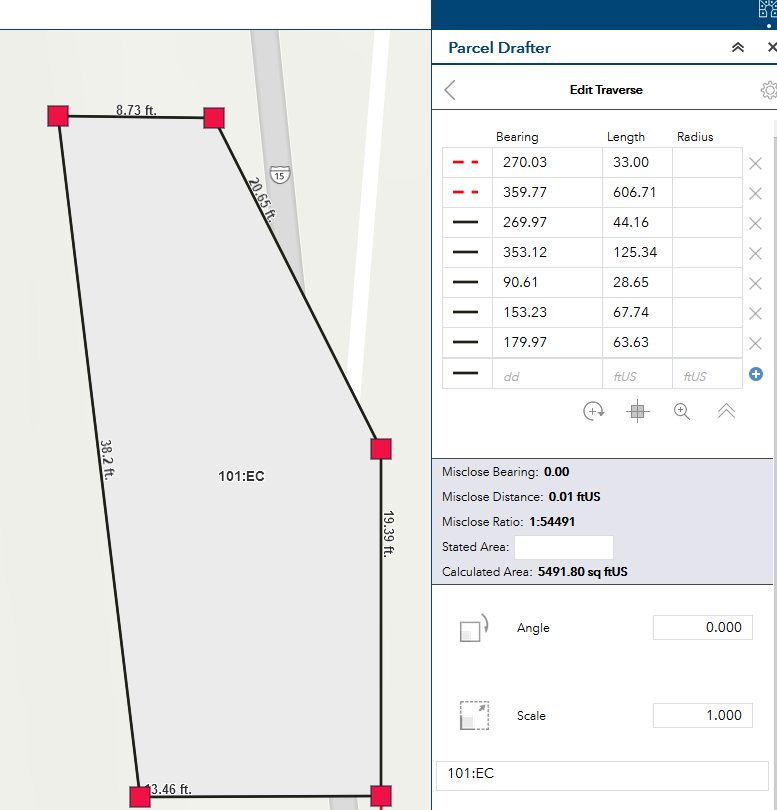
You can see where it is labeled as 38.2 ft. on the left hand side. But the written call on the right hand side says 125.34 feet (and that's in "ftUS"). Where and why is this conversion happening?
3) Bonus question, when I put in a bearing like "s89-23-08e" it auto-converts to 90.61, which makes sense. Is there a way to keep my original input of the dms with directions?
4) Additional and harder bonus question: Is there a way to input in a ton of calls (of metes and bounds) at once with a CSV or spreadsheet to draw a massive parcel (or to draw many parcels)?
Thanks for your help!
tagging Chris Buscaglia
- Mark as New
- Bookmark
- Subscribe
- Mute
- Subscribe to RSS Feed
- Permalink
- Report Inappropriate Content
Chris,
Thanks that is great.
Attached are is the image:
There are a few angle modifiers that regularly show up in legal descriptions. For example, you have tangency, which you mentioned using the *tb phrase, noted as "tangent direction" above (there is also noted the more rare "ahead tangent direction" that is defined from the end of the arc, rather than the beginning). Glancing at the code you sent Adrian it looks like you may make use of negative radius to achieve tangent curves to the "left" or counterclockwise, and positive for clockwise curves (these are noted above as "curve direction". The "C" is for when someone notes the direction of concavity for the curve rather than saying left or right, or to describe the general direction of a curve. Which is a convention in some areas.
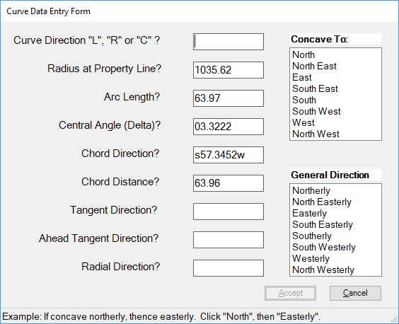
Perhaps you have some for other angle modifiers. Radial direction or radial point is a bearing to the center point of the curve. This is measured at the beginning of the curve. Chord direction we have already covered. Delta angles or Central Angles are very important, the curve will normally close best using delta and radius than with chord bearing and distance.
Do you have other phrases like *tb that you can input?
- Mark as New
- Bookmark
- Subscribe
- Mute
- Subscribe to RSS Feed
- Permalink
- Report Inappropriate Content
Jefferson,
We don't support radial bearings/central angles - everything else is supported.
- + Radius values have been the norm in ArcGIS desktop as our parcel maintenance solution uses that input style.
We do have documentation for other shortcuts - like quadrant bearing (-1 for NE, -2 for SE, etc.).
Create new parcel - Parcel Drafter | ArcGIS Solutions for Local Government
Hope the helps
-Chris
- Mark as New
- Bookmark
- Subscribe
- Mute
- Subscribe to RSS Feed
- Permalink
- Report Inappropriate Content
Chris Buscaglia - Any idea when radial bearings and tangent bearings will be supported? We are trying to implement this in a workflow in our recorder's office and many times we have a non-tangent curve that references the radial bearing instead of the chord bearing.
Summit County, Utah
- Mark as New
- Bookmark
- Subscribe
- Mute
- Subscribe to RSS Feed
- Permalink
- Report Inappropriate Content
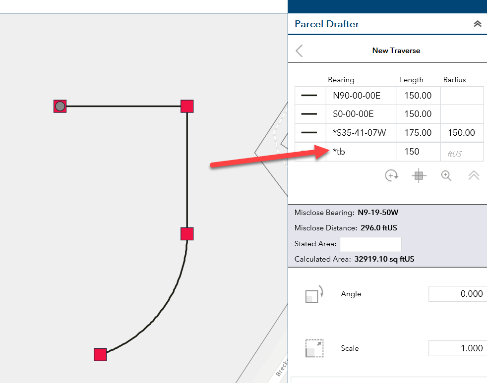
Jeff,
The Parcel drafter supports tangent bearings, see the image below. Using the shortcut *tb will set the course tangent.
Radial Bearings are NOT supported currently, will submit an enhancement request.
Can you send an example doc. my way?
- Mark as New
- Bookmark
- Subscribe
- Mute
- Subscribe to RSS Feed
- Permalink
- Report Inappropriate Content
Chris,
Thanks for the reply, an enhancement would be great. I guess I wasn't very clear in my post, but when I was referring to tangent bearings, I meant tangent bearings as a parameter for non-tangent curves. We very often have descriptions that use non-tangent curve parameters other than chord bearings. Here is an example of a description that has two non-tangent curves with radial bearings for their parameters.
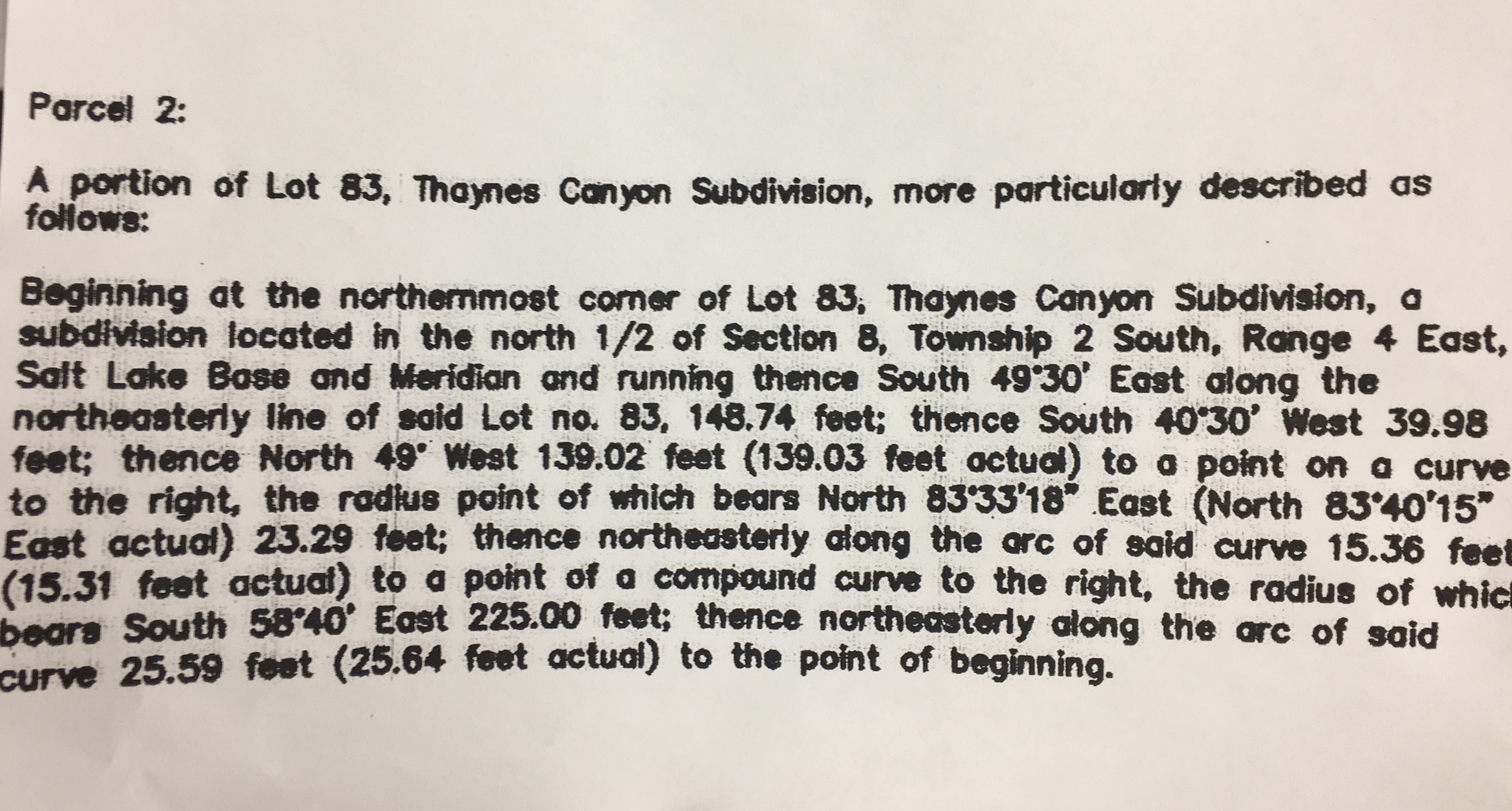
The tricky thing with this description is you don't have an outgoing tangent bearing that would help you by coming around from the back end of the traverse.
It would be nice if the entry grid for the Parcel Drafter functioned like the Parcel Fabric entry grid. I'm not asking for much am I?
Thanks,
Summit County, Utah
- Mark as New
- Bookmark
- Subscribe
- Mute
- Subscribe to RSS Feed
- Permalink
- Report Inappropriate Content
Chris, can you give an update on radial curve support in the Parcel Drafter? I'm looking at implementing this and I'm not sure I can get what I need without it. Thanks!
- « Previous
-
- 1
- 2
- Next »
- « Previous
-
- 1
- 2
- Next »