- Home
- :
- All Communities
- :
- Industries
- :
- Education
- :
- K12
- :
- K12 Discussion
- :
- 2019 ArcGIS Online Competition for US HS+MS Studen...
- Subscribe to RSS Feed
- Mark Topic as New
- Mark Topic as Read
- Float this Topic for Current User
- Bookmark
- Subscribe
- Mute
- Printer Friendly Page
2019 ArcGIS Online Competition for US HS+MS Students
- Mark as New
- Bookmark
- Subscribe
- Mute
- Subscribe to RSS Feed
- Permalink
With skill, passion, and analysis, high school and middle school students are exploring their world and creating maps with ArcGIS . Esri challenges US students to create and share projects about something in their home states, striving to be among the best in the school, state, and nation. Esri's 2019 ArcGIS US School Competition is open to high school ("HS," gr.9-12) and middle school ("MS," gr.4-8) students in the US who can analyze, interpret, and present data via an ArcGIS web app or story map.
Patterned after 2016 state events by Minnesota and Arkansas, Esri launched a national challenge in 2016-17; in 2017-18, 28 states participated (results below). For 2018-19, Esri offers to all states the chance to participate, with grants to states supporting ten equal prizes of $100, for the five best HS and five best MS projects in the state. Schools can submit up to five projects to the state, and states submit to Esri up to ten awardees (up to 5 HS, up to 5 MS), with one project each at HS and MS tagged for a final level of competition. From across the nation, one HS project and one MS project will each earn a trip to the 2019 Esri Education Conference in San Diego, CA, during Esri's 50th year celebration.
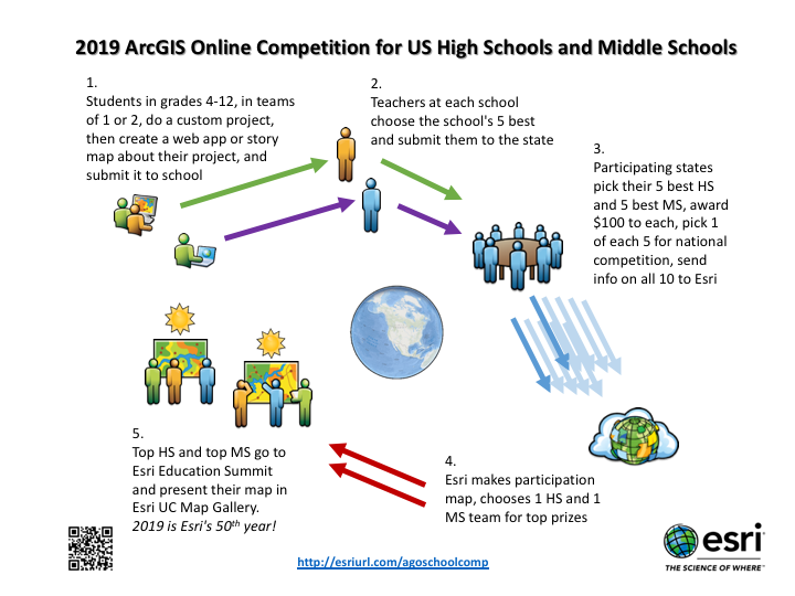
State Leadership Team: Esri seeks state teams to conduct each state's competition (limit of one team per state, covering all 4th-12th graders in the state). The team may consist of geo-savvy adults from schools, higher ed, informal ed, government, business, and non-profit realms; different types of expertise are important; the team's key tasks are spelled out in "VII" below. Team leaders can apply via a form attached to the bottom of this post. (Collaboration, commitment, and proven experience working across the state is required.)
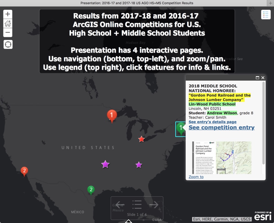
See the 2017+2018 results and 2019 states by clicking the image below, or in map#2 of the US K12 GIS story map.
2018-19 Contest Details:
- Eligibility
- Entrants must be pre-collegiate students registered in grades 4-12, from public schools or non-public schools including home schools, under age 19, who have not yet received a high school diploma or equivalent
- Entrants must reside and be in school in the United States or its districts or territories: 50 states, District of Columbia, Puerto Rico, Guam, Northern Mariana Islands, US Virgin Islands, and American Samoa. (Thus, "state" in this document means one of these 56 units.)
- Students can work singly or in a team of two, but can participate in only one entry. Teams with one student in middle school (gr.4-8) and one in high school (gr.9-12) must be considered as high school.
- Entrants may work on the challenge through school, via a club, or independently, but entries must be submitted to the state from a recognized school or home school.
- Any school or home school program can submit to the state a maximum of five (5) entries total, counting the sum of middle school and high school entries.
- Entries
- Entry forms (student/s to school, school to state, state to Esri) will be made available to state leads in January 2019.
- Entries must be from an ArcGIS Organization account (not a "public account"). Any K12 school (public, non-public, or home school) or formal youth club can request for free an ArcGIS School/Club Bundle (includes an ArcGIS Organization account).
- Entries must be an ArcGIS "web app" or "Story Map".
- Entries must focus on content within the state borders. States may choose to refine the focus further, but the geographic scope of the project must be within the state. The project may reference data outside the state "for context," but may not extend the focus of the study beyond the state borders. For example, broader patterns of environmental characteristics or demographic movements may be referenced for context, but the focus must be on phenomena within the state.
- Schools must announce their own internal deadlines, in time to complete judging and provide information to the state by its deadline. States must announce their in-state deadlines, but can be no later than 5pm Pacific Time on Wed May 15, 2019. States must submit data to Esri no later than 5pm Pacific Time on Wed May 22, 2019.
- Awards
- Esri will announce its awards decision by 5pm Pacific Time on Mon June 3, 2019
- Esri will provide a travel grant to one HS team and one MS team, each team consisting of the student(s) and at least one parent/guardian (could be teacher/rep). Awardee teams must agree to attend the Esri Education Summit ("EdUC"), arriving by 10amPT Sat July 6, and staying through at least 4pmPT Tue July 9, 2019. Awardees will be responsible for handling any tax implications, be personally identified including name and photograph, and post a graphic in the Esri User Conference ("UC") Map Gallery on Mon. Awardees will be recognized at EdUC and UC Map Gallery on Mon, and may have additional attention.
- Because only the top 1HS+1MS nominees from a state will be considered for the national competition, states must ensure that, if selected, their top nominees are willing and able to accept the award and attend.
- State Registration, Mentoring, and Judging
- States may determine but must announce in advance if they will require any form of "pre-registration" by schools as potential participants, and any cutoff date. Any such exclusive operation must be clearly announced and applied equitably.
- States are encouraged to establish an "Early Mentoring" option. In this scenario, states set an "Early Mentoring" deadline, recommended as no later than Fri March 22, 2019. Entries submitted to the state leadership group by the state deadline would go to state judges for review and comment (but not scoring), so students might benefit from learned guidance. States would be responsible for constructing and implementing their own submission/comment/return process, ensuring adequate opportunity for judges to review and respond, and students to consider and revise. Any such process should require "transparency," to foster good instruction and prevent inappropriate communication; only a student's parent/guardian/teacher/leader should be communicating with the student; all other communication should be between adults. In considering this model, states are encouraged to seek early commitments from many judges.
- States using an "Early Mentoring" process may determine but must announce clearly in advance if entries must have gone through the formal "Early Mentoring" process to be accepted for final state judging, and must apply the policy equitably.
- Design/Judging Criteria
- Entries must be from an ArcGIS Organization account, not a "public account." This can be an Org operated by, e.g., the student's school or club, the district, the state GIS Education Team, or similar group.
- Entries must be visible without requiring a login. Entries engaging "premium data" (login required, such as Living Atlas) must set the display to permit access without needing a login. See helpful note.
- Entries must be "original work by students," but may use data generated by outside persons or institutions, within guidelines of "fair use." (Students are encouraged to use appropriate professionally generated data, but the integration, treatment, and presentation must be original.)
- Entries must provide to the school/state/Esri two links in "short URL" format, e.g.
"htttp://arcg.is/1A2b3xyz"- one link goes to the "display" page (the app or story map)
- one link goes to the "item details" page (the metadata page for the app or story map). A link to this page will require a login if the Org does not "permit anonymous access" and the link uses the form "[my_org].maps.arcgis.com/etc"; to get around this, change the link to the form "www.arcgis.com/etc" when creating the short URL.
- Users can create a short URL in "arcg.is" format within the ArcGIS interface, or at http://bitly.com (where any URL string formatted as "[anything].arcgis.com/[anything]" will be turned into a short URL formatted as "arcg.is/[shortlink]".)
- National scoring rubric. The state can vary this, and even use different rubrics for HS and MS, but must apply the same rubric to all entries in a single grade band, and the rubric must be clarified for the entrants at the start. The national competition will use this rubric, and recommends it or something similar to the states (100 points):
- (5) topic is clearly identified, meets [nation's/state's] criteria, focuses on content within state borders
- (10) overall presentation within the app or story map is effective in informing about topic
- (20) cartography is effective -- the composition, visualization, and interplay of layers (display scale, transparency, classification, symbolization, popups, charts, tables, labels, filtering, legend appearance) facilitates the viewer's grasp of individual elements of the topic and story
- (20) data used is appropriate -- engages an adequate volume and array of clearly significant elements, does not exclude clearly significant elements, does not include irrelevant elements; of the 20 "total data points possible," 5 are reserved for rewarding the creation, documentation, and inclusion of one's own data [0=none, 1=little/weak, 2=some/modest, 3=satisfactory, 4=much/good, 5=most/excellent] (so an otherwise ideal project that contained no user-generated data could receive at most 15 points)
- (20) geographic analysis (classification, filtering, geoanalysis) is evident, appropriate, and effective; the "map product" is not "essentially uniform dots/lines/areas on a map" nor "primarily pictures"
- (25) documentation in the item details page is clear and complete; all non-original contents (including images) in the presentation/ web app/ story map are appropriately referenced and/or linked so their sources are clear, and original contents are described and/or linked; documentation identifies processes used to analyze the content, plus any persons who assisted in project (including specifying if no one did)
- PROJECT TIPS
- Look at previous national winners and honorable mention projects. This is a "map competition." Entries should be analytical in nature, map-centric rather than photo-centric or relying on too much text. Use of videos or static images generated by anyone other than the team members must be carefully documented, and such media should be used sparingly (few times, as supplements rather than primary visual elements); such outside content generally detracts from national scores. The project should emphasize student work; professionally generated GIS data generally does not detract from national scores this way. A good way to judge project balance quickly is to identify the "number of screens" a viewer would encounter and the number of seconds a viewer would spend consuming the entire project; map-based time and attention should be at least two thirds.
- Good projects gently help even a viewer unfamiliar with the region know quickly the location of the project focus. Requiring a viewer to zoom out several times to determine the region of focus detracts from the viewing experience. (Pretend the viewer is from a different part of the country, or a different country.)
- Maps should invite interactive exploration by the viewer, not be static ("images"). The presentation should hold the attention of the viewer from start to finish.
- Maps should demonstrate "the science of where" -- the importance of location, patterns, and relationships between layers. There is an art to map design; too much data may feel cluttered, but showing viewers only one layer at a time may limit the viewers' easy grasp of relationships.
- Care should be taken to make "popups" useful, limited to just the relevant information. They should add important information, and be formatted to make the most critical information be easily consumed. These popups can include formatted text, key links, images, data presented in charts, and so forth.
- Entries based on a project involving more than more than the entry team should note carefully the work done by the team members. For instance, if a class of 20 works together on a single project and three teams of two students each create different entries based on the 20-person project, each entry should clearly indicate what work was done by the team members. Any content prepared by the teacher/leader must be clearly identified. (For instance, "a Survey123 form (linked here) was created by our teacher, so our competition team do all the data gathering.")
- Personally Identifiable Information (PII)
- Schools should consider issues around exposing PII. See http://esriurl.com/agoorgsforschools for strategies for minimizing PII. Teachers and club leaders should help students minimize exposure of their own PII and that of others, including in map, image, and text.
- States must help potential entrants understand the level of PII required. Entries submitted to Esri for the top national prize (i.e. 1-HS and 1-MS) must agree in advance to expose student names, school names, and school city/state (homeschool students would be identified to closest city/town name).
- Esri will not seek, collect, or accept student names for any entrants other than the national prize entrants (1-HS and 1-MS per state). These and only these will have names exposed by Esri.
- State Leadership Teams
- Team leaders can apply using a form attached to the bottom of this post. (Contact Charlie Fitzpatrick if your state needs assistance.)
- The state leadership team is the key to student participation in a state. All students in grades 4-12 are eligible to participate if a state has submitted an application to and been recognized by Esri. If there is not a formal state leadership team, no students from the state may submit entries.
- State leadership teams can include anyone who is willing to help develop the state rules and apply things fairly for all students in the state. Team members can be teachers, education leaders, college instructors, GIS practitioners, nonprofit or for-profit groups, or any adults interested in students across the state being able to participate.
- The tasks that must be handled by the leadership team are these:
- Decide state customizations: particular themes, dates, and participation policies.
- Submit appropriate paperwork to Esri, including the address of the state website and active email to which state participants may submit questions. The paperwork defines whom Esri will deal with on rules, participation, and grant funds.
- Post the necessary information, including state customizations, to a publicly accessible website. This can be quite elaborate (see MN 2019 example), but can also be just a single page of text, as long as it provides all the relevant info.
- Let schools, clubs, educators, and students across the state know about the competition, website, and email.
- Recruit and organize judges, and coordinate any "early mentoring option" communication.
- Post the state's official versions of Esri's template entry forms.
- Ensure the entries from school to state carry complete information.
- Submit to Esri proper information about participation and awardees from the state.
- Receive funds and distribute prizes.
QUESTIONS OR COMMENTS:
Email Charlie Fitzpatrick, Esri K12 Education Manager, [email protected]
Shortcut to this page: http://esriurl.com/agoschoolcomp
- Mark as New
- Bookmark
- Subscribe
- Mute
- Subscribe to RSS Feed
- Permalink
GREAT POST Charlie! I am a retiree, who enjoyed a long career internationally, working in more than a dozen countries with UNHCR. I am currently a World Bank Group trained 'Community Manager', who had the honor of attending a UN High Level Political Forum on PEACE BUILDING AND SUSTAINING PEACE at the UN HQ in New York City in April. It was such an honor to get an invitation from the President of the United Nations General Assembly to participate with a large global audience.
As a UN retiree, I hold a UN Grounds Pass which allows me to escort up to 2 students during UN events. Imagine sitting on the floor of the UNGA, ECOSOC, or any of a number of formal meeting rooms during UN meetings....
I am writing related to a current global crisis - 400,000 children who need help go back to school I would like to urge US students and their teachers who want to help these children, that they can add-value to planning efforts to design and prepare the ground-work for stateless, refugee children who want to go to school to be able to start learning....
Is this a type of project that could be realized, especially if some global funding were available to facilitate it???
- Mark as New
- Bookmark
- Subscribe
- Mute
- Subscribe to RSS Feed
- Permalink
William, thanks for your efforts on behalf of people who really need help. However, this competition is not the right place for people to work on such a task, as the students need to investigate and report on something happening within the boundaries of their state. - Charlie