- Home
- :
- All Communities
- :
- Industries
- :
- Water Resources
- :
- Water Resources Questions
- :
- Stream Definition threshold value
- Subscribe to RSS Feed
- Mark Topic as New
- Mark Topic as Read
- Float this Topic for Current User
- Bookmark
- Subscribe
- Mute
- Printer Friendly Page
Stream Definition threshold value
- Mark as New
- Bookmark
- Subscribe
- Mute
- Subscribe to RSS Feed
- Permalink
Hi! anyone who knows the scientific basis for the default 1% threshold value in stream definition? or is there any basis is determining the value?Mark Boucher
Solved! Go to Solution.
Accepted Solutions
- Mark as New
- Bookmark
- Subscribe
- Mute
- Subscribe to RSS Feed
- Permalink
I think the 1% is just for a scalability default in the stream definition tool.
I have the 2002 version of "Arch Hydro - GIS for Water Resources" - Maidment. I found a section on this and then found that section on books.google.com. https://books.google.com/books?id=07vH7Sf0v6MC&pg=PA73&lpg=PA73&dq=stream+definition+using+a+thresho...
It says "Of course, any cell threshold value may be used...". If you want to adjust the threshold to match the are where your watershed actually forms a stream, you can do that.
I use a set number in my application in Model Builder b/c I don't think the model can pick a 1% default like the tool seems to do.
Best,
Mark
- Mark as New
- Bookmark
- Subscribe
- Mute
- Subscribe to RSS Feed
- Permalink
Thank you very much for the answer. It will help a lot in our future research.
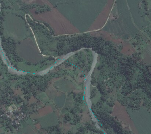
I have another problem regarding ArcHydro tool delineation. I have search for many literature regarding this particular case and find no concrete solution nor cause of these. One paper said that the area could be generally flat but i checked the DTM for the elevation and found out that it did not follow the river path even if the terrain it passed throught has higher elevation. These is no not an isolated case and it occurs in many delineation i did. Hoping for your response. Thank you very much. (I attached an image regarding the error in the delineation)
- Mark as New
- Bookmark
- Subscribe
- Mute
- Subscribe to RSS Feed
- Permalink
This is a problem in flat areas.
- One solution is to draw a polyline in the agreestream layer and then burn the streams in. This is my preferred solution.
- You only need to draw polylines where you need to "train" the DEM to be lower in elevation and make it follow the creek, stream, or river. Where the GIS drainage lines follow the river there is no need to burn in a stream.
- When you burn the stream into the DEM you basically lower the cells in the DEM that intersect the agreestream polyline. These can be burned very deep (1000 feet or meters) because one of the next steps is to fill the sinks. When you run the fill sinks tool, the local low cells in the DEM area filled up and the elevation of the cells that were burned low will be raise up to match the elevation of the lowest cell next to them. If the lowest cell is a cell in the DEM that has a "correct" stream elevation, then the burned cells will not be raise higher than that and you will then have a corrected DEM.
- This can be done at bridge and culverts where you have road crossings.
- When a DEM is corrected using stream burning and wall building, so that the flow direction is right, you have what is called a "hydrologically correct DEM"
- Another solution would be to build walls. I would not normally do this to correct a stream alignment problem.
- A "wall" could be drawn across the incorrect stream and force the flows to not flow there. This could be a solution for some cases and is commonly used in flat watersheds to stop water from "spilling" over low ridges or known flow barriers in the watershed.
- For example, I often draw a polyline along railroad tracks in an innerwalls layer. Then I put an agreestream polyline where the culverts go under the tracks. Burning the streams using the agreestream layer and then building walls using the agreestream layer for the breach layer, one can do a good job of training the DEM and working towards a hydrologically correct DEM.
- Another solution similar to the first solution is to use an existing stream/river layer and use it to burn in all the streams.
- I used to do this with our countywide creek layer. Then I found that many of the polylines in the creek layer were incorrect!. I will use it as a guide and occasional copy from it to my agreestream layer, but in general I do not trust it.
Hope this helps.
Mark