- Home
- :
- All Communities
- :
- User Groups
- :
- Web AppBuilder Custom Widgets
- :
- Questions
- :
- Re: LocalLayerWidget and AccessifizrWidget
- Subscribe to RSS Feed
- Mark Topic as New
- Mark Topic as Read
- Float this Topic for Current User
- Bookmark
- Subscribe
- Mute
- Printer Friendly Page
LocalLayerWidget Version 2.5 and AccessifizrWidget Layer - 09/28/2017
- Mark as New
- Bookmark
- Subscribe
- Mute
- Subscribe to RSS Feed
- Permalink
- Report Inappropriate Content
I've been having a blast playing around with the new Web AppBuilder, and have taken a few cracks at putting together some custom Widgets that I'd like to share with the community. I hope these can assist in everyone's future Mappmaking endeavours!
LocalLayerWidget
LocalLayerWidget v 2.5
September 28 2017 : LocalLayerWidget v2.5 released: This major release includes the following enhancements for the widget. Thanks to everyone who's donated!:
Release LocalLayerWidget 2.5 · cmndrbensisko/LocalLayer · GitHub
- Support for 2.5 Release of ArcGIS Web App Builder
- Support for Custom Layers via Transformers
- Demos and sample apps
- Prototype 3D Widget
- Dynamic GUI changes at runtime and css insertion via odds.json/odds.css
- And more!
November 14, 2016: LocalLayerWidget v2.2 released: This major release includes the following enhancements for the widget:
Release LocalLayer v2.2 · cmndrbensisko/LocalLayer · GitHub
- Related Table Viewing and Editing
- ImageService Viewing and Popups
- WMS Service Viewing and Popups
- Ability to integrate with the IncidentAnalysis widget
- Hide Layer In Legend capability added
- Dynamic mode added, allowing for URL-fed configuration files
- And more!
May 18, 2016: LocalLayerWidget v.2.0 released: This substantial change for Web App Builder v.2.0. removes the need to edit any core files in the Web App Builder, unlike previous versions. A slight change will still be necessary for the AttributeTable widget to work properly with LocalLayerWidget layers.
- https://github.com/cmndrbensisko/LocalLayer/releases/tag/v2.0
- Enhancements:
- Added autorefresh capability for dynamic layers, and sub-minute decimal values can be specified for time.
- Added support for non-consecutive sublayer numbering to support 10.3.1 mapservices
- Editor Tracking via an organizational Active Directory instead of ArcGIS Online User now supported
- Bug Fixes:
- View Attachments now works for Dynamic Layers
- Addition of GeoJson layers fixed
- Fix to MapService sublayer visibility when no sublayers are selected to display by default.
Mar 29, 2016: LocalLayerWidget v.1.3.1 released; Contains bugfixes to v.1.3. related to custom rendering for Feature Layers and toggling sublayer visibility in the LayerList widget.
Mar 22, 2016: LocalLayerWidget v.1.3 is now available! (Note the version naming change; Version 1.3 refers to its compatibility with v1.3 of the WAB - This is indeed the latest version of the widget as of March 22, 2016). Be sure to read the github page to see what tweaks need to be made to ensure that everything continues running smoothly in version 1.3 of the Web AppBuilder.
- Includes support for GeoJSON and WebTileLayers
- Custom Symbology and Labelling Options for Feature Layers
- Currently requires the use of playground to generate custom json layer and label styling for Feature Layers. For more information, please follow the instructions on the Github page.
Feb 10, 2015: LocalLayerWidget v.1.5 is now available! This release contains full support for adding Tiled layers to your application directly from ArcGIS Server, in addition to the Basemap, Dynamic, and Feature layers available before. Feel free to grab the widget from our Release page located at https://github.com/cmndrbensisko/LocalLayer/releases.
Feb 2, 2015: LocalLayerWidget v.1.2 is now available! This release provides a great GUI developed by Robert Scheitlin to more easily add Feature, Dynamic, and Basemap layers to your ArcGIS Web AppBuilder Applications. Take it for a spin, and please keep us informed of any bugs or desired enhancements through our Github Issue Tracker located at https://github.com/cmndrbensisko/LocalLayerWidget/issues.
Jan 12, 2015: Note that LocalLayerWidget v.1.1 is now available, which provides Click-To-Identify support and the option to add Feature and Basemap layers in addition to Dynamic layers.
The LocalLayer Widget is intended to allow the direct addition of MapServices to an ArcGIS Web AppBuilder application, without needing to wrap the desired services in an ArcGIS Online/Portal Web Map.
https://github.com/cmndrbensisko/LocalLayerWidget
Basically, your basemap will still need to come from Portal/AGOL, but otherwise you just provide direct URLs to your own MapServices in the widget's configuration settings. The MapServices should load and display as usual in the map, and cooperate with the Legend, LayerList, and Attribute Table widgets. Click-To-Identify functionality won't work currently, though, because the current WAB implementation relies on Portal for all the popup info. As stated in the January 12th 2015 release, popups are fully customizable. Note that it's not an in-panel widget, so you'll need to follow a few extra steps in the project's Readme file.
AccessifizrWidget
Let's make Mapps accessible for everyone! With an eye on WCAG compliance, the Accessifizr Widget is designed to help make web applications keyboard navigable without having to modify core application code and UI.
https://github.com/cmndrbensisko/AccessifizrWidget
Information about how to configure this widget is available in the core Accessifizr.js library project available here, but the gist is that you create a JSON-based 'roadmap' detailing the keyboard navigation of your web application, and how it should change in response to users entering modal menus, hitting the escape button, etc. For applying descriptive alternate text to page elements, the widget leverages dojo's built-in internationalization support to specify multilingual alternate text strings. The end result is a web app that, hopefully, is a bit easier to use for people with mobility or visual challenges.
- Mark as New
- Bookmark
- Subscribe
- Mute
- Subscribe to RSS Feed
- Permalink
- Report Inappropriate Content
All signs point to the Coordinate Widget causing the problems...but only when a non default coordinate system is used.
- Mark as New
- Bookmark
- Subscribe
- Mute
- Subscribe to RSS Feed
- Permalink
- Report Inappropriate Content
It looks like there is one more incompatibility that I am running into. It appears that the location widget resizes the popup window to about 1/2 to 1/3 the original size. Everything appears to work fin until that point.
- Mark as New
- Bookmark
- Subscribe
- Mute
- Subscribe to RSS Feed
- Permalink
- Report Inappropriate Content
Nick,
The Coordinate widget issue is a known one and has nothing to do with the Local Layer Widget:
- Mark as New
- Bookmark
- Subscribe
- Mute
- Subscribe to RSS Feed
- Permalink
- Report Inappropriate Content
- Mark as New
- Bookmark
- Subscribe
- Mute
- Subscribe to RSS Feed
- Permalink
- Report Inappropriate Content
Unable to add cached image service as Tiled Map (Invalid Tiled Map Service URL error)
ArcGIS Server 10.2.2, WAB 1.1, LL 1.5.1
Is this by design?
Thanks
Subu
- Mark as New
- Bookmark
- Subscribe
- Mute
- Subscribe to RSS Feed
- Permalink
- Report Inappropriate Content
Subu,
Currently Image services is not a supported layer type.
- Mark as New
- Bookmark
- Subscribe
- Mute
- Subscribe to RSS Feed
- Permalink
- Report Inappropriate Content
Thanks Robert for the response and for all your work in helping the community.
I would like to suggest that the documentation for the LocalLayer widget could be improved - by adding notes such as your response to the Github site.
Subu
- Mark as New
- Bookmark
- Subscribe
- Mute
- Subscribe to RSS Feed
- Permalink
- Report Inappropriate Content
Robert,
Are there any plans to make KML/KMZ services a supported layer type?
- Mark as New
- Bookmark
- Subscribe
- Mute
- Subscribe to RSS Feed
- Permalink
- Report Inappropriate Content
Daniel,
I have not current plans in place but I will add this as an possible enhancement.
- Mark as New
- Bookmark
- Subscribe
- Mute
- Subscribe to RSS Feed
- Permalink
- Report Inappropriate Content
Adam and Robert,
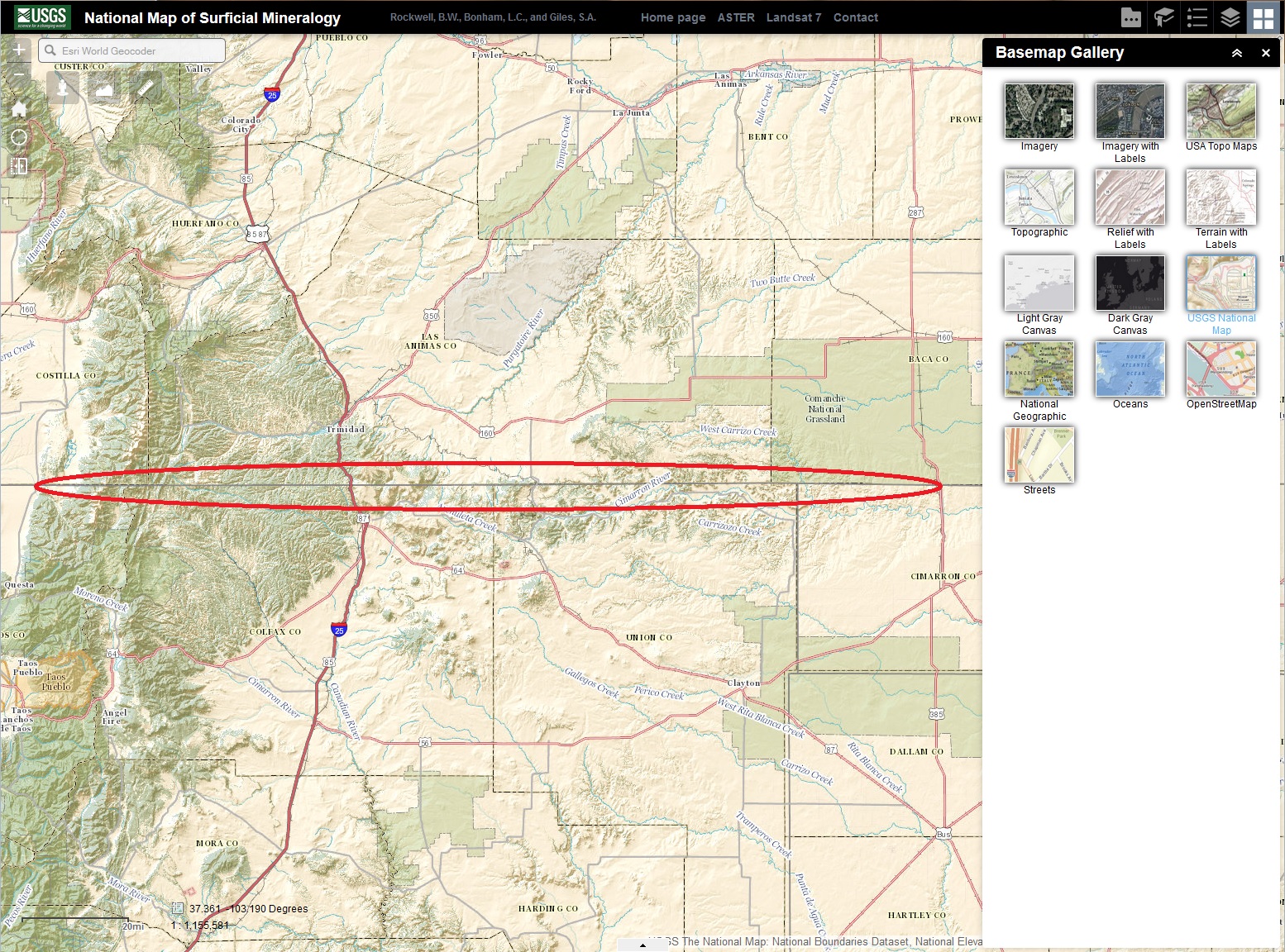
I believe that I am still getting incorrect layer display in complex layering situations depending on whether layers are on or off in the published mxd and/or whether the (dynamic) layer is on or off by default in the WAB Dev 1.1 app.
The issue can be seen in this app
in the "ESRI 2013 Geographic Data" dynamic vector layer at the top of the layer list, added using the Local Layer widget (v1.5.1). This layer is turned off by default in the WAB app. Note that service is NOT tiled.
This shot shows an area crossed by a state boundary (highlighted in red):
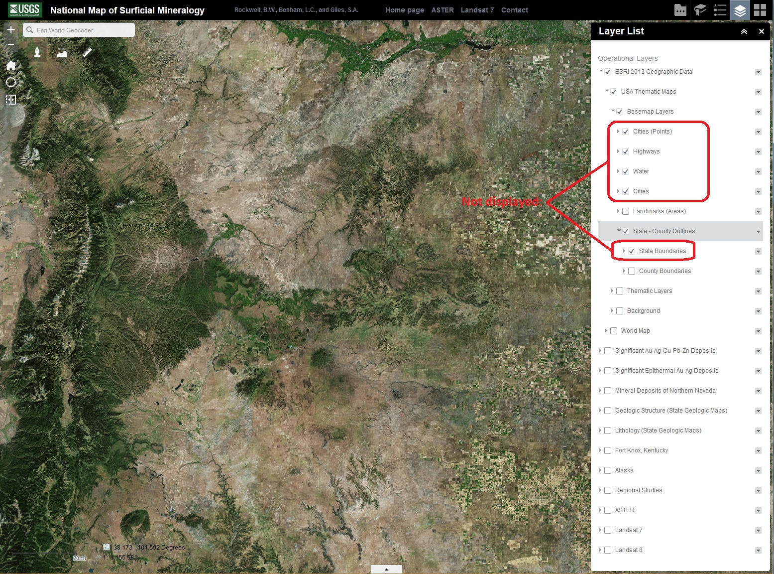
This shot shows the TOC in the Layer List widget and the incomplete display of layers. All I have done here is turn on the "ESRI 2013 Geographic Data" layer, turn off the Landsat 7 layer, and turn off the ESRI 2013 Geographic Data/World Map layer. Note that none of the layers under ESRI 2013 Geographic Data/USA Thematic Maps/Basemap Layers are displaying even though they are turned on by default in the mxd (shown by checked layers in the TOC).
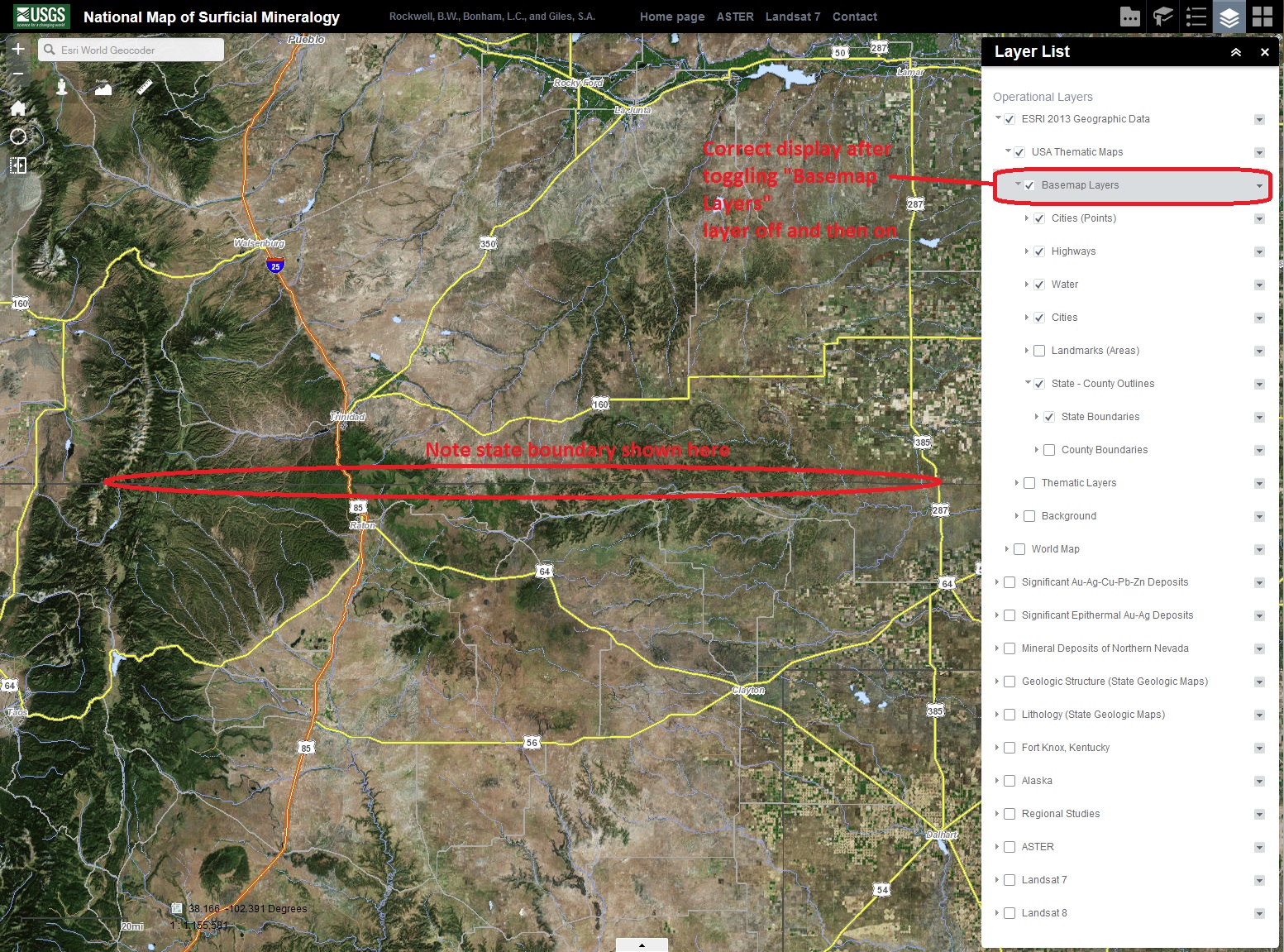
Here is a shot showing correct layer display that occurs after I have toggled the "Basemap Layers" layer in the service off and then on.
I think you should be able to duplicate this issue by trying out my WAB app. The issue does not occur in a Flex viewer using the same services:
National Map of Surficial Mineralogy
Let me know if you need more info.
Best regards,
Barnaby