- Home
- :
- All Communities
- :
- Products
- :
- Mapping and Charting Solutions
- :
- Mapping and Charting Questions
- :
- Re: Creating A Raster Dataset
- Subscribe to RSS Feed
- Mark Topic as New
- Mark Topic as Read
- Float this Topic for Current User
- Bookmark
- Subscribe
- Mute
- Printer Friendly Page
Creating A Raster Dataset
- Mark as New
- Bookmark
- Subscribe
- Mute
- Subscribe to RSS Feed
- Permalink
I am relatively new to ArcGIS, and am creating a map for the water/sewer utility that I work for. I have a geodatabase created, but need to add my raster. This map is going on our Windows mobile device that does not have internet access, so I can't just use a Basemap from ESRI. I have 120 individual mosaic Sid tiles that I would like to add. What would be the best way to go about this? I didn't know if I should create a raster dataset with the toolbox, or create a layer package from the Table of Contents... or something completely different.
- Mark as New
- Bookmark
- Subscribe
- Mute
- Subscribe to RSS Feed
- Permalink
Hi Alex,
You may want to create a mosaic dataset for your raster data using the Mosaic Dataset toolset. You will first create an empty container in the gdb and then add your raster images.
Creating a mosaic dataset:
- Mark as New
- Bookmark
- Subscribe
- Mute
- Subscribe to RSS Feed
- Permalink
If you intend to use the image only as a background, i would mosaic it into a single raster dataset and save it inside the file geodatabase. mosaic datasets are slower and unless you create overviews, viewing the total extent of your 120 sids would need a bit more tweaking with your mosaic dataset properties.
- Mark as New
- Bookmark
- Subscribe
- Mute
- Subscribe to RSS Feed
- Permalink
As Mike stated, after overviews are built, a mosaic dataset will perform faster than a single raster dataset. Creating a mosaic dataset takes a fraction of time to create, and also saves a tremendous amount of disk space. Especially when dealing with SID images. SIDs are highly compressed, so when you mosaic them to a single raster dataset, they will become uncompressed. A SID that is only 3 MBs on disk, may be over 60 MBs when it's uncompressed. A mosaic dataset will read the raw SID files and not have to uncompress them. I would recommend using a mosaic dataset.
- Mark as New
- Bookmark
- Subscribe
- Mute
- Subscribe to RSS Feed
- Permalink
Based on my experience working with aerial orthophotos, a single (mosaic) raster dataset will always display faster than a mosaic dataset under most circumstances, with or without overviews. (It does take a whole lot of time to create them and may not be practical in all situations, but in this particular case with only 120 SIDs, it should not take too much time) If you save the single (mosaic) raster dataset in a file geodatabase with the same compression settings as your original SIDs, there would be very little difference in terms of size compared to all your 120 SIDs (plus the size of the overviews) on disk. The only reason I would use a mosaic dataset is if I want to use the extra functions that goes with it. If you use it only for displaying as a basemap, I will stick with the single (mosaic) raster dataset.
And raw SIDs will always be uncompressed whenever it is read even when in a mosaic dataset. Which makes the overviews very important since zooming out to smaller scales means it needs to uncompress more SID tiles unless an overview has been created at that scale in which case it displays the overview (which is actually made up of a couple of raster datasets resampled to larger pixel sizes).
- Mark as New
- Bookmark
- Subscribe
- Mute
- Subscribe to RSS Feed
- Permalink
SIDs use wavelet compression, which is not a supported compression type that ArcGIS can write to. JPEG 2000 compression, which is a supported compression type, uses wavelet technology to compress rasters, however if you want to achieve a lossless compression, you cannot use this method within a file geodatabase or ArcSDE geodatabase. For file geodatabases and ArcSDE geodatabases, you would want to use LZ77. See the following link for more information.
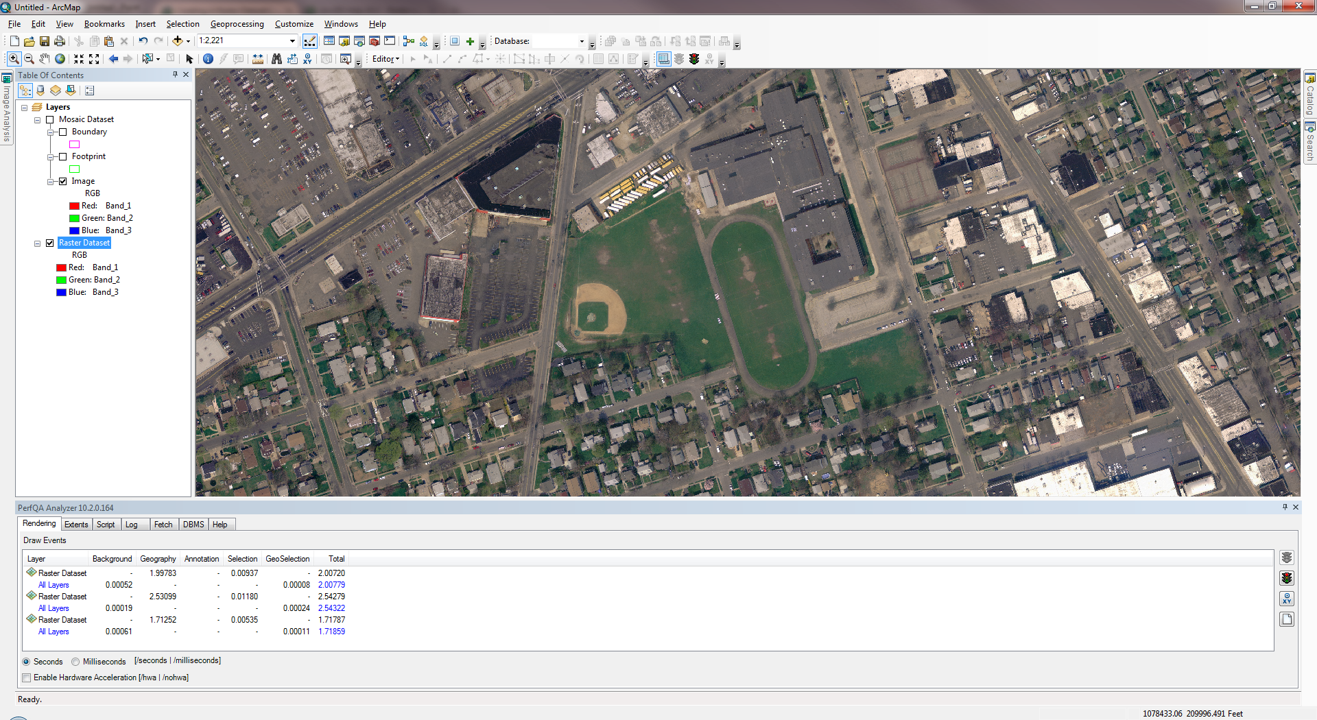
I've also attached a PPT for a presentation I had to give comparing the storage of a raster dataset vs a mosaic dataset. The source data is 130 SID images that are each 3.5 MBs on disk (66 MBs uncompressed). The PPT demonstrates the time and storage saved using a mosaic dataset rather than a raster dataset. Note: raster dataset is stored with LZ77 compression.
Also, here are some screen shots comparing the raster dataset and mosaic dataset using the PerfQAnalyzer (same data, but the raster and mosaic dataset both reside in a File Geodatabase).
Raster Dataset:
Mosaic Dataset:
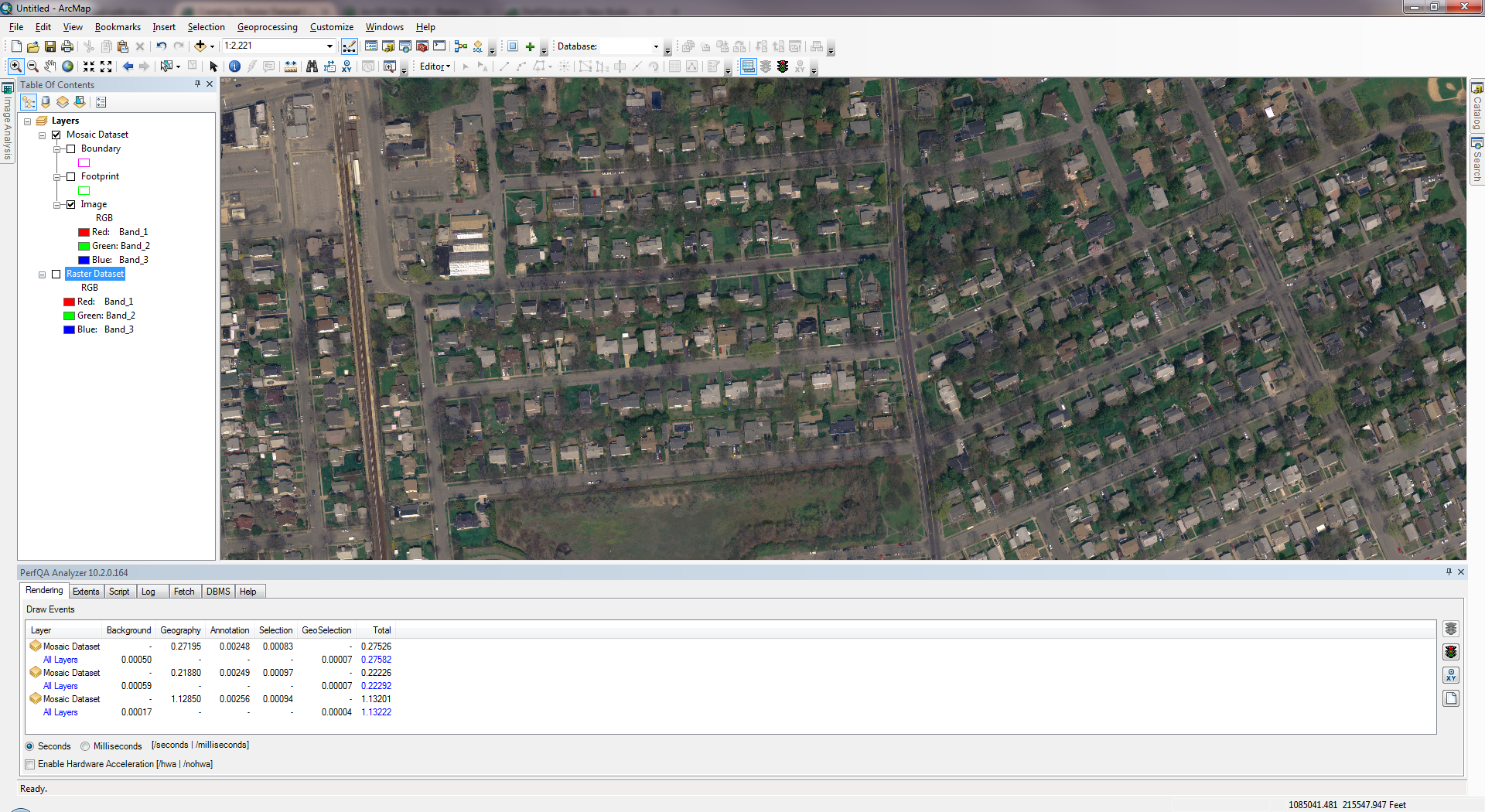
You can see the mosaic dataset renders faster (performed 3 zooms for each dataset).