- Home
- :
- All Communities
- :
- Products
- :
- ArcGIS Pro
- :
- ArcGIS Pro Ideas
- :
- Insert new feature on a specific user-defined loca...
- Subscribe to RSS Feed
- Mark as New
- Mark as Read
- Bookmark
- Follow this Idea
- Printer Friendly Page
Insert new feature on a specific user-defined location on edit
- Mark as New
- Bookmark
- Subscribe
- Mute
- Subscribe to RSS Feed
- Permalink
our organization that works alot with planning maps and sketches for decision makers are missing the ability to insert a geometry (feature) in a user specifik place while editing, and importing data let me explain what im looking for.
what if:
- as a user, you got the ability to do a template geometry that u later can use while editing to insert in your map by just clicking once in the map.(like an symbol but it adds a polygon or line defined geometry, depending on your featureclass)
- Your able to set an insertion point if needed when u import/append/paste features. and the feature adds depending on the insertion point
these 2 new abilites would help us alot and save us time and money while were sketching for new zonal or residential areas, we could have ready to go standard building footprints, parking lots, and other geometrys to add to our map by one click away. The user wouldnt need to be a pro GIS user if they just wanna sketch if the project is already configured.
as it is now we have "sort of" these abilities in our CAD system but we want to move from CAD to GIS fulltime!
You can probably get pretty close to what you're asking here by using Preset templates: Create a preset template—ArcGIS Pro | ArcGIS Desktop
You can definitely create a preset template based on a selection of one or many different features (points, lines, polygons) so that when editing, you can just use that template to drop the group of new features in place.
When inserting a new feature or features from the preset template into the map, you can specify an absolute x,y,z to place it in a specific location.
If you needed to adjust it afterwards, normal editing techniques could be used.
After reviewing the Preset Template help and working with it, can you respond here with whether this meets the request, and if not, what functionality would help your work?
Thanks
Thx Kory!
First of all, I didnt think any ESRI personel would even bother to look at this post, so for that im really pleasantly surprised that I got an reply  , and also that fast!, thank u!
I think this might be just what were looking for, I have only one issue and thats were only using arcmap for now since our 3rd party software to include the swedish planning standard is written only for arcmap right now. I hope it will be rewritten ASAP for arcGIS pro 
although, the sketch part might be able to be done in arcGIS pro, if so then I just have to convince my coworkers to use it.
No problem - I like to try to provide solutions or workarounds that keep people moving forward today, even if there still is room for improvement in functionality
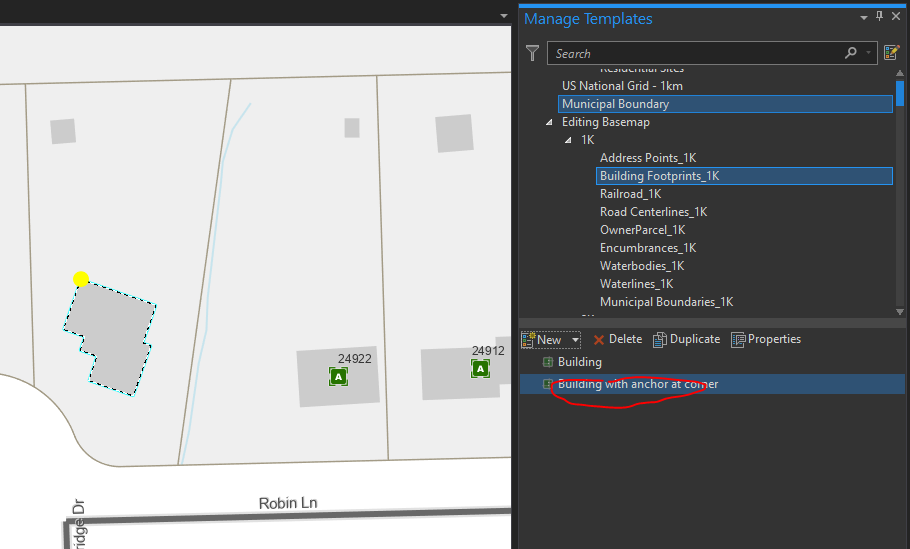
After working a bit more with the editing team yesterday, I found that we can tweak the preset template a little bit during the creation process by placing the anchor point where we want. So, for example, if I know that my workflow will require me to snap a building corner to another feature, and then rotate around that anchor, I could place it before creating the template and the template will honor the anchor location.
- Before creating the preset template, select the features and open the Move tool. Notice the yellow anchor.
- Hold CTRL and drag the anchor to where you want the origin/snap point of the preset template to be.
- Create the preset template normally.
- Now create a new feature using the template and you will notice the new features can be snapped using this location.
This experience is one that the team has in the backlog to address, but it hasn't bubbled up as a very high priority yet in the development process (because it's essentially a difference of whether you're controlling the placement and orientation before or after dropping the feature).
I completely understand that the organization as a whole may not be ready to move to ArcGIS Pro, but like you said, as you can show these types of improved workflows, maybe it will help convince your co-workers... You'll be the internal champion!
Hope this helps.
At 2.6, we added the ability to specify the insertion point of preset templates:
Not requested here, but coming soon in 2.7, you will be able to rotate the preset features during creation using the new Point with Rotation tool.

You must be a registered user to add a comment. If you've already registered, sign in. Otherwise, register and sign in.