- Home
- :
- All Communities
- :
- Products
- :
- ArcGIS Enterprise
- :
- ArcGIS Enterprise Ideas
- :
- Better layout or GUI for AGOL/Enterprise file mana...
- Subscribe to RSS Feed
- Mark as New
- Mark as Read
- Bookmark
- Follow this Idea
- Printer Friendly Page
- Report Inappropriate Content
Better layout or GUI for AGOL/Enterprise file management for Collaboration
- Mark as New
- Bookmark
- Subscribe
- Mute
- Subscribe to RSS Feed
- Permalink
- Report Inappropriate Content
I am working a lot between AGOL and Enterprise and I am having a really hard time keeping things straight in my head in between where I am keeping files, view, and what groups I have as well as what items I have in collaborated content and am experiencing a lot of syncing issues between agol and enterprise. I am finding it very troublesome to visualize how all my files are laid out, what groups they are all in, and whether preforming a certain action would break a webmap feeding to an application. It seems like I am spending more and more time clicking through EVERY SINGLE LAYER and EVERY SINGLE GROUP. When all I want to do is look at a windows explorer or ArcCatalog like piece of software. The fact that I can't have subfolders is killing me and not being able to navigate through my folders in Map Viewer Makes it difficult to find items sometimes.
Please tell me that there is either a better way to manage my files or that you all are working on something that would make it less troublesome to visualize all of my files, groups and collaborations.
- Mark as Read
- Mark as New
- Bookmark
- Permalink
- Report Inappropriate Content
Hi Walter,
Thanks for raising this topic! We had the chance to meet in more detail last year but I wanted to post a few recent updates for those circling around similar topics. We definitely welcome other ideas on how to make content management more streamlined and easier for all. We’ll be releasing a whitepaper in the next few weeks that touches on this topic and can be used as a reference guide.
A few recent updates:
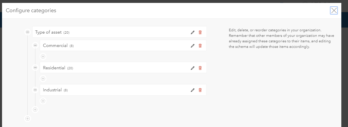
Content categories
Content categories categorize your items around shared themes. Categories can be used when filtering and searching content. An example of setting up categories:
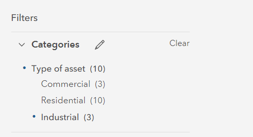
And how they appear as a filter:
More information on categories:
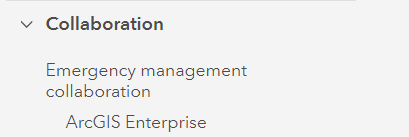
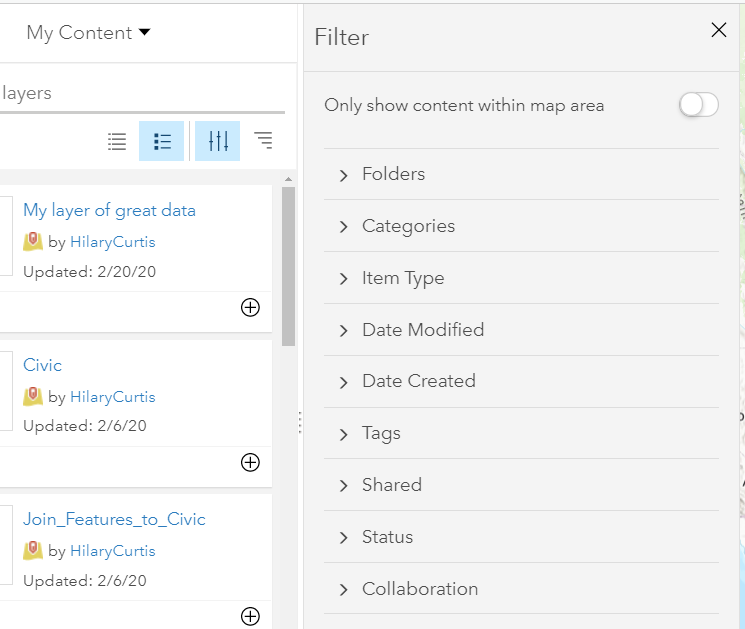
Collaboration filter
For organizations using distributed collaboration, we recently added a collaboration filter to make it easier to manage collaborated content. Using the filter, you can determine which collaboration the data is a part of and where the data came from:
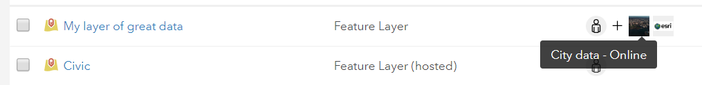
Collaboration badge
Starting in recent releases, all content received from other organizations will display a collaboration badge. This is helpful when looking through and filtering items on the Content tab and adding data to a map – we had a lot of requests that this would help identify the items that are coming from another organization vs. your own:
![]()
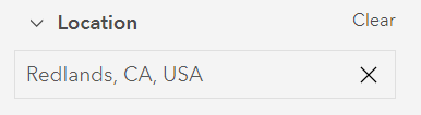
Location filter
The location filter is new as of 10.7.1 and returns items located in that specific place or region:
Updated experience for adding data to a map
It’s now easier to find the right data to use on a map - you can use these different filters and badges and categories to find what you need:
Authoritative and deprecated badges
Authoritative and deprecated badges can signal to other users if content is authoritative (up to date, vetted, approved) or deprecated (not to be used in active maps/apps).
Update to sharing icons:
A recent update in ArcGIS Online that will be coming to ArcGIS Enterprise is the ability to see more specifics on the sharing settings of an item – now instead of just “groups”, you can see the specific group icons and names:
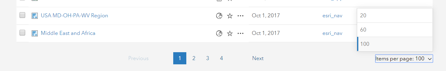
Increase the number of visible items
On the Content tab, we’ve added an option to increase the number of items displayed on the table/list/grid view (configurable at the bottom of the Content tab):
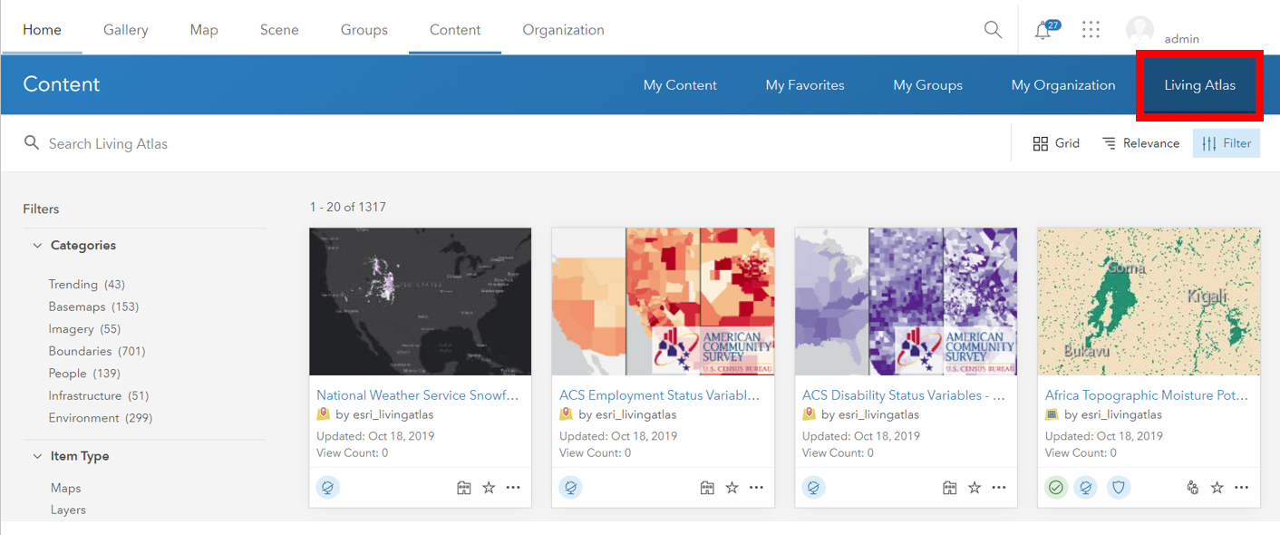
Moved Living Atlas content
To make it possible to browse just your organization’s content but still use Living Atlas, we’ve separated Living Atlas content in its own tab:
Disable external content
For organizations who do not want to display/use Esri-created items in their Enterprise portal, there is an option to disable external content which removes:
- Basemaps owned by "esri_[lang]"
- Content owned by "esri_nav"
- Content owned by "esri"
Something that is top of the list for many is to trace which items/data/services are used in which maps/apps. GeoJobe has some great extensions (Admin Tools and Clean My Org) that can help with this and general content management organization/clean up.
If others have tips on how they have organized content in ArcGIS Enterprise and ArcGIS Online, feel free to post here - also if you have ideas on how we can continue to improve this experience.
Thank you!
You must be a registered user to add a comment. If you've already registered, sign in. Otherwise, register and sign in.