- Home
- :
- All Communities
- :
- Industries
- :
- Water Utilities
- :
- Water Utilities Documents
- :
- Prototype Utility Network Data Model for Irrigatio...
- Subscribe to RSS Feed
- Mark as New
- Mark as Read
- Bookmark
- Subscribe
- Printer Friendly Page
Prototype Utility Network Data Model for Irrigation Districts
Prototype Utility Network Data Model for Irrigation Districts
This prototype data model is provided to help irrigation districts get started with a utility network. The prototype data model was developed by Esri as a research project in collaboration with two irrigation districts. One of the irrigation district uses a gravity feed irrigation network in a predominantly agriculture area, the other irrigation district operates a gravity feed irrigation system in a predominately suburban area.
The Prototype Irrigation Data Model is for gravity feed irrigation systems. It is not designed to represent pressurized non-potable irrigation systems. For those systems we recommend starting with the Water Utility Network Foundation.
The first prototype borrows many data elements from geometric network based pipe system data models. We hope more irrigation districts can review the prototype and share feedback on the design and inclusions.
As time permits, we plan to continue development of the prototype. Please post comments and feedback here.
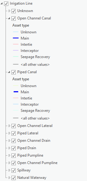
Here are some basic modeling principles
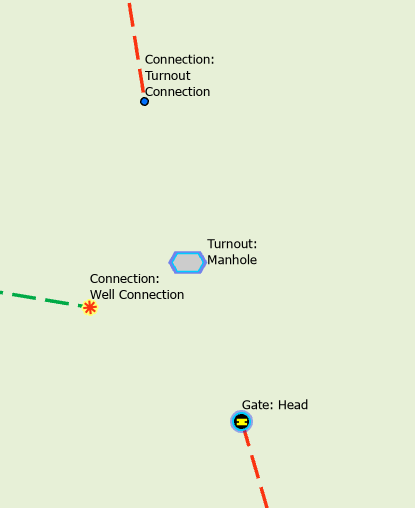
- Pipes and Canal are divided into different Asset Group and Asset Types by their function
- Turnouts are Structure Junctions and contain Gates and other features
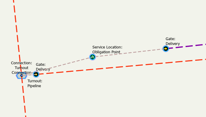
- Delivery Gates offset from the lateral using a connection point so their status does not affect flow on the lateral
Components in this download
- Asset Package based on ArcGIS Pro 2.5
- Editor Map
Status
- Asset Groups and Asset Types created
- Core set of rules
- 3 Tiers - Canal, Lateral and Forebay
- Simple basic set of Attributes
- Basic set of sample data
Gaps
- Attribute domains and specific set of attributes per Asset Group
- Complete set of rules for connectivity
Rives,
The model is provided as a prototype or proof of concept to show how the Utility Network supports irrigation systems. There are currently no plans to move this model to a supported solution.
Hey @MikeMillerGIS ,
Finally digging into this head first. For irrigation lines are the upelev, dwnelev, and slope fields required?
In general what are the required fields moving forward?
We are going through field organization and clean up right now, and I want to make sure that I set up the data loading spreadsheets up appropriately.
Thanks.
Brian Colson, GISP
For irrigation lines are the upelev, dwnelev, and slope fields required?
- No these are not required. Just thought it might be good to monitor slope
In general what are the required fields moving forward?
- Only Asset Group and Asset Type are really required. There are fields assigned to Network Attributes, these are required if you want to model opening/closing a gate in a trace
Thank you @MikeMillerGIS .
We have learned that our elevation fields are not very accurate, and therefor we don't want to cause more confusion moving forward. Thank you for the clarification on the fields that are required.
I appreciate the reply, and may have more questions in the coming weeks. 🤓
Brian Colson, GISP
Hello @MikeMillerGIS
Curious if the irrigation district UN data model prototype was ever expanded or added as part of a UN foundation?
Thanks,
Brian Lendt
@BrianLendt1 We have not done any additional work on the model. I know a few districts have started with it as a baseline.