- Home
- :
- All Communities
- :
- User Groups
- :
- Conservation GIS
- :
- Documents
- :
- Scgis 1997 Founding Board Member: Sandra Coveny
- Subscribe to RSS Feed
- Mark as New
- Mark as Read
- Bookmark
- Subscribe
- Printer Friendly Page
Scgis 1997 Founding Board Member: Sandra Coveny
Scgis 1997 Founding Board Member: Sandra Coveny
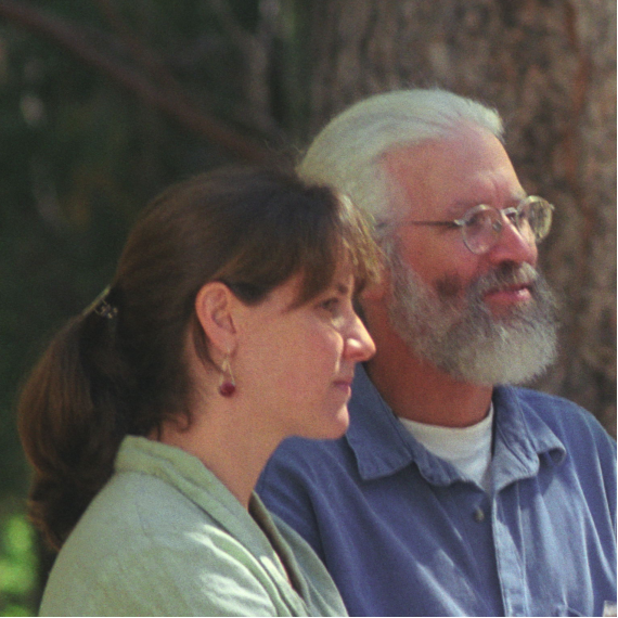
1997: Sandra Coveny, Oregon Coast Range Association OR
Sandra leading sessions with Michael Hamilton at the first official SCGIS conference in 1997
in the San Bernardino National Forest (photo C. Convis)
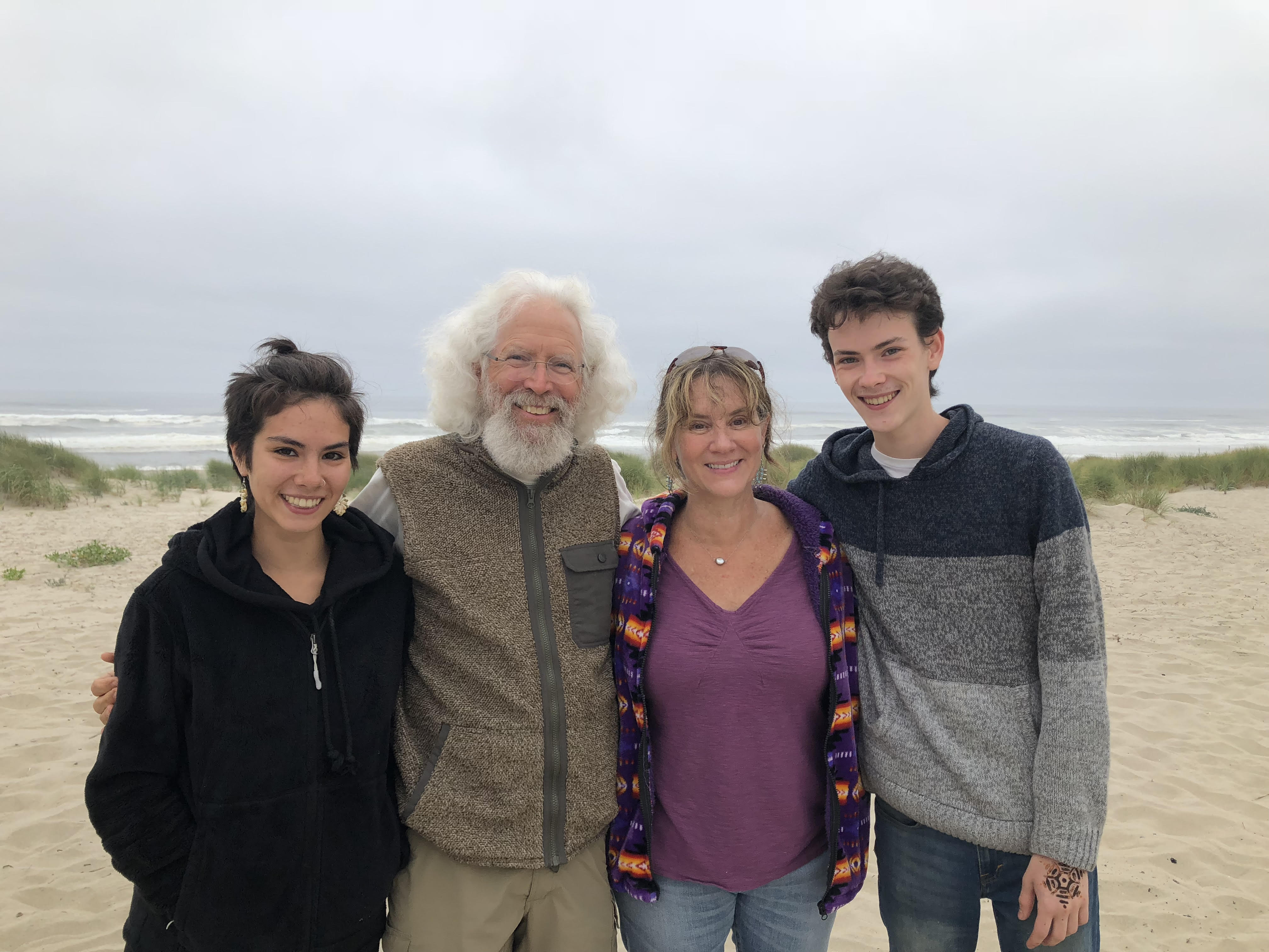
2019: Sandra (photo, below) on the Oregon Coast at Waldport, with visiting friend Michael Hamilton and children Kiyomi (R) and Adin (L). Adin is a second-generation SCGIS volunteer!
He joined the Camera & Documentary crew of the 2018 SCGIS Conference.
2019: Sandra relates her story of she became involved with SCGIS:
“I first learned about the conservation GIS community and about Esri’s conservation program in 1991 as a first year graduate student after I published an article in Wild Earth journal explaining the benefits of using GIS for conservation. Having been on the front lines of the spotted owl controversy in the Pacific Northwest (and using mylar overlays on USGS maps to draw in owl habitat and monitor timber sales), I wanted to continue being an activist, but gain scientific and technological background to benefit conservation efforts. The target audience for my article, and the journal itself, was both activists and luddites. Therefore, the article was called “GIS: What it is: Technology is not entirely Evil”. I was hoping the conservation community and organizations would adopt GIS as a tool of their trade.
I was also hoping to use GIS in my My master’s thesis, but my school did not have the software at that time. My thesis was about conserving biodiversity on a large scale, and I was hoping to use GIS to design a large ecological reserve that encompassed the entire landscape - including private property. In those days conservation was practiced on public lands only, and it was unthinkable (actually my graduate committee laughed at me when I proposed it) to consider adding information about private property to the conservation matrix at a large scale - mainly because … property rights. There was an anti-environmental movement taking place called the “Wise Use” movement, which was basically a fake green cover for unhindered natural resource extraction. My graduate work was funded through a grant from Edward Abbey’s foundation, and David Foreman, head of the Wildlands Project (formerly head of Earth First!) was one of my mentors. Dr. Reed Noss, a noted conservation biologist, was on my committee. I worked with the likes of Michael Soulé and Society for Conservation Biology board members, as well as getting to meet Sierra Club and Friends of the Earth founder David Brower. I worked with a large group of activists up and down the east coast who were all focused on making the national forests more ecologically friendly.
Shortly after my article came out, I was grading papers from the conservation biology class I was teaching to undergraduates, when I received a phone call from a man called Tim Bechtold. Tim was the director of the Ecology Center in Missoula Montana at the time. Tim called me on the telephone (a landline in fact - remember those?) He said there was a guy named Charles Convis who was giving out passes to the Esri conference and that if I went to the conference in Palm Springs I was sure to meet other people like me, and might even get a grant of GIS software for my work, if I was lucky. My wish for using technology and GIS to fight the evil resource extraction industry might just come true. I applied for, and received a travel grant from my school to fly to Palm Springs, and took the offer of the free pass to the Esri conference from Charles.
Being a poor graduate student, I was unable to afford a room at the hotel where the conference was being held, so I went along with the other conservation folks and camped out in the mountains at the James San Jacinto Mountain Reserved owned by UC Riverside, managed by Dr. Michael Hamilton. There were many folks there who were working on similar projects to mine, and the conversations at the reserve were some of the most helpful when it came to my graduate research! The next year when I returned to the same conference and venue, Charles said he was hoping to turn the conservation GIS group into a non-profit, and maybe have a few days before or after the Esri conference to network amongst ourselves. Having formed several non-profits myself by this point in my career, I offered to do the legwork of forming the non-profit and organizing the conference.
Since then I have used GIS as the main tool of my trade.
2019 Professional Link: https://www.linkedin.com/in/sandracoveny/
Professional history
2018-Present: Watersheds, Climate and Soils Scientist at Confederated Tribes Warm Springs, Oregon
2014-2018
- Prepared Climate Adaptation Plan and Drought Response Plan Guidance Document for State of Montana (together with Emily Geery, contract with SWCA Inc)
- Editor, GIS lead for Forever Wild, LLC
- GIS / Strategic planning support for Forever Wild Seafood: Developed simple Storymap as outreach effort to save Bristol Bay from the Pebble Mine https://arcg.is/1GCDqf
- Project Lead: Climate Change Resiliency: Watershed Analysis - North Santiam Watershed Council.
2009 -2014 Natural Resource Planner PC Trask and Associates Landscape-Scale Restoration, Columbia River Estuary Salmon restoration project prioritization for Bonneville Power Administration; Army Corps of Engineers Climate Change project planning, GIS manager, project manager.
1997-2009 Executive director, Marys River Watershed Council, Corvallis Oregon — 1997-2009
As one of the first watershed organizations so fully integrate GIS into our planning and analysis efforts, I directed efforts to create a connected network of private properties, which have since connected with County parks, and the whole effort was used as Raised over $4m for watershed restoration projects for small watershed council, developed, and managed all projects, contractors and staff. Won state-wide recognition as Model Watershed, Pilot for integration of Watershed Restoration and K-12 education, and StreamNet Pilot for (then) Oregon Trout. Won Governors award (and selected for Oregon Solutions) for our Landscape-scale community restoration project in Cardwell Hills Community.
1993-present International Society for Conservation GIS (SCGIS) Co-founder, Advisory Board
SCGIS is a volunteer run organization dedicated to facilitating international conservation efforts, promoting high standards for data development and analysis, and information exchange among individuals using GIS for conservation. In 1997 and 2014 led the organization through a re-visioning and organization-wide strategic planning efforts.
As first Co-President of the organization, helped secure endowments to sustain programs. 1997 incorporated the organization as a federally recognized non-profit organization (501 (c) (3) ), and helped facilitate the formation and implementation of the organizations committees. Organized the first two annual international conferences. Developed investment strategy for endowments.
Chair: Conference committee 2015-17
Chair: domestic scholarship committee 2000-2004
Board of Directors: 1996-2001; 2013-2016
Current Member: international scholarship committee, membership committee, conference committee.
-
 Anonymous User