- Home
- :
- All Communities
- :
- Industries
- :
- Natural Resources
- :
- Petroleum
- :
- Petroleum Blog
- :
- Building Value at the Esri Petroleum GIS Conferenc...
Building Value at the Esri Petroleum GIS Conference
- Subscribe to RSS Feed
- Mark as New
- Mark as Read
- Bookmark
- Subscribe
- Printer Friendly Page
- Report Inappropriate Content
Esri Petroleum GIS Conference attendees discovered new ways to get business intelligence from their data, that drives planning and delivers greater profits.
The trendy words that buzzed around the halls of the Esri Petroleum GIS Conference 2018 came attached to data and lots of it: Big Data, Analytics, Digital Twin, IoT, AI . . . evidence that the industry is transforming itself through connected systems that extract business value from digital data. This data is building the muscles of the beleaguered O&G and pipeline industry and helping it climb out of a 4-year lull. More than 1100 attendees came to Houston this May, and were intensely focused as they explored new methods and technologies that would support their companies’ geospatial needs well into the future.
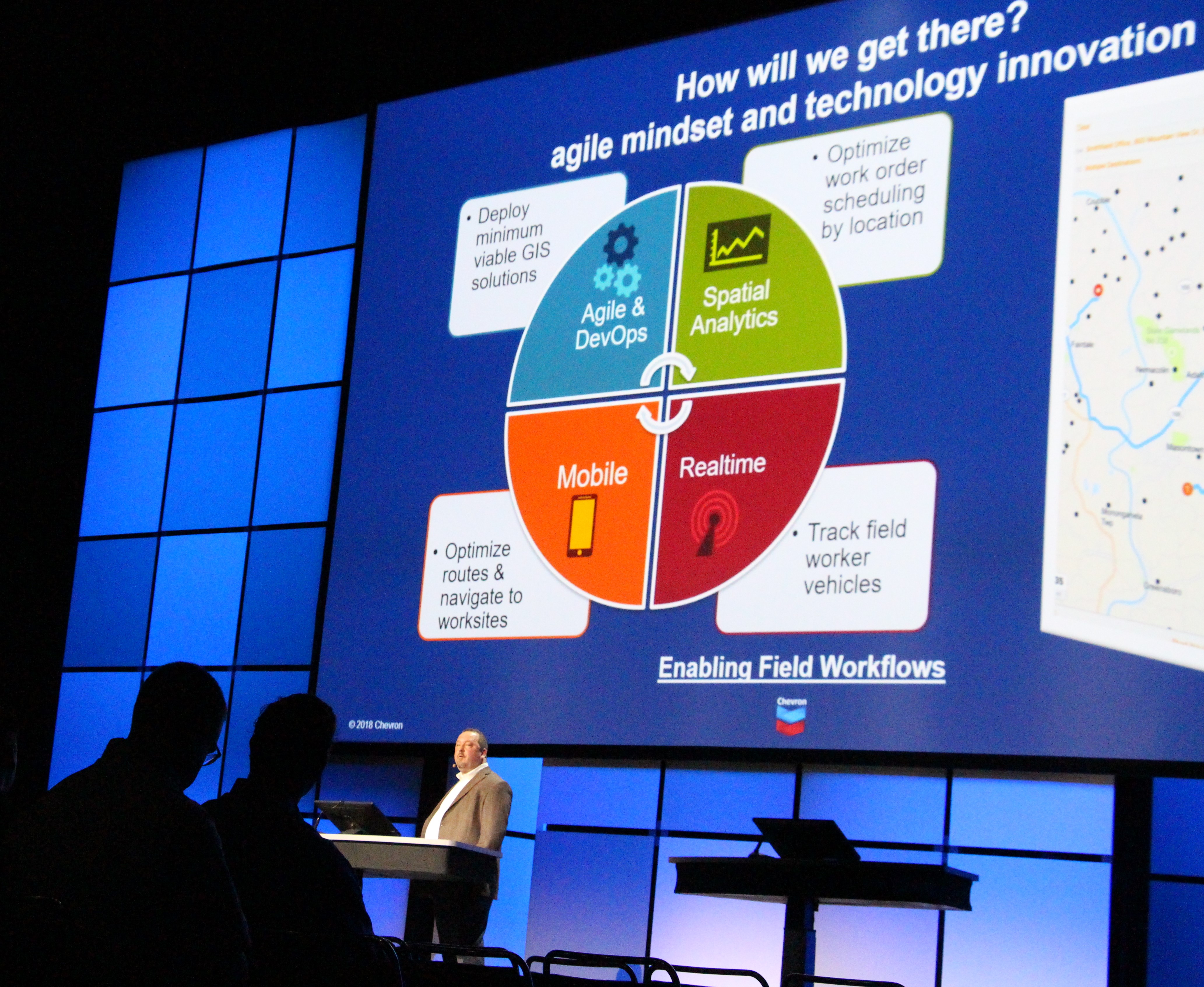 During the plenary, Esri handed the mic to petroleum company leaders who described how their enterprise digital transformation strategies and modernized methodologies were giving their companies an edge. For instance, Chevron demoed the newly launched Chevron Map Hub. Nearly 2500 employees use a combination of ArcGIS Enterprise and managed cloud services to easily find and access enterprise data, and perform cross-functional data analyses. Other companies explained how they had aligned their location strategies with their companies’ objectives in areas of mobility and operational efficiency.
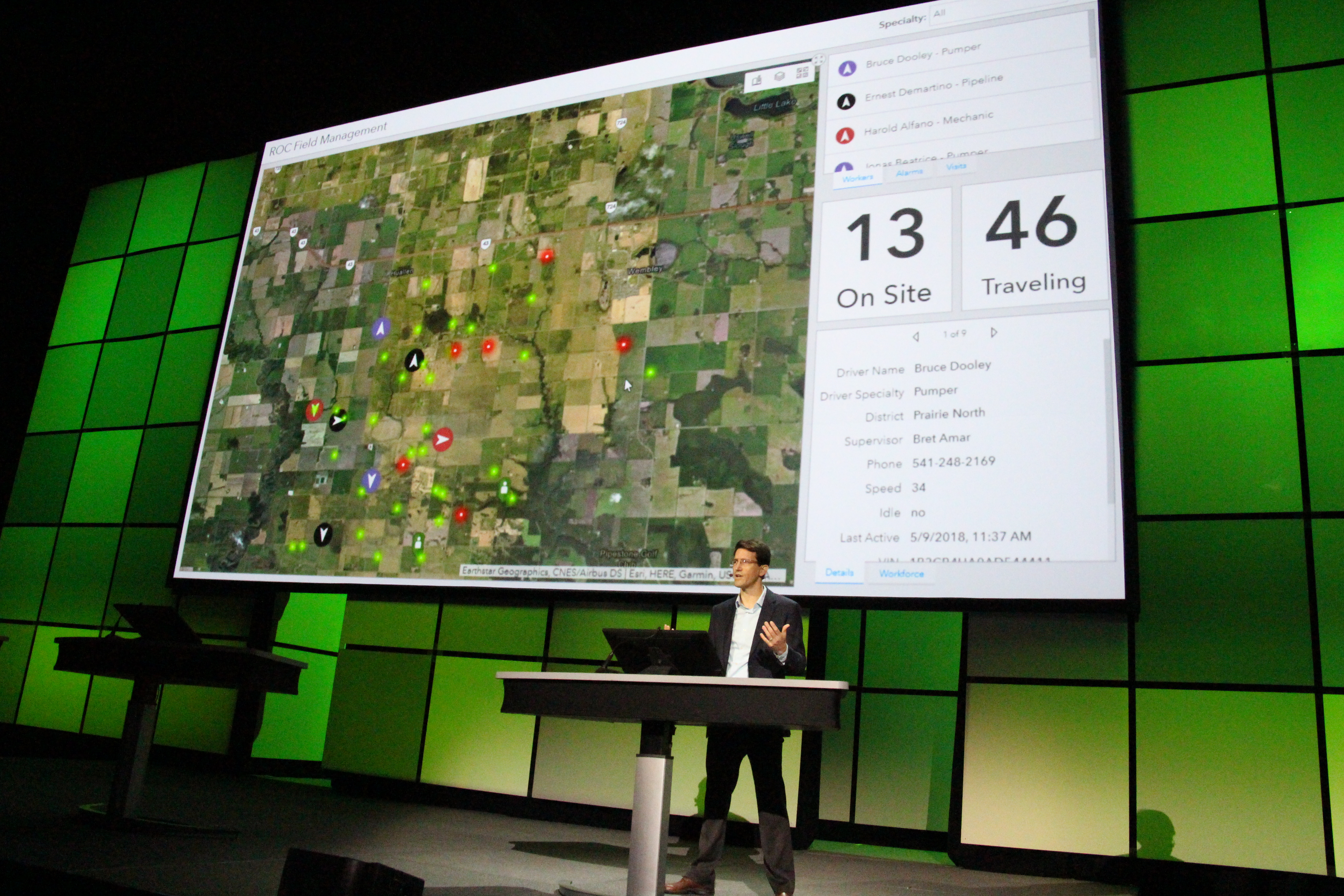
Esri demoed the latest technical capabilities added to its ArcGIS platform. For instance, ArcGIS Indoors is a new facility operations management tool, that optimizes workspace for better collaboration and asset inventory management. ArcGIS Monitor manages and monitors enterprise server deployments diagnoses, heals and improves performance. The Seneca GIS team demoed how it is using the ArcGIS Workflow Manager web tool to help manage and monitor the company’s development projects and respond quickly to hiccups that could cause delays.
HUBUB about the road ahead
 Some attendees were new to the conference while others had been coming for more than 20 years. They compared notes about GIS experts’ roles have changed in their companies due to the growing capabilities of GIS. The platform has become a self-service mapping system for staff throughout the enterprise and some traditionally ‘non-GIS departments’ are now building their own GIS apps. This freedom has opened opportunities for GIS experts to take on the roles of innovation champions and technology leaders.
GIS managers shared how they have been included in high-level planning meetings with company leaders and have become very much involved in high-level decision-making. They are a part of designing location strategies that derive value from the technologies. Attendees were encouraged to raise the scope of their vision to the enterprise scale, as they develop location strategies that improve the effectiveness of the workforce, provide business intelligence for decision making, and connect their companies with customers.
Representatives from oil, gas, and pipeline companies provided 40 user presentations ranging from subsurface analysis to satellite imagery interpretation. Many shared best practices showing how enterprise-level web technologies have changed their approaches and that they were saving their companies millions of dollars. In the next few weeks, these talks will be posted under preceding’s on the Petroleum GIS Conference page.
Esri and partners presented 18 technical sessions and attendees tried out solutions in the hand-on learning lab. In the GIS Solutions EXPO hall, 50 vendors provided insight into their products and services. The 14 sponsors who made this event successful helped keep registration costs down and provide meals and various social events, including the popular PUG evening social.


The Petroleum User Group - PUG
The Conference’s final session was the PUG Steering Committee meeting. Comprised entirely of petroleum GIS users, the committee helps direct the Esri development team by providing recommendations for product enhancements that meet the O&G and pipeline industries’ most pressing needs. PUG asked Esri to help standardize a set of common workflows that can be used across the industry. Users can participate in creating these opensource workflows by submitting their workflows via Linkedin @pugonline.
The committee also shared concerns about the decrease in qualified geospatial technology staff. Where have they gone and how can we get them back, now that the industry is an upswing? GIS experts are looking for new opportunities and students are considering the field. To build career information and raise the aspirations of those considering a GIS career in O&G, PUG is hosting a survey that will provide the community insight into compensation as it relates to education, roles, and responsibilities. Please do spend a few minutes to complete the confidential salary survey.
Esri announced that it has re-launched the GeoNet Petroleum page, which offers another way for customers, partners, distributors, staff and others in the GIS and geospatial professional community to connect, collaborate, and share ideas. This one-stop resource center is a place to discuss topics and collaborate; ask questions and get answers; read the latest blogs and follow the various social media channels, including the Twitter feed. Connect with GeoNet.
You must be a registered user to add a comment. If you've already registered, sign in. Otherwise, register and sign in.