- Home
- :
- All Communities
- :
- Industries
- :
- Water Utilities
- :
- Water Utilities Questions
- :
- Looking for a help to create Gravity Main layer da...
- Subscribe to RSS Feed
- Mark Topic as New
- Mark Topic as Read
- Float this Topic for Current User
- Bookmark
- Subscribe
- Mute
- Printer Friendly Page
Looking for a help to create Gravity Main layer data using existing Utilities (water/sewer) CAD Maps
- Mark as New
- Bookmark
- Subscribe
- Mute
- Subscribe to RSS Feed
- Permalink
I have many Manholes (points) data from a county Utilities CAD maps. I need to create Gravity Main lines using these Manhole points. The gravity main feature should include the attribute fields 'FromManhole' and 'ToManhole' which should be based on the direction of flow. I can also generate the Gravity main line from CAD maps but the problem is how do i get the mentioned attribute info without doing extensive manual entry. Is there any software or tool that automate this task or read the Flow direction 'arrow' (which is in CAD file) symbol???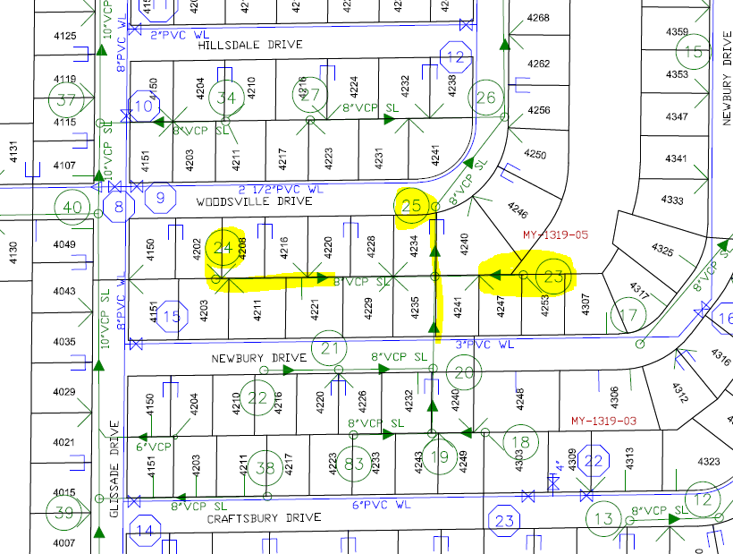 Thank you so much.
- Mark as New
- Bookmark
- Subscribe
- Mute
- Subscribe to RSS Feed
- Permalink
If you are using ArcMap, The Water Geometric Network Editing and Analysis template, and specifically the Attribute Assistant Add-In, can automatically calculate those attribute fields - Water Geometric Network Editing and Analysis | ArcGIS Solutions for Water
- Mark as New
- Bookmark
- Subscribe
- Mute
- Subscribe to RSS Feed
- Permalink
Thank you for the hint. I tried researching this and try to adjust the Dynamic Table this but still not sure how it will update the fields on my Gravity Main data. 
Here, 'MAP013_Manhole' is a separate MH point layer where 'Asset_Num' is the fields that contains MH numbers.
After this, I ran the manual rules for the selected features but nothing has changed. I am not sure I am doing it right or not because I just started to use this tool. Could you please tell me where I am wrong!! I appreciated your kind reply and any suggestion. Thank you so much.
- Mark as New
- Bookmark
- Subscribe
- Mute
- Subscribe to RSS Feed
- Permalink
Mandira,
Those methods only work with features participating in a geometric network.
I think you want Intersecting Feature instead. All methods - Attribute Assistant | ArcGIS Solutions
Also, per the FAQ, the display name of the DynamicValue table must be exactly DynamicValue -- not sure if your table name _testGM is causing you issues.
- Mark as New
- Bookmark
- Subscribe
- Mute
- Subscribe to RSS Feed
- Permalink
Mandira, I noticed the screen shot and subject heading also include reference to water. Just wanted to clarify that you were only looking at flow direction for the gravity sewer system? Respectfully, Martin
- Mark as New
- Bookmark
- Subscribe
- Mute
- Subscribe to RSS Feed
- Permalink
Hi Martin:
Yes, I am converting data from Utilities CAD maps to GIS data for all over the county and for almost all utilities (Water/Sewer) data. I also have manhole points and want to create Gravity lines based of on Manhole points and Flow Directions. I have two choices
1. Either I have to generate lines using manhole data or
2. Get the Gravity Main lines from CAD, use manhole points layer, and populate the attribute fields 'FromManhole' and 'ToManhole'
In both cases these two fields should be populated based on directions of flow; and the flow directions info could only be get from the CAD maps or digitized direction. If there is the better way to work on 1st method would be great but I do not know how..So I thought the 2nd method would be easy but could not exactly figure out how to get these fields populated easily. I have recently installed the Water Geometric Network Editing and Analysis tool but still not sure how to work with it.
If you have better or detail idea to share..I would appreciate it. Thank you so much.
- Mark as New
- Bookmark
- Subscribe
- Mute
- Subscribe to RSS Feed
- Permalink
Thank you so much to you all for your responses and hints. I followed your suggestions and my problem is solved. I appreciated you help!