- Home
- :
- All Communities
- :
- User Groups
- :
- Coordinate Reference Systems
- :
- Questions
- :
- Coordinate System
- Subscribe to RSS Feed
- Mark Topic as New
- Mark Topic as Read
- Float this Topic for Current User
- Bookmark
- Subscribe
- Mute
- Printer Friendly Page
Coordinate System
- Mark as New
- Bookmark
- Subscribe
- Mute
- Subscribe to RSS Feed
- Permalink
How do you use the “Project” tool to create a new layer in the same coordinate system as the other layers?
Thank you,
Nick Z
- Mark as New
- Bookmark
- Subscribe
- Mute
- Subscribe to RSS Feed
- Permalink
Project tool doesn't use for copy layers
you can copy layers using the following methods:
1. Right click on the layer on TOC and Export it.
2. Use Copy Features .tool.
3. use Feature Class To Feature Class tool.
- Mark as New
- Bookmark
- Subscribe
- Mute
- Subscribe to RSS Feed
- Permalink
Thank you. I will give that a try and let you know. Basically, I have three layers (census tract, census block and boundary) that are in different geographic coordinate systems and all of the layers must be in the same coordinate system in order use the Flood Information Tool in Hazus.
- Mark as New
- Bookmark
- Subscribe
- Mute
- Subscribe to RSS Feed
- Permalink
sorry, maybe i don't understand your question well
so
the answer for your question is :
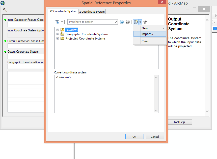
use Import while using Project tool and select the output coordinate system. and browse the other layer that you want to project to.
- Mark as New
- Bookmark
- Subscribe
- Mute
- Subscribe to RSS Feed
- Permalink
Am I trying to change the Projected Coordinate System or the Geographic Coordinate System?
Thank you,
Nick
- Mark as New
- Bookmark
- Subscribe
- Mute
- Subscribe to RSS Feed
- Permalink
Yes indeed. Thank you for the resources.
- Mark as New
- Bookmark
- Subscribe
- Mute
- Subscribe to RSS Feed
- Permalink
Thank you Abdullah Anter. I am unable to find the output coordinate system using the Import function in the Project Tool. But, I am able to search for it (WGS_1984_UTM_Zone_10N) in the Spatial Properties Box and select it. The problem is I can't find the census tract, census block and boundary layers that I want to project to WGS_1984_UTM_Zone_10N because they are coming from an SQL Server. I believe that means they are accessing online data types? I may be mistaken.