- Home
- :
- All Communities
- :
- Developers
- :
- ArcGIS REST APIs and Services
- :
- ArcGIS REST APIs & Services Ques.
- :
- interpolation using API REST
- Subscribe to RSS Feed
- Mark Topic as New
- Mark Topic as Read
- Float this Topic for Current User
- Bookmark
- Subscribe
- Mute
- Printer Friendly Page
- Mark as New
- Bookmark
- Subscribe
- Mute
- Subscribe to RSS Feed
- Permalink
Hello I would like to use the API REST to interpolate a set of points stored in an ArcGIS Online layer.
I'm using this URL:
http: //www.arcgis.com/sharing/rest/content/features/analyze/InterpolatePoints/submitJob?token=ValidToken&url=67421744b8b549b49b5fb45ff836d45f&field=aqi&f=json
With a valid Token and in the url parameter the id of my points layer. But I get this result: {"error":{"code":400,"message":"Must specify either sourceUrl, input file or text."}}
How should I specify the input parameter if I want to use my layer stored in ArcGIS Online?
Thanks!
Solved! Go to Solution.
Accepted Solutions
- Mark as New
- Bookmark
- Subscribe
- Mute
- Subscribe to RSS Feed
- Permalink
You're using the wrong endpoint. If you go through ArcGIS REST API: Spatial Analysis Service | ArcGIS for Developers you'll see references to for example http://<analysis url>/InterpolatePoints, <analysis url> is your GP Server endpoint. Typically with an ArcGIS Online account this is analysis.arcgis.com/arcgis/rest/services/tasks/GPServer. So to submit an interpolate points request you would use http://analysis.arcgis.com/arcgis/rest/services/tasks/GPServer/InterpolatePoints/submitJob
- Mark as New
- Bookmark
- Subscribe
- Mute
- Subscribe to RSS Feed
- Permalink
Thanks for your answer, I changed the endpoint and now I getting this error:
{"error":{"code":401,"message":"You do not have permissions to use this resource.","details":[]}}
My layer is public, and the token is valid, do you know what could be the problem?
- Mark as New
- Bookmark
- Subscribe
- Mute
- Subscribe to RSS Feed
- Permalink
The analysis services consume credits, so you would need an organizational account and be authorized by your admin to use these services...
- Mark as New
- Bookmark
- Subscribe
- Mute
- Subscribe to RSS Feed
- Permalink
I'm in an organizational account, I didn't know I should be authorized to use the service.
Thank you!
- Mark as New
- Bookmark
- Subscribe
- Mute
- Subscribe to RSS Feed
- Permalink
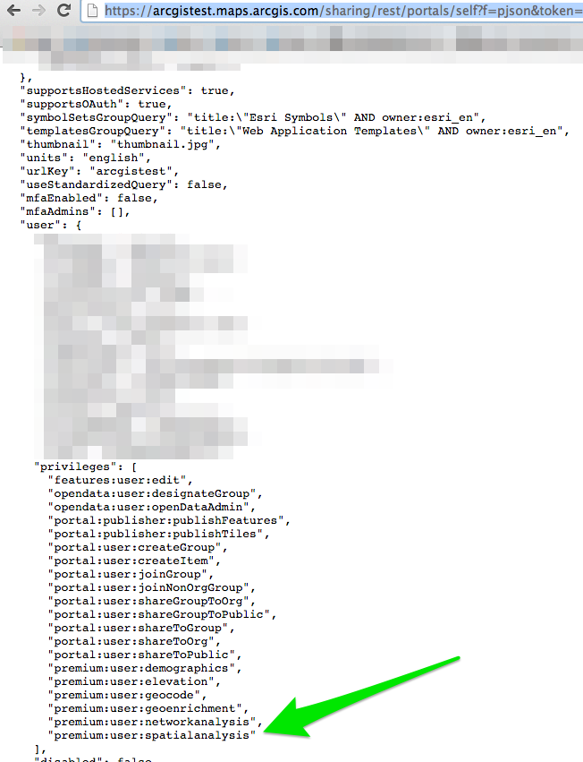
You can check by going to https://arcgistest.maps.arcgis.com/sharing/rest/portals/self?f=pjson&token=<token> and verify you have the "premium:user:spatialanalysis" privilege:

(of course use your own org. url instead of arcgistest.maps.arcgis.com)
- Mark as New
- Bookmark
- Subscribe
- Mute
- Subscribe to RSS Feed
- Permalink
Yes, I'm missing it.
Thanks!