- Home
- :
- All Communities
- :
- User Groups
- :
- Web AppBuilder Custom Widgets
- :
- Questions
- :
- LocalLayerWidget Version 2.5 and AccessifizrWidget...
- Subscribe to RSS Feed
- Mark Topic as New
- Mark Topic as Read
- Float this Topic for Current User
- Bookmark
- Subscribe
- Mute
- Printer Friendly Page
LocalLayerWidget Version 2.5 and AccessifizrWidget Layer - 09/28/2017
- Mark as New
- Bookmark
- Subscribe
- Mute
- Subscribe to RSS Feed
- Permalink
I've been having a blast playing around with the new Web AppBuilder, and have taken a few cracks at putting together some custom Widgets that I'd like to share with the community. I hope these can assist in everyone's future Mappmaking endeavours!
LocalLayerWidget
LocalLayerWidget v 2.5
September 28 2017 : LocalLayerWidget v2.5 released: This major release includes the following enhancements for the widget. Thanks to everyone who's donated!:
Release LocalLayerWidget 2.5 · cmndrbensisko/LocalLayer · GitHub
- Support for 2.5 Release of ArcGIS Web App Builder
- Support for Custom Layers via Transformers
- Demos and sample apps
- Prototype 3D Widget
- Dynamic GUI changes at runtime and css insertion via odds.json/odds.css
- And more!
November 14, 2016: LocalLayerWidget v2.2 released: This major release includes the following enhancements for the widget:
Release LocalLayer v2.2 · cmndrbensisko/LocalLayer · GitHub
- Related Table Viewing and Editing
- ImageService Viewing and Popups
- WMS Service Viewing and Popups
- Ability to integrate with the IncidentAnalysis widget
- Hide Layer In Legend capability added
- Dynamic mode added, allowing for URL-fed configuration files
- And more!
May 18, 2016: LocalLayerWidget v.2.0 released: This substantial change for Web App Builder v.2.0. removes the need to edit any core files in the Web App Builder, unlike previous versions. A slight change will still be necessary for the AttributeTable widget to work properly with LocalLayerWidget layers.
- https://github.com/cmndrbensisko/LocalLayer/releases/tag/v2.0
- Enhancements:
- Added autorefresh capability for dynamic layers, and sub-minute decimal values can be specified for time.
- Added support for non-consecutive sublayer numbering to support 10.3.1 mapservices
- Editor Tracking via an organizational Active Directory instead of ArcGIS Online User now supported
- Bug Fixes:
- View Attachments now works for Dynamic Layers
- Addition of GeoJson layers fixed
- Fix to MapService sublayer visibility when no sublayers are selected to display by default.
Mar 29, 2016: LocalLayerWidget v.1.3.1 released; Contains bugfixes to v.1.3. related to custom rendering for Feature Layers and toggling sublayer visibility in the LayerList widget.
Mar 22, 2016: LocalLayerWidget v.1.3 is now available! (Note the version naming change; Version 1.3 refers to its compatibility with v1.3 of the WAB - This is indeed the latest version of the widget as of March 22, 2016). Be sure to read the github page to see what tweaks need to be made to ensure that everything continues running smoothly in version 1.3 of the Web AppBuilder.
- Includes support for GeoJSON and WebTileLayers
- Custom Symbology and Labelling Options for Feature Layers
- Currently requires the use of playground to generate custom json layer and label styling for Feature Layers. For more information, please follow the instructions on the Github page.
Feb 10, 2015: LocalLayerWidget v.1.5 is now available! This release contains full support for adding Tiled layers to your application directly from ArcGIS Server, in addition to the Basemap, Dynamic, and Feature layers available before. Feel free to grab the widget from our Release page located at https://github.com/cmndrbensisko/LocalLayer/releases.
Feb 2, 2015: LocalLayerWidget v.1.2 is now available! This release provides a great GUI developed by Robert Scheitlin to more easily add Feature, Dynamic, and Basemap layers to your ArcGIS Web AppBuilder Applications. Take it for a spin, and please keep us informed of any bugs or desired enhancements through our Github Issue Tracker located at https://github.com/cmndrbensisko/LocalLayerWidget/issues.
Jan 12, 2015: Note that LocalLayerWidget v.1.1 is now available, which provides Click-To-Identify support and the option to add Feature and Basemap layers in addition to Dynamic layers.
The LocalLayer Widget is intended to allow the direct addition of MapServices to an ArcGIS Web AppBuilder application, without needing to wrap the desired services in an ArcGIS Online/Portal Web Map.
https://github.com/cmndrbensisko/LocalLayerWidget
Basically, your basemap will still need to come from Portal/AGOL, but otherwise you just provide direct URLs to your own MapServices in the widget's configuration settings. The MapServices should load and display as usual in the map, and cooperate with the Legend, LayerList, and Attribute Table widgets. Click-To-Identify functionality won't work currently, though, because the current WAB implementation relies on Portal for all the popup info. As stated in the January 12th 2015 release, popups are fully customizable. Note that it's not an in-panel widget, so you'll need to follow a few extra steps in the project's Readme file.
AccessifizrWidget
Let's make Mapps accessible for everyone! With an eye on WCAG compliance, the Accessifizr Widget is designed to help make web applications keyboard navigable without having to modify core application code and UI.
https://github.com/cmndrbensisko/AccessifizrWidget
Information about how to configure this widget is available in the core Accessifizr.js library project available here, but the gist is that you create a JSON-based 'roadmap' detailing the keyboard navigation of your web application, and how it should change in response to users entering modal menus, hitting the escape button, etc. For applying descriptive alternate text to page elements, the widget leverages dojo's built-in internationalization support to specify multilingual alternate text strings. The end result is a web app that, hopefully, is a bit easier to use for people with mobility or visual challenges.
- Mark as New
- Bookmark
- Subscribe
- Mute
- Subscribe to RSS Feed
- Permalink
I'm glad you find it useful, Barnaby! A future release might better show the nesting of grouplayers as well.
I've put up a hotfix for the single layer bug you found, and updated the manifest file. Version 1.2.2 is now available.
- Mark as New
- Bookmark
- Subscribe
- Mute
- Subscribe to RSS Feed
- Permalink
Hi Adam,
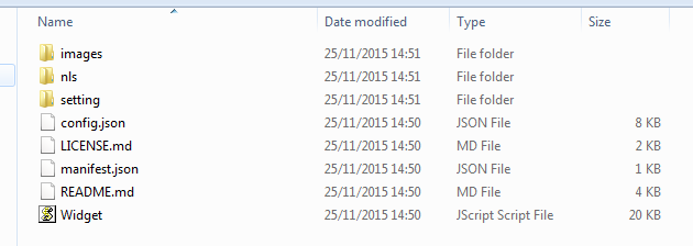
For some reason the locallayer widget will not work for me. It won't even open, when i opened the locallayer folder i noticed there was no HTML file inside it, should there be one for it to work?
- Mark as New
- Bookmark
- Subscribe
- Mute
- Subscribe to RSS Feed
- Permalink
Finbar,
No there is not suppose to be a html file with this widget. The widget does not have a UI only a settings UI. There are lots of people using this widget myself included, so it is not a issue with the widget. Did you follow the directions on the GitHub page for adding it to WAB?
- Mark as New
- Bookmark
- Subscribe
- Mute
- Subscribe to RSS Feed
- Permalink
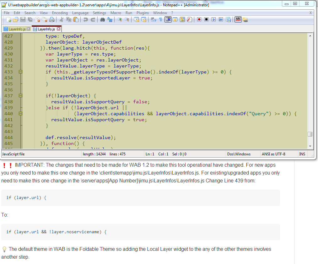
Where it asks me to make the change on line 439, the code is different in the LayerInfo.js.
Instead of - (layer.url) { - It displays - }else if (!layerObject.url || - Any ideas?
- Mark as New
- Bookmark
- Subscribe
- Mute
- Subscribe to RSS Feed
- Permalink
Finbar,
What version of WAB are you using?
- Mark as New
- Bookmark
- Subscribe
- Mute
- Subscribe to RSS Feed
- Permalink
Finbar,
You are looking in the LayerInfo.js and not the LayerInfos.js (notice the plural).
- Mark as New
- Bookmark
- Subscribe
- Mute
- Subscribe to RSS Feed
- Permalink
Robert,
Cheers for that, I may get the eye sight checked.
- Mark as New
- Bookmark
- Subscribe
- Mute
- Subscribe to RSS Feed
- Permalink
Hi Adam Drackley
This LocalLayerWidget is a really nice thing and I must say I find it very useful.
Have you ever thought of adding WMS support to this widget?
Cheers
R.
- Mark as New
- Bookmark
- Subscribe
- Mute
- Subscribe to RSS Feed
- Permalink
I'm glad you're finding the tool useful, Ramon. We've been adding functionality on an as-needed basis, but I can certainly see the benefit of being able to use WMS/WFS/WMTS layers in the application.
I'm wondering how well these services would cooperate with the other Widgets like the Legend and Attribute Table. I'll add it to the list of enhancements to investigate for the next release.