- Home
- :
- All Communities
- :
- User Groups
- :
- Web AppBuilder Custom Widgets
- :
- Documents
- :
- Google Street View Widget 2.1 - 08/29/16
- Subscribe to RSS Feed
- Mark as New
- Mark as Read
- Bookmark
- Subscribe
- Printer Friendly Page
Google Street View Widget 2.1 - 08/29/16
Google Street View Widget 2.1 - 08/29/16
All after much back and forth with different people and what now seems to be legitimate email traffic with the Google Maps API Team. It is now apparent that this widget does NOT conform to the Google Maps API Terms of Service. Due to this fact, this widget download will be removed and the live preview site will be un-accessible. It is my recommendation that all users of this widget immediately remove the widget from their WAB site and discontinue use of this widget. The only way it seems currently to be compliant with the TOS is to not have a (non-Google) map visible at all in the app which is of no use at all to us esri users. I find it hard to understand how the Worlds leader in GIS technology and Google can not come to terms on the use of StreetView panoramas with esri basemaps, but it is what it is. So after years of this widget being used by hundreds of users around the world we must say good-bye.
Here is another widget for the Web App Builder.
Web AppBuilder for ArcGIS | Help - Google Street View widget
List of the latest enhancements and changes:
- Updated for WAB 2.1
List of older enhancements and changes:
- Widget no longer open the street view html window automatically on open.
- Prevent popup check from firing multiple times.
- Removed sensor portion of the StreetView code as Google has depreciated it.
- Minor configuration UI changes.
- Widget code updated to work with all the new themes and their style colors.
- Fixed issue with maps whose spatial reference was not 4326 or 102100
Features:
- This widget conforms to the Google Terms of Use (TOS) agreement
- Widget allows configuration of Google Street View Panorama Options
- Widget provides drag and drop support
- Widget provides graphical feedback on the map when changes are made to the Street View Panorama window
- This widget displays the Google Street View Panorama in a popup browser window as to not violate the Google TOS agreement
Sorry my web server must have gone down.
robert when we download this widget and we are trying to incorporate this tool in our map where do we install and save the files?
Hi Robert, are you sure that this widget is conformed to the ToS ?
Google sends me email that they have replied me as follows "10.4.e is the relevant ToS--"No use of Content with a non-Google map. You must not use the Content in a Maps API Implementation that contains a non-Google map." in other words, if you show a map it must be a Google Map."
Domenico,
If you look at 10.4.d you will see:
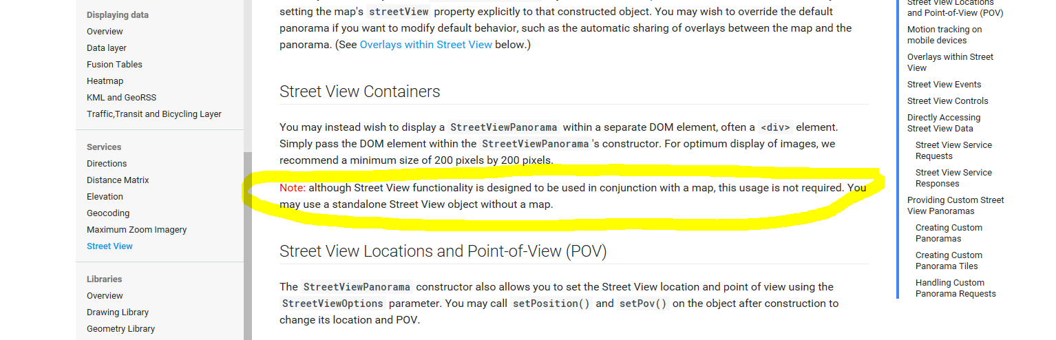
d. No use of Content without a Google map. Unless the Maps APIs Documentation expressly permits you to do so, you will not use the Content in a Maps API Implementation without a corresponding Google map. For example, you may display Street View imagery without a corresponding Google map because the Maps APIs Documentation expressly permits this use.
e. No use of Content with a non-Google map. You must not use the Content in a Maps API Implementation that contains a non-Google map.
In fact it 's how I have answered Google Map Team
but if see the detail in help api google seems that you can use it without a map but if you use a map it must be google map. (10.4e)
https://developers.google.com/maps/documentation/javascript/streetview
Geo User,
And who are you? And how do you explain 10.4.d
d. No use of Content without a Google map. Unless the Maps APIs Documentation expressly permits you to do so, you will not use the Content in a Maps API Implementation without a corresponding Google map. For example, you may display Street View imagery without a corresponding Google map because the Maps APIs Documentationexpressly permits this use.
Hi,
That's not the use that you are doing. You are using the content without a non-google maps and. It's covered by the item: 10.4.e -- "No use of Content with a non-Google map. You must not use the Content in a Maps API Implementation that contains a non-Google map."
in other words, if someone shows a map it must be a Google Map and there is no exception for it.
That's not the use that you are doing.
That is Exactly what I am doing I am using a streetview image without a corresponding Google map.
What you are saying is in direct contradiction to 10.4.d.
sorry, It's not that. You need to use the topic 10.4.e......10.4.d is completely related with 10.4.e...in other words, if you are using google content it should be on google maps base maps. It's very straight forward.
ciava.at also has replied the same vision and it seems that he has already talked with Google Maps team.
Geo User,
Thanks for your opinion, but the only thing that is clear is that there is a specific exception for StreetView images that is covered by 10.4.d where they specifically do not require the use of a Google map. 10.4.e then goes on to cover other aspects of the API usage not specific to StreetView images.
you are correct on it. It's allowed to use Street View without a map (10.4.d) but if you use a map it should be a Google Maps (10.4.e). When I said that both are related is regarding that.
So again, its clear that is not allowed to use Street View content with a non-google maps. This is a great plugin but it's not compliant with Google's ToS.
Sorry but unless you actually work for Google it's really just conjecture whether it's against the ToS or not. And lets be realistic...Google is very good at shutting down things that they find are against their ToS, and since this one is still alive and well it's probably OK to use. Great work Robert!! Love this widget!
I already have talked with Google Maps team and they confirm me that the ToS means that a standard SV functionality can be used without a map but it can't be used in conjunction with a not Google map
" ... without a corresponding Google Map ..." means standalone SV (see my highlight yellow from help Maps API)
Domenico,
That email correspondence you had with an entity that claimed to be The Google Maps Team would never provide any validation of being an actual Google contact. It is easy to spoof a email address like [email protected] (shoot even I can do that). I emailed back an forth with them a couple of times and several of the emails were suspect as to be an actual representative of Google. In one email we asked for a couple of things to determine the legitimacy of the emails:
Can you please provide me with:
- Unique incident # (the on in the subject line is one associated with other entities).
- A phone number to call concerning this issue
3. A point of contact name concerning this issue.
We asked for number one because their email to us was based off of emails to you and had an incident number that was specific to their correspondence with you.
number two and there were obliviously a means to validate them as a true Google representative. The next email we received answered none of these questions. So I sent them an email stating if they would not provide the requested info that we would cease communication. Then I received this response:
Please find the requested information below:
- Unique incident # (the on in the subject line is one associated with other entities).
The domain The domain where the violation is found : https://community.esri.com/docs/DOC-2991
- A phone number to call concerning this issue.
We are not supposed to give any contact details or telephonic conversations regarding any issues.
- A point of contact name concerning this issue.
We only have conversations through emails. For more information on the concerned issue please reply to this email thread.
As you can see number 1 was not at all what was requested
Number 2 and 3 well that just made me laugh, so we ceased any further email communication.
I searched the Google Maps API website attempting to find some way to contact them and could find nothing.
hi all
someone asked me offline what I thought about this issue so here are my 2 cents:
1) I think the Google docs and TOS are really confusing on this issue
2) that said, I'm quite sure Domenico and Geo User's interpretations are the correct one. If you have no map, you can use Streetview. If there is a map, it must be a Google Map
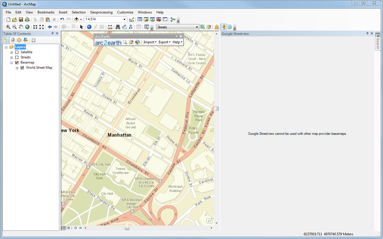
3) When we were adding Streetview support to Arc2Earth, various Google PMs asked specifically that we enforce this rule in ArcMap. The use case they didn't want to happen was having a MS Bing basemap with Streetview used over the top of it. We asked about carving out the default ESRI basemaps and that was shot down. A Google maps must be displayed or no Streetview at all. So we ended up having to write code to detect non-Google basemaps and then activate/deactivate the Streetview tools (see attached)
4) This was a year ago so this may have changed but I doubt it, if anything they are more strict in enforcing the TOS
just my 2 cents, if anyone wants to talk to a Google rep, I can try to put you in touch directly (as Robert mentioned, they are not the easiest group to get in touch with)
Brain,
I would like to talk more about this, can you follow me on GeoNet so I can Private Message you?
Robert,
I am sad that your street view widget is not supported by google.
Have you seen this:
Rickey,
I have but it a there is not much comparison when it comes to total coverage.
Robert Scheitlin, GISP i am currently using google basemap ( web tile layer with localLayer widget) in my app is it illegal too?
Haider,
Yes that is not allowed as the TOS explicitly states no use of the tiles layers without using the Google Maps API.
Even with a Google API key streetview can not be used? It is a shame if streetview is gone completely and forever from Web App Builder?
George,
The widget is not compliant and thus the API Key does not matter.
Thi is quite sad but the ToS must be respected.....I was just taking a look at this widget for some of my users who required them, however now have to break the news to them.
Thanks rscheitlin
What about my customized version, does it comply? It does display a Google map when you drag pegman. You can see what I mean here..
Ian,
I tried that route with them as well and they said if you show a map other then Google map at when using StreetView images then you are in violation. I thought th same thing that I could switch to a Google base map when the peg man is dropped as you are doing but they said that would still be in violation because there is a non google map displayed in conjunction with the StreetView image as some point.
That's awesome Ian! It kind of threw me off for a sec when it flashed over, but it's really cool being able to view where coverage is available.
David,
I agree that it is a great addition that was going to add to my widget as well with Ians code. But it does not make a difference when Google will come along and shut you down due to TOS violations.
Any chance of reviving this with Bing's street view? They seem to be a bit more ESRI friendly.
Bummer, okay. Sheesh, we are actually trying to use Google's service and they try to stop us. I understand, they are very very specific with what they allow. I ran into this once before with a different tool I developed to grab their imagery and automatically georeference it within ArcMap. I thought the web based Street View widget would be okay..guess again.
This is really lame on Google's part. Shame on them. I'm sorry to see all of Robert's awesome work on this widget go to waste. I have a super basic widget that links out to Google Maps, Bing Maps, or Pictometry based on the center and zoom level of my map, I guess it will have to do. But this kind of sours the experience of using Google's product for me. Bing's Street Side actually has better coverage in my county than Street View does anyway.
Hi Robert ,
Is there a way to re config this widget to replicate that used by Interactive Map - County of Simcoe (GIS) , where they used a panel for the google streetview and an underlining google map so as to not breach the T&C. See image below:
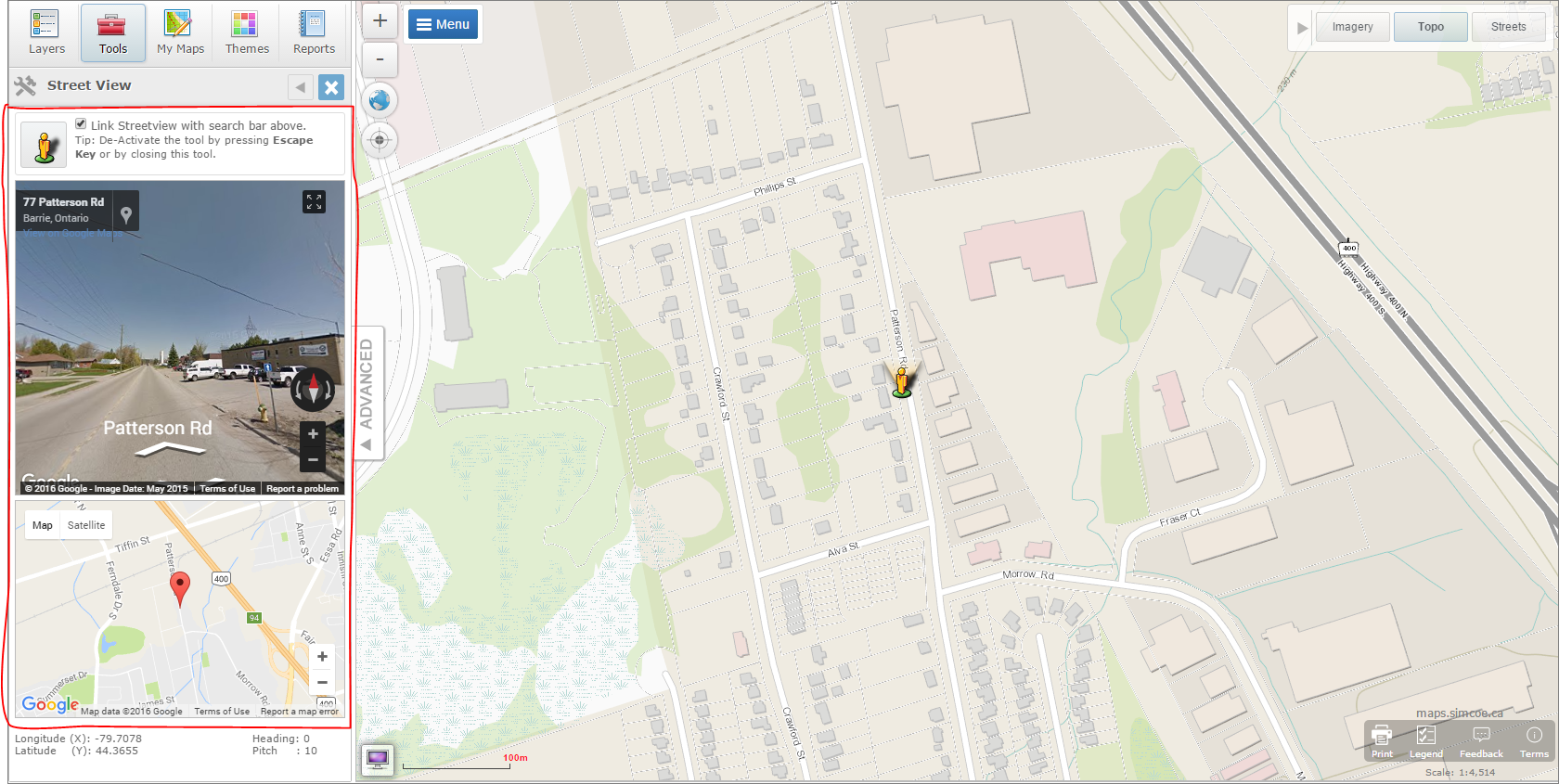
Just a suggestion.....
Cheers
Baba
Baba,
Based on my conversation with Google Maps team I don't believe that it satisfies their TOS either.
Ooh seen,
which means "they" might be breaching the TOS too?
Just a suggestion anyway, thanks for the reply
We (The County of Simcoe) saw this posting on GeoNET when it first came out and have re-worked the way we link to Google Street View. It's still a work in progress but you can see the implementation at the below link. I would have to guess that Google changed the terms because we read them top to bottom about a year ago to ensure we were in compliance. 10.4 - e seems to be the kicker ..
- No use of Content with a non-Google map. You must not use the Content in a Maps API Implementation that contains a non-Google map.
Our Implementation (External Services Widget)
Interactive Map - County of Simcoe (GIS)
Thanks,
Drew
Andrew,
Great job with your site as always. Your implementation of the external site is the only way I see (currently) to satisfy the Google TOS. I will still be working with Google Maps Team to see if there is any other alternative though. Thanks for showing everyone a site that shows proper usage of streetview imagery.
My Streetview still works great in Web App Builder 2.1 - GitHub - kevinsagis/Streetview: Streetview Widget for ESRI WebApp Builder 1.1
Demo site - ArcGIS Web Application
UPDATE::: My widget apparently does not conform. Mine passes the lat/long into the URL and this is also verboten per Google ToS.
Kevin,
Unfortunately it does not. It is not the interaction between the two that violates the TOS, it is the use of a non-Google map to bring up the streetview window that violates the TOS. If you have any map other than a Google map then you can not click on that map to bring up a StreetView window.
Thank you for the advice Robert. I will take down my repository as you have done and update my post. 
FYI to all, I will then at some point update my Widget blog post to your thread-style format and update widgets to WAB 2.1 as needed.
It's ironic because Google shows ads in Streetview, thus generating revenue.
Therefore, I will research whether we can construct a Bing Streetview widget. It sure appears they're more open. It may be the way to go:
MICROSOFT® BING™ MAPS PLATFORM API's TERMS OF USE
StreetSide: Dynamic Street-Level Imagery via Bing Maps
Interestingly enough, I found this page (apparently compliant since Google map is shown first and originates the location) ---- Dual Maps: Google Maps, Street View and Bing Maps in an embeddable control - www.mapchannels.com
Hello Robert,
Are you able to point me to the terms that says we can not use a non google maps to bring up Street View?
I don't see how google can say that because its just hyperlinking to their page - The entire premise of the world wide web.
Drew
Kevin,
I believe the way dual maps conforms is the fact that a Google map is used in the map and an additional non-google map is also used. The main thing is that a Google map is shown from the beginning.
Andrew,
What the Google Maps team explained to be is that use of a non-Google maps to interact with StreetView is covered by TOS 10.4.e
It is a shame. And I think there needs to be someone from ESRI to go and work with Google to try to find acceptable solutions to allow Google maps to be used in ArcGIS environment
Hi Robert,
The Terms of Service you're referencing are for API use - is constructing a URL and launching in a new window (as per Simcoe County map) an API implementation? I ask in earnest because I know you have a deeper understanding of the technical side of the API.
Thanks,
Rob
Rob,
The issue is interacting with a none Google map to bring up the streetview image is a violation of the TOS. If you click on a map to define the location that you want a streetview image for then it has to be a google map. I seems that you can click on a non-google map and bring up a Google API map and then from that map bring up a streetview image.
From what I've read, it is a violation of the API specific TOS, not the general TOS. I'm concerned about instanced where API is not used, as per Simcoe County's latest map.
Rob,
You are using the Google Maps API to gain access to a StreetView panorama. So you Must conform to the Google Maps API TOS.
Using tiles and or images directly without using the API is yet another TOS violation.