Turn on suggestions
Auto-suggest helps you quickly narrow down your search results by suggesting possible matches as you type.
Cancel
- Home
- :
- All Communities
- :
- Industries
- :
- Water Resources
- :
- Water Resources Questions
- :
- Solving Arc Hydro Problems by deleting TMP Files
Options
- Subscribe to RSS Feed
- Mark Topic as New
- Mark Topic as Read
- Float this Topic for Current User
- Bookmark
- Subscribe
- Mute
- Printer Friendly Page
Solving Arc Hydro Problems by deleting TMP Files
Subscribe
10414
8
04-27-2011 01:01 PM
04-27-2011
01:01 PM
- Mark as New
- Bookmark
- Subscribe
- Mute
- Subscribe to RSS Feed
- Permalink
I've seen several threads about Arc Hydro not working as expected. On a few of them I've responded the same way.
I'm in the middle of an Arc Hydro project and I am finding functions not working as expected just like a I see on a lot of these posts. My solution is as follows (it works almost every time):
Arc Hydro may be trying to create temp file that already exists.
In my Arc Hydro training at ESRI I was told that, when things start going "funny":
When this does not work. I close Arc Desktop and use Arc Catalog to delete shape files and rasters that I'm needing to create. I do this to ensure that there are no write protection errors causing problems.
I'm using Arc Hydro in Arc Desktop 10 with Windows 7.
Cheers.
(P.S. - ESRI, if you're listening, please fund those guys working on Arc Hydro so they can build in some safeguards against these kinds of problems! We've got better things to do than rant at our computers over these things! Thank you!)
I'm in the middle of an Arc Hydro project and I am finding functions not working as expected just like a I see on a lot of these posts. My solution is as follows (it works almost every time):
Arc Hydro may be trying to create temp file that already exists.
In my Arc Hydro training at ESRI I was told that, when things start going "funny":
- close ArcMap, go to your temp directory - In Windows 7, mine is at C:\Users\mboucher\AppData\Local\Temp
- delete everything you can.
- open the folder, sorting by date (new to old), and starting ArcMap.
- If this is the right directory, you will see temp files being created.
When this does not work. I close Arc Desktop and use Arc Catalog to delete shape files and rasters that I'm needing to create. I do this to ensure that there are no write protection errors causing problems.
I'm using Arc Hydro in Arc Desktop 10 with Windows 7.
Cheers.
(P.S. - ESRI, if you're listening, please fund those guys working on Arc Hydro so they can build in some safeguards against these kinds of problems! We've got better things to do than rant at our computers over these things! Thank you!)
8 Replies
12-01-2011
12:02 PM
- Mark as New
- Bookmark
- Subscribe
- Mute
- Subscribe to RSS Feed
- Permalink
I just found the function in Arc Hydro (ArcGIS v10) for clearing the temp files. It is under ApUtilities>Additional Utilities>Clean User's Temp Folder.
I think the only issue with using this is if you have a function that you recently ran that "might" be using a file in the temp folder, you might have to redo something.
I think the only issue with using this is if you have a function that you recently ran that "might" be using a file in the temp folder, you might have to redo something.
10-02-2013
06:28 PM
- Mark as New
- Bookmark
- Subscribe
- Mute
- Subscribe to RSS Feed
- Permalink
In my case appears a message that says:
Failed to create intermediate ESRI XML file Oject reference not set to an instance of an object
If anybody can helpme please...
Failed to create intermediate ESRI XML file Oject reference not set to an instance of an object
If anybody can helpme please...
10-03-2013
08:23 AM
- Mark as New
- Bookmark
- Subscribe
- Mute
- Subscribe to RSS Feed
- Permalink
I've collected an posted several Arc Hydro problem solvers on a thread. See link below my signature.
10-09-2013
10:38 AM
- Mark as New
- Bookmark
- Subscribe
- Mute
- Subscribe to RSS Feed
- Permalink
MBoucher, you are an angel for posting all the helpful tips here! I have followed your Problem Solving List and done everything you suggest, many times over. I have started more fresh new MXDs with new folder sets than I can count. This is my third day working on this project and I still cannot get Geo-HMS terrain preprocessing to work and I don't know what else to do. It will not Build Walls or, if I skip building walls and just go through the rest of the process, it will not delineate the Catchment Grid. Both are grid building errors, I believe. This the error I get when trying to Build Walls:
[INDENT]System.Runtime.InteropServices.COMException (0x80041098): ERROR 010236: Error in building VAT.
ERROR 010067: Error in executing grid expression.
at ESRI.ArcGIS.GeoAnalyst.RasterConversionOpClass.ToRasterDataset(IGeoDataset dataset, String rasterFormat, IWorkspace pWorkspace, String name)
at ESRI.APWR.ApHydro.ArcHydroOp.BuildWalls(ApLayers apLayers, Double innerWallHeight, Double wallBuffer, Double breachLineBuffer, ITrackCancel& trackcancel, IGPMessages& messages, String& exMessage)
Failed to execute (BuildWalls).
Failed at Wed Oct 09 12:25:17 2013 (Elapsed Time: 1.00 seconds)[/INDENT]
What do you do when it just won't work? Give up and just do everything by hand? I am out of ideas. Any help will be much appreciated.
Thanks,
Lisa
10-10-2013
10:12 AM
- Mark as New
- Bookmark
- Subscribe
- Mute
- Subscribe to RSS Feed
- Permalink
What do you do when it just won't work? Give up and just do everything by hand? I am out of ideas. Any help will be much appreciated.
Thanks,
Lisa
Well, here's what I did after posting the message. I kept trying and it occurred to me to try recreating the shapefiles I was using to define the basin boundaries and flow paths. And VOILA! IT WORKED!!
So, one more thing to try when you are having problems with terrain processing.
Lisa
10-10-2013
01:40 PM
- Mark as New
- Bookmark
- Subscribe
- Mute
- Subscribe to RSS Feed
- Permalink
... the shapefiles I was using to define the basin boundaries and flow paths. ... Lisa
Lisa,
What kind of shape files are you using to define the basin boundaries and flow paths?
I always start with rawdem (raster) and agreestream (polyline) file. I only use the innerwalls, and outerwalls if needed. Are you using another function that creates watersheds based on polygons? There appears to be one (Batch watershed delineation for polygons), but I've never used it and also I believe it is used after all the Terrain Preprocessing.
10-14-2013
08:40 AM
- Mark as New
- Bookmark
- Subscribe
- Mute
- Subscribe to RSS Feed
- Permalink
Lisa,
What kind of shape files are you using to define the basin boundaries and flow paths?
Originally I had polygons for both the inner and outer walls, but then I revised the inner walls to use lines. And the flow paths are lines. I am using the inner walls to define roadways in the basin. If I don't, the catchments are defined incorrectly (crossing the roadways where they shouldn't).
thanks,
Lisa
09-29-2014
10:32 PM
- Mark as New
- Bookmark
- Subscribe
- Mute
- Subscribe to RSS Feed
- Permalink
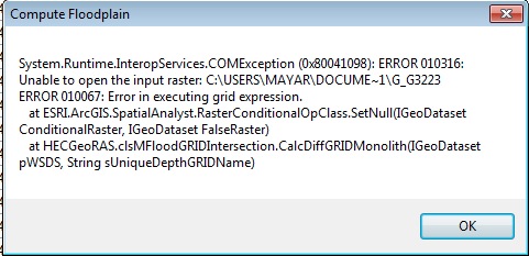
Dear Sir;
I did the cleanup of Temp folder and also transferred all folders to C drive , but still i have this error , could you please help me in this regard.
with regards
while delineate the floodplain i face this error, before that all process are done normal.