- Home
- :
- All Communities
- :
- Industries
- :
- Water Resources
- :
- Water Resources Questions
- :
- Re: ArcHydro Problem Solvers
- Subscribe to RSS Feed
- Mark Topic as New
- Mark Topic as Read
- Float this Topic for Current User
- Bookmark
- Subscribe
- Mute
- Printer Friendly Page
- Mark as New
- Bookmark
- Subscribe
- Mute
- Subscribe to RSS Feed
- Permalink
- Make sure the Geoprocessing extents include the whole project: Go to the Geoprocessing menu>Environments...>Processing Extent. Under Processing Extent choose a layer that you know covers the full extent of the waters you are processing and click OK. This should ensure that the processing extent is large enough to do what you want.
- Delete everything you can in your temp folder: Mine is C:\Users\mboucher\AppData\Local\Temp. Get out of ArcMap first to clear temp files related to your project. You can do this without getting out of ArcMap through the ArcHydro Toolbar under ApUtilities>Additional Utilities>Clean User's Temp Folder.
- Make sure your Target Locations are correct: Under ApUtilities>Set Target Locations, make sure the HydroConfig and they GeoHMSConfig Targets make sense. The raster data should go to the project folder vector data to a geodatabase. The raster data will go to a folder in the project folder with the dataframe name and the vector data to a feature data set with the dataframe name. Through the ArcHydro Toolbar under there is a function to reset the target locations: ApUtilities>Additional Utilities>Reset Target Locations. I've not tested this to see if it corrects everything.
- When working on a complicated model, don't use the model mxd for your presentation map. It just adds baggage to an already "heavy" mxd.
Solved! Go to Solution.
- Mark as New
- Bookmark
- Subscribe
- Mute
- Subscribe to RSS Feed
- Permalink
Annina,
Thanks for the ego boost. I am experienced through the "beating the head against the wall" ArcHydro methods gauntlet, so I guess that makes me an "expert". I am not a Python pro at all. I have gotten accustom to deciphering the ESRI error messages. If you can send the text or a screen shot of the error message, I'll see if that can point to a potential problem.
Are you processing the project on your local machine or over a network? That can make a difference, in my experience.
Best, Mark
- Mark as New
- Bookmark
- Subscribe
- Mute
- Subscribe to RSS Feed
- Permalink
Mark,
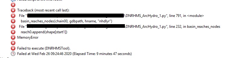
Here is a screenshot of the errors we get; thanks for taking a look.
The processing is done on a local machine; however, the NHD dataset is located on a network server. The weird part (well, not too weird, as I know Arc) is that the script has worked, even with the network dataset. I have a feeling there's something in the script that's causing the issue (but crossing my fingers you have an easier solution).
Thanks,
Annina
- Mark as New
- Bookmark
- Subscribe
- Mute
- Subscribe to RSS Feed
- Permalink
Annina,
I can't tell from those error messages what might be going on. The "error message" I'm thinking of is the one that appears while processing. An example is that provided in the image by Anne-Marie Dubois in her post on Aug 8, 2019 7:22 AM. If you can screen shot the run time error messages it might reveal something.
I did a Google search on "arcpy memory error" a few of the results could help your Python programmer. (I suspect done this type of search already):
- A result in GeoNet: memory error with python
- A result in ERSI support: Error: ERROR 000426: Out Of Memory
- A result in stackexchange: arcpy - Python MemoryError when running ArcGIS Python Toolbox tool - Geographic Information Systems ...
Hope this helps. I look forward to seeing the solution. I want to get my Python black belt doing Arc Hydro for me soon so your experience will be goo to follow.
Best,
Mark
- Mark as New
- Bookmark
- Subscribe
- Mute
- Subscribe to RSS Feed
- Permalink
Mark,
Doesn't seem to be a run time error; the error I get while processing is the same as what's in the results section. And, you're right--we've searched high and low!
We're trying to run in 10.7 (versus 10.5) to see if it's magically fixed, but I'm suspecting we're going to have to get into the code.
Will keep you posted.
Thanks,
Annina
- Mark as New
- Bookmark
- Subscribe
- Mute
- Subscribe to RSS Feed
- Permalink
I am new to Arc Hydro, but my colleagues are using it for drainage area delineation and it appears to work well. I have downloaded Arc Map 10.8 and installed the version of Arc Map for 10.8x64. Everything appears to work well for filling sinks, flow direction, flow accumulation, stream definition, stream segmentation, drainage line processing, catchment grid delineation, catchment polygon processing, adjoint catchment processing and the append coastal catchments. Then when I go to point definition, I make sure that my stream snap is changed to the stream link, snap a point. Instead of the program zooming out to the drainage area, it stays focused on the point that I have snapped. If I accept the watershed boundary I get a small line around the point that I have placed. I can look inside the attributes table and it shows the name that I have given the watershed but the length is 0 and the area is 0.
I have been in contact with tech support and no one can figure out what is going on. I have also been in contact with collogues who have also looked through the files and they can generate the drainage area without an issue. I sent the files to tech support and they were able to generate a drainage area. I have uninstalled and reinstalled both Arc Map 10.8 and Arc Hydro and I get the same issue. I am able to generate a watershed boundary within the spatial analyst tools but nothing inside of Arc Hydro.
I am hoping someone on here has had a similar issue or can assist me in correcting this issue.
Thanks
Darin
- Mark as New
- Bookmark
- Subscribe
- Mute
- Subscribe to RSS Feed
- Permalink
Darin,
My initial thought is to suggest you check and ensure that the geoprocessing extents includes the extent of your data. In older versions the processing extents would change during a prior process and not change back if one of the prior processes didn't execute successfully. In my case the geoprocessing extents would match the patch points extents and cut off watersheds to the extent limits of the batch points. A remedy was to reset the geoprocessing extents.
I have not used the "append coastal catchments" tool. Could be an error in that process that I've not encountered. If you find the processing extents is the issue, you may want to check the processing extents before and after you run append coastal catchments.
I have run into a similar situation as you and gotten watersheds delineated round a small area instead of what I expected. In those cases the point I clicked was not right on the str grid and I'd get a very small watershed delineated as a result. I then would use the flow trace tool and click on the fdr cells all round the point of interested until I was certain I was on a cell that would work. A bit tedious, but it was a work around.
Hope something here helps,
Mark
- Mark as New
- Bookmark
- Subscribe
- Mute
- Subscribe to RSS Feed
- Permalink
Mark,
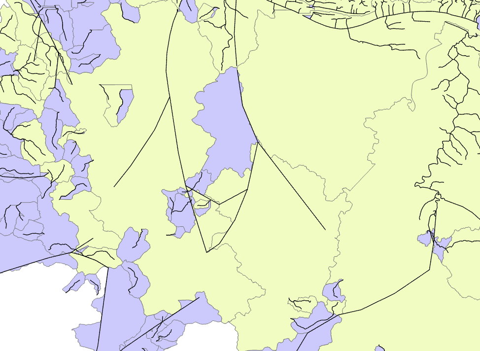
Was wondering if you ever had run into issues with holes in the AdjointCatchment feature class? The Catchment feature class has -1 as the NextDownID, which would be expected on the edge of a watershed, but these are in the middle of the watershed. It's obviously affecting the watershed delineation.
I thought it had something to do with the streams layer including the underground conduit (the straight lines in the attached image), but I removed those and tried running but got the same result.
Any ideas on what to try?
Annina
Purple: Catchments; Yellow: AdjointCatchments; Black lines: DrainageLines
- Mark as New
- Bookmark
- Subscribe
- Mute
- Subscribe to RSS Feed
- Permalink
Annina,
I don't recall seeing that recently.
First: I assume you have filled the sinks under the DEM Manipulation tools.. If not, make sure you do that.
Second: The black lines (DrainageLines) appear to cross each other. Some look like they follow flow paths defined by the DEM (irregular in alignments), others look long and sweeping and like they wouldn't follow a path defined by the DEM. These appear to have have more generalized alignments. Make sure your agreestream layer is correct. I try to limit the agreestream polylines in natural area and only put them in where the DEM misses where water flows under roads or bridges. In developed areas, I put in agreestream polylines where there are pipes.
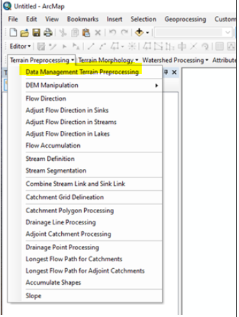
Third: Make sure you are setting the datasets correctly in the Terrain Processing>Data Management Terrain Processing menu.
Hope this helps.
Mark
- Mark as New
- Bookmark
- Subscribe
- Mute
- Subscribe to RSS Feed
- Permalink
Thanks, Mark. I got it figured out; those unnaturally straight lines were the culprit. They are underground pipes, and not useful for my purpose. Weirdly, though, before I asked for input, I removed them and tried running the workflow, but I got the same weird behavior. So, I decided to try again; I removed those underground pipes again, saved, closed out of all Esri products, ended all Esri processes still running in Task Manager, and then ran my workflow again (I've a script that runs the ArcHydro tools I need sequentially). Of course, it worked then.
The things you suggested are going in my back pocket, for when something else doesn't work. Especially the "Data Management Terrain Preprocessing." I didn't know that this existed. Since everything is set in our script, I don't have to worry about this. But, often, the script doesn't work (spontaneously--it's great fun when this happens), and I have to run things individually. It may be helpful to set these!
Thanks again.
- Mark as New
- Bookmark
- Subscribe
- Mute
- Subscribe to RSS Feed
- Permalink
You may be aware that ESRI is moving GeoNet to a new platform. To preserve this thread I've exported it to a Word Document. The option to export to a pdf wasn't working and it looks like some paragraph numbering was lost in the simple copy/paste to Word.
Once the new GeoNet is up and running, and if we last this thread, I will post the document somewhere I think it is searchable.
Best,
Mark - Original Arc Hydro Problem Solvers poster.