- Home
- :
- All Communities
- :
- Industries
- :
- Water Resources
- :
- Water Resources Blog
- :
- What Flow Accumulation Threshold Should I Use?
What Flow Accumulation Threshold Should I Use?


- Subscribe to RSS Feed
- Mark as New
- Mark as Read
- Bookmark
- Subscribe
- Printer Friendly Page
An older version of this blog references USGS WaterWatch as the source for runoff data for the Create Runoff Raster geoprocessing tool. The tool and blog have been updated to use a higher resolution global runoff dataset from TerraClimate.
Background
The delineation and analysis of stream networks within a Geographic Information System (GIS) environment is a foundational task in hydrologic and terrain analysis. These networks serve as a spatial framework for modeling water flow, watershed boundaries, and surface‑hydrology processes. While creating stream networks can be computationally intensive and methodologically complex, the benefits they provide to spatial analysis and environmental modeling are substantial.
In typical GIS workflows, stream networks are derived from Digital Elevation Models (DEMs) through a sequence of hydrologic‑processing steps: depression filling, flow‑direction modeling, flow accumulation, and stream thresholding. Among these, defining the stream‑initiation threshold, the minimum contributing area required for a channel to be considered a stream, is particularly challenging and highly context‑dependent.

Many users ask for the “perfect” threshold for their area of interest, but no universal value applies across all landscapes. The appropriate threshold varies with regional precipitation patterns, soil permeability, vegetation cover, topographic relief, and underlying geology. For example, in arid or semi‑arid environments, surface runoff is less frequent and tends to concentrate in fewer, more episodic channels, necessitating a higher flow‑accumulation threshold to define meaningful stream features. Conversely, in humid or low‑relief regions, shallow overland flow may form continuous drainage paths with relatively low contributing areas, requiring a lower threshold for accurate representation.
Our approach to stream delineation is grounded in methodology developed by the U.S. Geological Survey (USGS) to provide a consistent, hydrologically-based means of stream network delineation. Specifically, it draws from “Flow-Based Method for Stream Generation in a GIS” by Michael E. Wieczorek (USGS, 2017), which introduces a GIS-based workflow for generating stream networks based on estimated flow values, rather than arbitrary area accumulation thresholds alone. This method leverages publicly available runoff data in conjunction with DEMs to produce stream networks that correspond to a defined flow threshold; as stated above, there is no “perfect” threshold, but by default the tool uses a flow threshold of 1 cubic foot a second. By anchoring delineation in hydrologic criteria, this technique improves consistency and interpretability across landscapes and provides a scientifically robust alternative to more subjective, area accumulation based approaches.
New Arc Hydro Tools
To incorporate more physical and climatic factors into stream delineation, Arc Hydro the free add-in for ArcGIS Pro, now includes two geoprocessing tools:
- Create Runoff Raster
- Create Streams with Flow Threshold

Together, these tools implement the USGS flow-based method. Instead of defining streams by a set number of upstream cells, this approach uses actual runoff data and flowrate estimates to determine where streams initiate.
The workflow begins by calculating annual runoff data, and converting it into a raster with the same resolution as the DEM. A flow grid is then created using the DEM and the runoff raster via a flow accumulation function, with the runoff raster serving as the weight raster. This results in a grid where each cell represents the total volume of water that flows into it in a year.
These yearly flow values are converted to traditional flow rates cubic feet per second (cfs) or cubic meters per second (cms) via map algebra. Analysts can then apply an absolute hydrologic threshold (e.g., 1 cfs) to define where streams begin, rather than relying on relative cell counts. Thresholds may be based on mean, median, seasonal, or event‑based flows, allowing a flexible yet standardized approach across diverse regions.
Create Runoff Raster
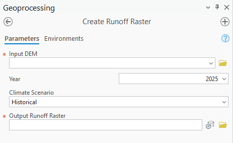
This tool downloads runoff values for a defined area of interest and a selected year, and converts them into a raster with the same extent, cell size, and projection as the input DEM. The runoff data comes from TerraClimate, a dataset of monthly climate and climatic water balance for global terrestrial surfaces from 1950-present. These data provide important inputs for ecological and hydrological studies at global scales that require high spatial resolution and time-varying data. All data have monthly temporal resolution and a ~4-km (1/24th degree) spatial resolution and is updated annually.
Create Streams with Flow Threshold
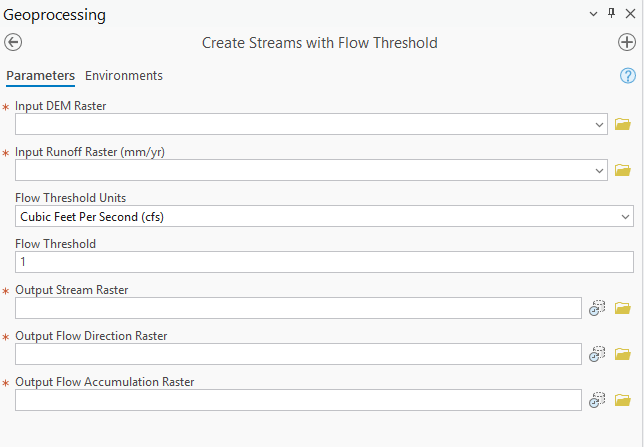
This tool produces a binary stream raster by calculating flow direction and flow accumulation from the DEM, weighing those results with the runoff raster to generate pixel values representing flow (volume per time). The Flow Threshold parameter defines the minimum runoff required for a cell to qualify as a stream. The default value is 1 cfs, as recommended by the USGS, but you can adjust it to obtain denser or sparser networks.
Practical Use Case
Below is a streamlined example of generating a runoff‑based stream network. The only prerequisite is a DEM. (If you need one, use the Download DEM Arc Hydro tool)

Step 1– Create Runoff Raster
Run Create Runoff Raster with your DEM as Input DEM Raster and select the year of interest.


Step 2 – Create Streams with Flow Threshold
Run Create Streams with Flow Threshold, using:
- Input DEM Raster: the same DEM as in Step 1
- Input Runoff Raster: the runoff raster from Step 1
- Flow Threshold: leave at 1 cfs or modify as needed

The output stream raster (Str.tif in this case) may appear subtle at small scales; zooming in reveals the derived stream network.

Step 3–Convert To Vector (Optional)
Optionally run Stream to Feature to convert the raster network to vector features.


In just three geoprocessing steps, local runoff data was incorporated into terrain data to derive a stream network.
Why Two Separate Tools?
To maximize flexibility, the stream derivation workflow was intentionally split into two geoprocessing tools. This allows analysts to use their own runoff data, especially those working with higher resolution datasets. While such users may skip the Create Runoff Raster tool, they can still fully leverage Create Streams with Flow Threshold to generate stream networks. By decoupling the tools, the workflow supports a broader range of hydrologic data beyond TerraClimate.
Conclusion
Defining a flow accumulation threshold for stream network delineation has long challenged hydrologic GIS practitioners. Traditional, arbitrary cell count thresholds often fail across landscapes with varying climate, terrain, and hydrology. By leveraging Create Runoff Raster and Create Streams with Flow Threshold, analysts now have an objective, data driven method for stream initiation, anchored in actual runoff and flow measurements.
This flow-based approach enhances the consistency, transparency, and reproducibility of derived networks, whether you work in steep alpine basins or low relief floodplains. As hydrologic modeling evolves, integrating real world data into GIS workflows will be essential. These Arc Hydro tools help bridge that gap, enabling stream networks that more accurately represent landscape processes. We encourage GIS professionals, researchers, and resource managers to explore this methodology and share feedback to refine and expand its utility.
Additional Notes
Software Requirements: Both tools use functions from the ArcGIS Spatial Analyst and ArcGIS Image Analyst extension; ensure you have valid licenses.
You must be a registered user to add a comment. If you've already registered, sign in. Otherwise, register and sign in.

