- Home
- :
- All Communities
- :
- User Groups
- :
- Training in GIS
- :
- Questions
- :
- Re: GIS EXAM
- Subscribe to RSS Feed
- Mark Topic as New
- Mark Topic as Read
- Float this Topic for Current User
- Bookmark
- Subscribe
- Mute
- Printer Friendly Page
GIS EXAM
- Mark as New
- Bookmark
- Subscribe
- Mute
- Subscribe to RSS Feed
- Permalink
I have an upcoming exam which asks the following question. The supplied textbooks do not cover this subject. Any help would be greatly appreciated.
You are asked to prepare a map that shows the forest lands that are suitable for harvesting. The lands must not be: 1) within 300 feet of roads and 2)within 500 feet of streams. You are given three digital maps showings roads, streams and forest stands, respectively. Describe the procedure (steps, required data, queries and spatial operations, and output) that you will use to complete the task. Draw a flowchart to show the steps?
- Mark as New
- Bookmark
- Subscribe
- Mute
- Subscribe to RSS Feed
- Permalink
You could do something like this using ArcMap (Buffer and Erase tools).
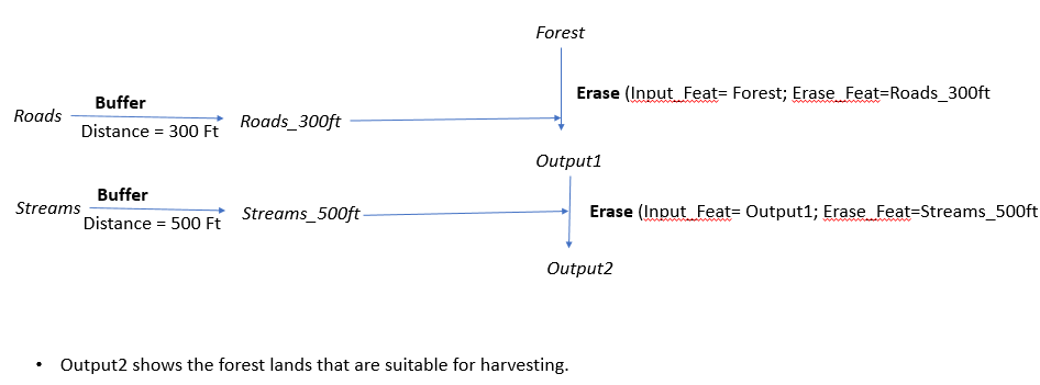
Think Location
- Mark as New
- Bookmark
- Subscribe
- Mute
- Subscribe to RSS Feed
- Permalink
Thank you! The exam is on the theory of GIS more than the practical side. Any other help would be greatly appreciated! If not, thanks again!!
- Mark as New
- Bookmark
- Subscribe
- Mute
- Subscribe to RSS Feed
- Permalink
To prepare for this exam, I would recommend researching Spatial Overlay Analysis topics.
Overlay analysis—Help | ArcGIS for Desktop
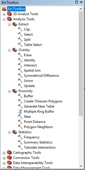
Also, assuming you are using ArcGIS, I would look at the Geoprocessing tools in the Analysis Tools section of ArcToolbox, as there are several that would work in answering the question you posed (there is more than one way to do this with those tools). Open the tool, then click on the Tool Help button to open a windown with information on what it does. Note that what tools you have available will vary depending upon what licensing you have.
Chris Donohue, GISP