- Home
- :
- All Communities
- :
- Industries
- :
- Transportation
- :
- Roads and Highways
- :
- Roads and Highways Questions
- :
- Re: How to change field type in Excel before impor...
- Subscribe to RSS Feed
- Mark Topic as New
- Mark Topic as Read
- Float this Topic for Current User
- Bookmark
- Subscribe
- Mute
- Printer Friendly Page
How to change field type in Excel before importing?
- Mark as New
- Bookmark
- Subscribe
- Mute
- Subscribe to RSS Feed
- Permalink
Hello everyone!
I'm currently trying to calibrate stationing along a highway, but I need the stationing to be straight numbers ("54000" instead of the typical "540+00"). I have an Excel document that the correct formatting is in, and I thought I'd join it with our current stationing shapefile, but when I import it into ArcMAP, the field is automatically changed to a string. I need it to be a number field. That's the only way the calibrate tool will work. Any suggestions would be greatly appreciated!
Things I've tried:
Changing field type from ArcCatalog (which I found you can't change from text to number)
Setting the type in Excel to number
EDIT: I fixed it myself. Apparently if you save your Excel document as a .csv first, then import it, ArcMAP will automatically make the field numeric.
- Mark as New
- Bookmark
- Subscribe
- Mute
- Subscribe to RSS Feed
- Permalink
You say the spreadsheet has the 'correct formatting'. Which is correct: 5400 or 54+00?
I'm getting lost with your terminology and methodology:
I thought I'd join it with our current stationing shapefile.... What is the keyfield with which you are joining the excel spreadsheet and the shapefile ?(I hope you mean feature class, shapefiles are so 90's)
but when I import it into ArcMAP... What do you mean by import? Import is a specific method with which to transfer data from one database to another. For example you import Table X into A.gdb from B.gdb. Do you really mean when I add my spreadsheet as a table to an ArcMap session?
If you can clarify what you have and what you are doing, we might be able to help you.
- Mark as New
- Bookmark
- Subscribe
- Mute
- Subscribe to RSS Feed
- Permalink
Well you can still fix it using the field calculator in Arcmap
>>> a
'540+00'
>>> "{}{}".format(*(a.split("+")))
'54000'
>>> b = int("{}{}".format(*(a.split("+"))))
>>> b
54000So I am guessing the field calculator expression would be... using the python parser of course
int("{}{}".format(*(!a!.split("+"))))
# where !a! is the field name containing the text enclosed in ! marksworth a shot... you can probably emulate it in excel if you must
- Mark as New
- Bookmark
- Subscribe
- Mute
- Subscribe to RSS Feed
- Permalink
I did use the field Calculator at first, but the field is already Text. That's why I needed to move it over to Excel first.
- Mark as New
- Bookmark
- Subscribe
- Mute
- Subscribe to RSS Feed
- Permalink
add a new integer (long field)... and do the calculation in it... the !a! field is the one containing the text
- Mark as New
- Bookmark
- Subscribe
- Mute
- Subscribe to RSS Feed
- Permalink
"540+00" is interpreted by ArcGIS as a string no matter what you tell Excel the format is, because it contains a non-numerical character. ArcGIS will interpret "54000" as a number, so you can either change it in Excel or import it as a string into ArcGIS and change it as Dan suggests.
- Mark as New
- Bookmark
- Subscribe
- Mute
- Subscribe to RSS Feed
- Permalink
Then add a field called StationID_Int and calculate it's value with Dan's method...
- Mark as New
- Bookmark
- Subscribe
- Mute
- Subscribe to RSS Feed
- Permalink
Joe.... I suspect interest is lost since it was marked "assumed answered"
- Mark as New
- Bookmark
- Subscribe
- Mute
- Subscribe to RSS Feed
- Permalink
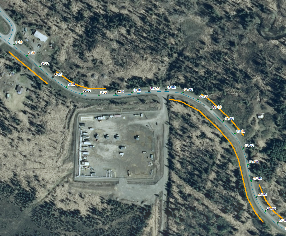
I was able to get it fixed myself, but I want to keep all these answers up here in case they help someone else. This was the final result from my project:

I had to keep the stationing with the '+' in one field so I could label with it, but the actual calibrated route refers to the stationing without the '+'. And then, of course, so do the orange lines. They were created by inserting a table with start and end stationing, and then displaying route events. I'm really glad I got this figured out because I feel it's something our geologists want fairly frequently but are unsure of the process. I will probably skip using Excel next time now that I know you can cross reference fields in the Field Calculator.
- Mark as New
- Bookmark
- Subscribe
- Mute
- Subscribe to RSS Feed
- Permalink
In case people are not aware: Excel determines numeric/date/text columns based upon some first number of rows -- There is nothing inside excel you can do with this behavior. For this reason, I always export the data as text to Access then format as necessary. If it is data I have to deal with alot then I make template access tables with correct formatting.
A word to the wise -- Never trust an excel export or link!