- Home
- :
- All Communities
- :
- Developers
- :
- Python
- :
- Python Questions
- :
- Using Python to replicate the Export Data command
- Subscribe to RSS Feed
- Mark Topic as New
- Mark Topic as Read
- Float this Topic for Current User
- Bookmark
- Subscribe
- Mute
- Printer Friendly Page
Using Python to replicate the Export Data command
- Mark as New
- Bookmark
- Subscribe
- Mute
- Subscribe to RSS Feed
- Permalink
Complete newbie here looking for some assistance. I need to convert a shapefile into a KML file and as i do this often was looking at Python to automate it. The shapefile has a join to another database to keep it dynamic so i am having to use the "export data" to make a shapefile which i then amend the field name (alias's) and convert to KML. I have tried the featureclasstofeatureclass_conversion command but this renames the fieldnames? I have then tried makefeaturelayermanagement command but this doesnt bring across the joined fields?
- Mark as New
- Bookmark
- Subscribe
- Mute
- Subscribe to RSS Feed
- Permalink
I worked earlier... geonet is burping again... I will check later
in text form with gaps... http: // desktop.arcgis.com/en/arcmap/latest/tools/conversion-toolbox/feature-class-to-feature-class. htm
- Mark as New
- Bookmark
- Subscribe
- Mute
- Subscribe to RSS Feed
- Permalink
Have you tried doing these steps in model builder. If you are new to python it may be simpler to work out the process in model builder then ease into python.
What is ModelBuilder?—Help | ArcGIS for Desktop
Add Join—Help | ArcGIS for Desktop
FC2FC that Dan mentions
- Mark as New
- Bookmark
- Subscribe
- Mute
- Subscribe to RSS Feed
- Permalink
Also, don't overlook getting it to work "manually" thru the tool, then open the Tools-Geoprocessing-Python window, find the successful tool and "copy as snippet" or just "save" it to a file. That helps in seeing how the command have it laid out, and it's then relatively easy to convert this to a python script/tool. In any case, as Dan mentioned, it would give others a look at what you are trying to do, which make help with more direct feedback.
- Mark as New
- Bookmark
- Subscribe
- Mute
- Subscribe to RSS Feed
- Permalink
Hi Rebecca,
Not sure if don't have a badly installed copy or am just missing stuff.
I Don't have a tool menu. I have a geoprocessing menu and a python window but when i open this it is blank (This is where i have been entering my code)
If there is a feature when i can copy the code that has been generated by my manual operations that would be awesome
Did i mention that i am very new to Python and fairly new to arcGIS 🙂
- Mark as New
- Bookmark
- Subscribe
- Mute
- Subscribe to RSS Feed
- Permalink
Sorry Phil...was typing from memory which can be stuck in older programs. The Geoprocessing toolbox is where you will find the Python window option....but what I REALLY wanted to point you to is the RESULTs window under Geoprocessing. The "save as" is if you ran it in the
After you run a script, and it is successful, you can right click on the name of the tool in the Results window and "Copy as python snippet".
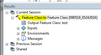
This may look intimidating sometimes...but see the snippet, and what you really need (minimum) to get it to run...
#  from the copy from snippet...
arcpy.FeatureClassToFeatureClass_conversion(in_features="D:/___111136Cbu/WorkSpace/2004-05Hunts.mdb/bison_region_hunts", out_path="C:/__temp/test.gdb", out_name="test", where_clause="", field_mapping="""HUNTNO "HUNTNO" true true false 5 Text 0 0 ,First,#,D:\___111136Cbu\WorkSpace\2004-05Hunts.mdb\bison_region_hunts,HUNTNO,-1,-1;RELATED "RELATED" true true false 50 Text 0 0 ,First,#,D:\___111136Cbu\WorkSpace\2004-05Hunts.mdb\bison_region_hunts,RELATED,-1,-1;HUNTLABEL1 "LABEL1" true true false 25 Text 0 0 ,First,#,D:\___111136Cbu\WorkSpace\2004-05Hunts.mdb\bison_region_hunts,HUNTLABEL1,-1,-1;HUNTLABEL2 "LABEL2" true true false 25 Text 0 0 ,First,#,D:\___111136Cbu\WorkSpace\2004-05Hunts.mdb\bison_region_hunts,HUNTLABEL2,-1,-1;UNIT "UNIT" true true false 2 Text 0 0 ,First,#,D:\___111136Cbu\WorkSpace\2004-05Hunts.mdb\bison_region_hunts,UNIT,-1,-1;SUBUNIT "SUBUNIT" true true false 1 Text 0 0 ,First,#,D:\___111136Cbu\WorkSpace\2004-05Hunts.mdb\bison_region_hunts,SUBUNIT,-1,-1;REGION "REGION" true true false 2 Short 0 0 ,First,#,D:\___111136Cbu\WorkSpace\2004-05Hunts.mdb\bison_region_hunts,REGION,-1,-1;HUNTTYPE "HUNTTYPE" true true false 1 Text 0 0 ,First,#,D:\___111136Cbu\WorkSpace\2004-05Hunts.mdb\bison_region_hunts,HUNTTYPE,-1,-1;DESC_ "DESCRIPTION" true true false 50 Text 0 0 ,First,#,D:\___111136Cbu\WorkSpace\2004-05Hunts.mdb\bison_region_hunts,DESC_,-1,-1;COMMENTS "COMMENTS" true true false 40 Text 0 0 ,First,#,D:\___111136Cbu\WorkSpace\2004-05Hunts.mdb\bison_region_hunts,COMMENTS,-1,-1;SHAPE_Length "SHAPE_Length" false true true 8 Double 0 0 ,First,#,D:\___111136Cbu\WorkSpace\2004-05Hunts.mdb\bison_region_hunts,SHAPE_Length,-1,-1;SHAPE_Area "SHAPE_Area" false true true 8 Double 0 0 ,First,#,D:\___111136Cbu\WorkSpace\2004-05Hunts.mdb\bison_region_hunts,SHAPE_Area,-1,-1""", config_keyword="")

# what you really need from this is only required items...unless you are changing some mapping
arcpy.FeatureClassToFeatureClass_conversion(r'D:\___111136Cbu\WorkSpace\2004-05Hunts.mdb\bison_region_hunts', r'C:\__temp\test.gdb', "testout2")
The SaveAs is from the python window, if you are running from that, and will have a cleaner look, similar to the last line in the above.
Again, my apologies for confusing you...hope this makes more sense.
- Mark as New
- Bookmark
- Subscribe
- Mute
- Subscribe to RSS Feed
- Permalink
Gee Rebecca,
I would be intimidated by that as well
- Mark as New
- Bookmark
- Subscribe
- Mute
- Subscribe to RSS Feed
- Permalink
Lol. Ya Neil....drives me nuts that it has to list all of the field mappings and other arguments, even if the don't change or are default. First thing I do is strip down to the minimum....or if I DO need things like the field mapping, pushing it off to a variable that I can use.....the full snippet is almost unreadable and probably does scare many off. Too bad too....it's a great tool. 
- Mark as New
- Bookmark
- Subscribe
- Mute
- Subscribe to RSS Feed
- Permalink
A general solution to this problem can be found here: https://desktop.arcgis.com/en/arcmap/10.7/tools/environments/qualified-field-names.htm
simply add:
arcpy.env.qualifiedFieldNames = False
at the beginning of your script and the joined field names will not be renamed when exporting the data using e.g. arcpy.CopyFeatures_management.
- « Previous
-
- 1
- 2
- Next »
- « Previous
-
- 1
- 2
- Next »