- Home
- :
- All Communities
- :
- Developers
- :
- Python
- :
- Python Questions
- :
- Export TIF to PNG that display elevation as RGB co...
- Subscribe to RSS Feed
- Mark Topic as New
- Mark Topic as Read
- Float this Topic for Current User
- Bookmark
- Subscribe
- Mute
- Printer Friendly Page
Export TIF to PNG that display elevation as RGB color
- Mark as New
- Bookmark
- Subscribe
- Mute
- Subscribe to RSS Feed
- Permalink
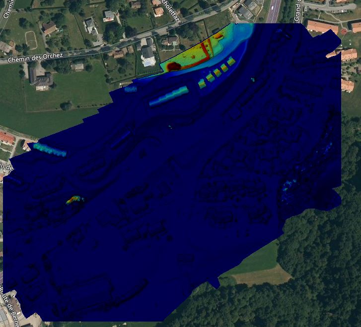
I'm currently want write an Arcpy script to achieve the elevation map from TIF, look like this
Currently i have the output of Pix4D that contains: DSM, DTM, Orthomosaic, Tiles etc.. But i don't know where to start. I really appreciate all of your helps. Have a nice day
- Mark as New
- Bookmark
- Subscribe
- Mute
- Subscribe to RSS Feed
- Permalink
Well if you have what you want as shown... perhaps you can either use the existing functionality built into arcmap
ExportToPNG—Help | ArcGIS Desktop
and look at the code snippet at the bottom should you wish to refine and/or automate the process
- Mark as New
- Bookmark
- Subscribe
- Mute
- Subscribe to RSS Feed
- Permalink
Well in fact, the picture above is the result that i want to achieve but i haven't known how to do yet, i just have the DSM, DTM, orthomosaic which are the output from Pix4d after processing my images capturing from my drone. You have any idea, Mr.Patterson ?
- Mark as New
- Bookmark
- Subscribe
- Mute
- Subscribe to RSS Feed
- Permalink
Confusion on my part... I just thought you want to convert that output to png, but you haven't gotten that far yet... sorry.
- Mark as New
- Bookmark
- Subscribe
- Mute
- Subscribe to RSS Feed
- Permalink
No problem, thank you very much, Mr.Patterson