- Home
- :
- All Communities
- :
- Developers
- :
- Python
- :
- Python Questions
- :
- DTM AND DSM
- Subscribe to RSS Feed
- Mark Topic as New
- Mark Topic as Read
- Float this Topic for Current User
- Bookmark
- Subscribe
- Mute
- Printer Friendly Page
DTM AND DSM
- Mark as New
- Bookmark
- Subscribe
- Mute
- Subscribe to RSS Feed
- Permalink
how could import dtm and dsm on gis 10.4.1?
- Mark as New
- Bookmark
- Subscribe
- Mute
- Subscribe to RSS Feed
- Permalink
Are there any restrictions in your location on downloading videos?
can you download any videos and view them?
Are you trying to access them from home or work?
- Mark as New
- Bookmark
- Subscribe
- Mute
- Subscribe to RSS Feed
- Permalink
look if are....
- Mark as New
- Bookmark
- Subscribe
- Mute
- Subscribe to RSS Feed
- Permalink
If your account is linked to an organization that has ArcGIS Software on maintenance there will be many more resources available to you.
If not, as Dan mentioned before you can see some videos on Youtube and for instance this video came up: Terrain Analysis Exercise 1: Calculating Terrain Attributes - YouTube (when I searched for "terrain analysis ArcGIS"). Although it references a tutorial related to LiDAR data, you can see how slope, aspect and other products are derived.
- Mark as New
- Bookmark
- Subscribe
- Mute
- Subscribe to RSS Feed
- Permalink
In addition this explanation form the Help page:
Many e-Learning resources in our catalog are open to everyone. These resources are indicated with the “FREE” label. To take any of the free e-Learning resources, you simply need to login with your Esri Account.
Individuals who have, or are members of an organization that has, an Esri qualifying product with a current maintenance subscription have unlimited access to all e-Learning resources in our catalog. Learn how to take advantage of this benefit.
- Mark as New
- Bookmark
- Subscribe
- Mute
- Subscribe to RSS Feed
- Permalink
HI XANDER
COULD SEND ME THE ORIGINALLY VIDEO OF THIS VISUALLY
- Mark as New
- Bookmark
- Subscribe
- Mute
- Subscribe to RSS Feed
- Permalink
What video are you referring to? Is it this one that I included 7 months ago? Terrain Analysis Exercise 1: Calculating Terrain Attributes - YouTube
- Mark as New
- Bookmark
- Subscribe
- Mute
- Subscribe to RSS Feed
- Permalink
hi Xander
i want to see this video....could you help?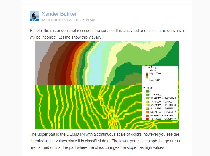
- Mark as New
- Bookmark
- Subscribe
- Mute
- Subscribe to RSS Feed
- Permalink
I don't have a video of that process, but the steps would be very simple. The problem is that the file that you have does not have valid data to generate the slope map. Unless, you have a different data set now (a lot can happen in 7 months).
- Mark as New
- Bookmark
- Subscribe
- Mute
- Subscribe to RSS Feed
- Permalink
Can you share the location of the raster? It would be best to ask those that provided the raster what coordinate system has been used to avoid having to guess the spatial reference.