- Home
- :
- All Communities
- :
- Industries
- :
- Transportation
- :
- Public Transit
- :
- Public Transit Questions
- :
- Mapping transit accessibility to jobs
- Subscribe to RSS Feed
- Mark Topic as New
- Mark Topic as Read
- Float this Topic for Current User
- Bookmark
- Subscribe
- Mute
- Printer Friendly Page
Mapping transit accessibility to jobs
- Mark as New
- Bookmark
- Subscribe
- Mute
- Subscribe to RSS Feed
- Permalink
Hi everyone! I am still new to ArcGIS and am working on it, and would really appreciate your help on this. My company is working on an urban development project in one of the developing countries but has limited datasets on jobs and transit schedule provided by the client.
For jobs data, we do not have locations of jobs, which causes the main issue here. I wonder if anyone has dealt with the same issue and could propose any creative assumptions we could make alternatively.
For transit schedule, we have travel speed, line routes and stop points, but key mandatory files to compose accurate GTFS data including departure/arrival time, calendar dates..etc. are impossible to attain.
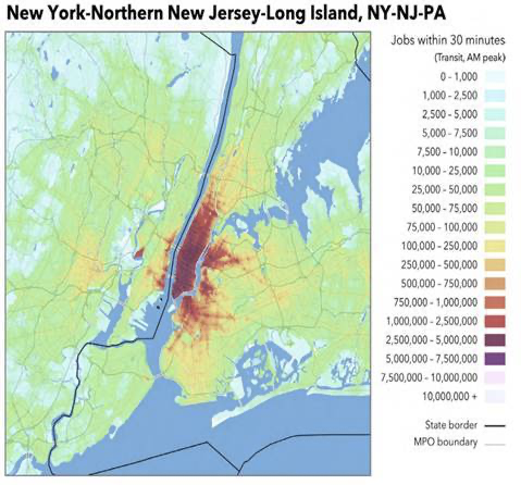
We are trying to find out how many people are accessible to jobs opportunities within 60-minute time.. something that looks similar to the map below (https://medium.com/@emilyeros/accessibility-analysis-for-more-informed-transport-planning-some-local... ) Is there any way we could run a simple accessibility analysis with only using open source data?
Any comments would be appreciated! Thanks 