- Home
- :
- All Communities
- :
- Industries
- :
- Transportation
- :
- Public Transit
- :
- Public Transit Questions
- :
- Count Trips in Polygon Buffers Around Stops
- Subscribe to RSS Feed
- Mark Topic as New
- Mark Topic as Read
- Float this Topic for Current User
- Bookmark
- Subscribe
- Mute
- Printer Friendly Page
- Mark as New
- Bookmark
- Subscribe
- Mute
- Subscribe to RSS Feed
- Permalink
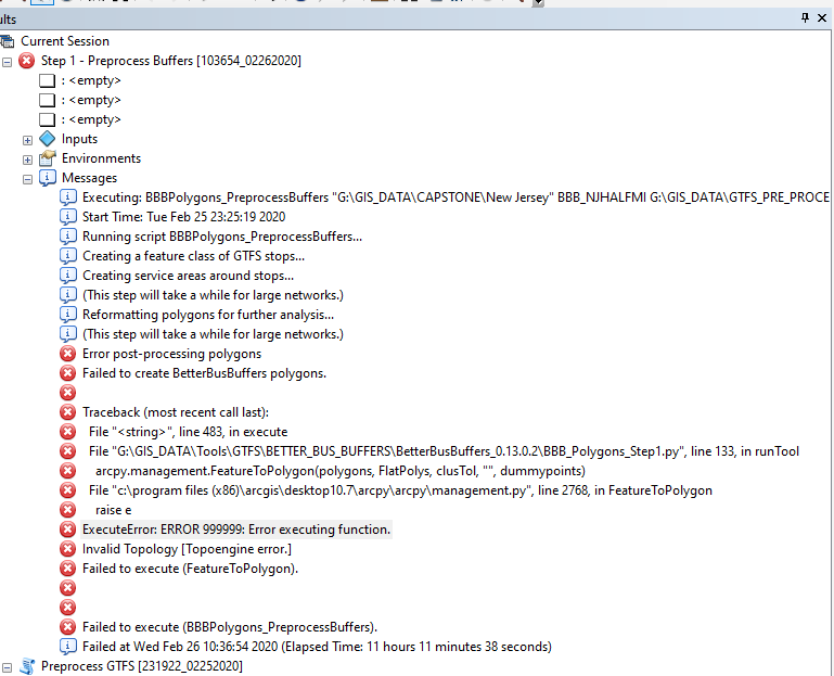
Can't seem to get the data to pre-process. I am using GTFS bus data supplied by NJT. Anyone familiar with this error or what is happening?
Solved! Go to Solution.
Accepted Solutions
- Mark as New
- Bookmark
- Subscribe
- Mute
- Subscribe to RSS Feed
- Permalink
As you can see from the error traceback, the BetterBusBuffers tool is failing when it runs the FeatureToPolygon tool. This is one of several internal steps that the BetterBusBuffers tool does. The tool calculates Service Area polygons around all the transit stops and then post-process those polygons using several other geoprocessing tools, including FeatureToPolygon. For some reason, this tool is not able to run successfully on the inputs it's getting from the Service Area polygons. My guess is that the geometry created by the Service Area polygons has something degenerate in it that is causing geometry errors later.
I think the only option you really have is to change the BetterBusBuffers tool settings so that the Service Area polygon geometry is different, with the hopes that the degenerate polygons go away. Here are some ways to do impact the output polygon shapes:
- Run the analysis in ArcGIS Pro (Pro uses a newer and better polygon generation algorithm)
- Use a different network dataset
- Use different network analysis settings (impedance attribute or restrictions)
- Use a different buffer size
- Use a different polygon trim
If you have access to ArcGIS Pro, that would be the best thing to try first since you can maintain all of your other analysis settings.
If not, adjusting the polygon trim is probably the simplest and will impact your analysis results the least. It might not resolve the issue, but it's worth a try.