- Home
- :
- All Communities
- :
- Products
- :
- Oriented Imagery
- :
- Oriented Imagery Classic
- :
- What metadata is needed to use measurement tools i...
- Subscribe to RSS Feed
- Mark Topic as New
- Mark Topic as Read
- Float this Topic for Current User
- Bookmark
- Subscribe
- Mute
- Printer Friendly Page
What metadata is needed to use measurement tools in Oriented Imagery Viewer?
- Mark as New
- Bookmark
- Subscribe
- Mute
- Subscribe to RSS Feed
- Permalink
Hi all,
I've been trying to figure what metadata is needed to be able to use measurement tools in Oriented Imagery Viewer. I've created an Oriented Imagery catalog from aerial oblique imagery service (https://sampleserver6.arcgisonline.com/arcgis/rest/services/Oblique/WU_Oblique/ImageServer) . Looking at the resulting exposure points - they have CamOri field with detailed camera orientation. I've also used DEM service when I created this catalog. But I'm still unable to use measurement tools with this oriented imagery catalog:

This is the content of the oic:
{"type": "OIC", "version": "2.1", "properties": {"Name": "test8", "Description": "test", "Tags": "OrientedImagery", "ServiceURL": "https://services6.arcgis.com/YtqGNFEdrYd1pjuW/arcgis/rest/services/test8_ExposurePoints/FeatureServer/1", "OverviewURL": "https://tiles.arcgis.com/tiles/YtqGNFEdrYd1pjuW/arcgis/rest/services/test8_CoverageMap/VectorTileServer", "DefaultAttributes": {"CamHeading": "", "CamPitch": "", "CamRoll": "0", "HFOV": "", "VFOV": "", "AvgHtAG": "", "FarDist": "", "NearDist": "", "OIType": "T", "SortOrder": "", "CamOffset": "", "Accuracy": "", "ImgPyramids": "", "DepthImg": "", "ExternalViewer": "", "ImgRot": "", "ImageryType": "Aerial Oblique Camera"}, "About": "", "ImageField": "", "ImagePrefix": "", "VideoPrefix": "", "DepthImagePrefix": "", "SourceImagePrefix": "", "MaxDistance": "", "DEMPrefix": "I||https://elevation3d.arcgis.com/arcgis/rest/services/WorldElevation3D/Terrain3D/ImageServer", "Credentials": {"Username": "", "Password": ""}, "Variables": {}, "Filters": {}, "Copyright": {"text": "test", "url": ""}, "PointsSource": "D:\\Temp\\oblique\\oblique\\orient_test\\test8.gdb\\test8_ExposurePoints", "CoverageSource": "D:\\Temp\\oblique\\oblique\\orient_test\\test8.gdb\\test8_CoverageMap"}}
What data is needed for the measurement functions in OI Viewer to be available?
Thank you,
Tadas
Solved! Go to Solution.
- Mark as New
- Bookmark
- Subscribe
- Mute
- Subscribe to RSS Feed
- Permalink
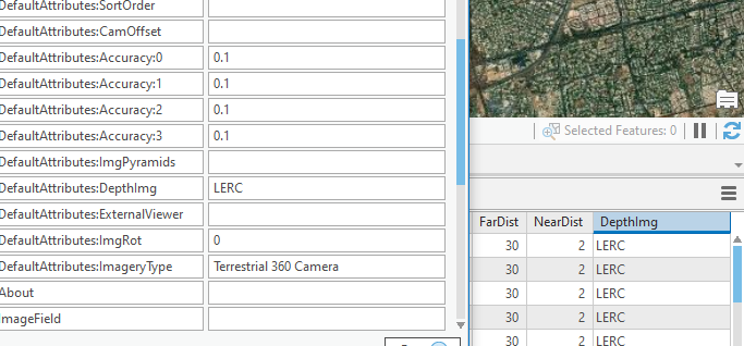
For distance and area tool to be activated, you need depth image defined in the feature service.
If you have a depth image, then you can define it in DepthImg field in the feature class.
See the documentation - oriented-imagery/OrientedImageryCatalog_Schema.pdf at master · Esri/oriented-imagery · GitHub
Snippet

- Mark as New
- Bookmark
- Subscribe
- Mute
- Subscribe to RSS Feed
- Permalink
As I understand it, should I add a column named depthImg in the CSV that I
add in 'add images to oriened imagery catalog' or just add it at the
attribute table ?
I have images with jpg extension, what is the definition that I can add to
the depthImg field? such that i tried with JPEG, JPG and PNG and it
doesn't work.
Le mer. 30 sept. 2020 à 17:45, Kushagra Patel <geonet@esri.com> a écrit :
GeoNet, The Esri Community | GIS and Geospatial Professional Community
<https://community.esri.com/?et=watches.email.thread>
Re: What metadata is needed to use measurement tools in Oriented Imagery
Viewer?
reply from Kushagra Patel
<https://community.esri.com/people/Kushagra_Patel-esristaff?et=watches.email.thread>
in Imagery and Remote Sensing - View the full discussion
<https://community.esri.com/message/956502-re-what-metadata-is-needed-to-use-measurement-tools-in-oriented-imagery-viewer?commentID=956502&et=watches.email.thread#comment-956502>
- Mark as New
- Bookmark
- Subscribe
- Mute
- Subscribe to RSS Feed
- Permalink
You can define it in CSV or just add to the attribute table also. Both approaches should work.
For depth images, the extensions we support are LERC and MRF.
- Mark as New
- Bookmark
- Subscribe
- Mute
- Subscribe to RSS Feed
- Permalink
So add in attribute table a field named DepthImg and put MRF or LERC in all
cases? That's it? And add the same value in depthImg property?
Another question, if what i say is correct, i will re-publish the catalog
directly or will i re run the feature coverage and coverage map?
Le jeu. 1 oct. 2020 à 17:00, Kushagra Patel <geonet@esri.com> a écrit :
GeoNet, The Esri Community | GIS and Geospatial Professional Community
<https://community.esri.com/?et=watches.email.thread>
Re: What metadata is needed to use measurement tools in Oriented Imagery
Viewer?
reply from Kushagra Patel
<https://community.esri.com/people/Kushagra_Patel-esristaff?et=watches.email.thread>
in Imagery and Remote Sensing - View the full discussion
<https://community.esri.com/message/956816-re-what-metadata-is-needed-to-use-measurement-tools-in-oriented-imagery-viewer?commentID=956816&et=watches.email.thread#comment-956816>
- Mark as New
- Bookmark
- Subscribe
- Mute
- Subscribe to RSS Feed
- Permalink
If the depth image is same for all the images, then you can just define it in the properties and republish the OIC.

But if every image has its own depth (which i think is applicable in your case), then you can define in the attribute table. For every record, there will be a depth image. Here, you don't need to define it in the properties.
You need to republish the calalog, but you don't need to compute the feature coverage and coverage polygon again.
- Mark as New
- Bookmark
- Subscribe
- Mute
- Subscribe to RSS Feed
- Permalink
hi,
So what i did is:
1. I add column depth images in exposure points's attribute table. I put
LERC in all fields/cases, and also in depth Image field in OIC Properties.
doesn't work
2. I deleted just LERC from OIC Properties (Depth img field). doesn't work
3. I deleted the column from exposure points's table, and I put LERC in OIC
Properties. doesn't work
I do the same steps with MRF, and i get the same result like using LERC, no
widget was added in oriented imagery Viewer, and the widget of measurement
doesn't show.
Le ven. 2 oct. 2020 à 00:49, Kushagra Patel <geonet@esri.com> a écrit :
GeoNet, The Esri Community | GIS and Geospatial Professional Community
<https://community.esri.com/?et=watches.email.thread>
Re: What metadata is needed to use measurement tools in Oriented Imagery
Viewer?
reply from Kushagra Patel
<https://community.esri.com/people/Kushagra_Patel-esristaff?et=watches.email.thread>
in Imagery and Remote Sensing - View the full discussion
<https://community.esri.com/message/956921-re-what-metadata-is-needed-to-use-measurement-tools-in-oriented-imagery-viewer?commentID=956921&et=watches.email.thread#comment-956921>
- Mark as New
- Bookmark
- Subscribe
- Mute
- Subscribe to RSS Feed
- Permalink
So, I re-try again, and this time I re-run the accuracy, the widget of
measurement is shown.
but distance and area cannot be clicked.
How can I solve this?
Le ven. 2 oct. 2020 à 12:56, Soukaina MENJEL <soukaina.menjel@gmail.com> a
écrit :
hi,
So what i did is:
1. I add column depth images in exposure points's attribute table. I put
LERC in all fields/cases, and also in depth Image field in OIC Properties.
doesn't work
2. I deleted just LERC from OIC Properties (Depth img field). doesn't work
3. I deleted the column from exposure points's table, and I put LERC in
OIC Properties. doesn't work
I do the same steps with MRF, and i get the same result like using LERC,
no widget was added in oriented imagery Viewer, and the widget of
measurement doesn't show.
>
>
Le ven. 2 oct. 2020 à 00:49, Kushagra Patel <geonet@esri.com> a écrit :
>> GeoNet, The Esri Community | GIS and Geospatial Professional Community
>> <https://community.esri.com/?et=watches.email.thread>
>> Re: What metadata is needed to use measurement tools in Oriented Imagery
>> Viewer?
>>
>> reply from Kushagra Patel
>> <https://community.esri.com/people/Kushagra_Patel-esristaff?et=watches.email.thread>
>> in Imagery and Remote Sensing - View the full discussion
>> <https://community.esri.com/message/956921-re-what-metadata-is-needed-to-use-measurement-tools-in-oriented-imagery-viewer?commentID=956921&et=watches.email.thread#comment-956921>
>>
- Mark as New
- Bookmark
- Subscribe
- Mute
- Subscribe to RSS Feed
- Permalink
Hi,
I think you misunderstood what I was trying to convey here or maybe I was not clear enough.
You will require depth images to enable area and distance tool. I think you don't have depth images with you.
Depth image gives you the “depth” of the object or the “z” information of the object in real world.
Let's say you have 100 images in your dataset. So you will require 100 matching images where each pixel represent the distance (depth) of the object from the camera. LERC and MRF are the extensions of the file that we support. You will have to enter the URLs to the depth images in the DepthImg field.
Depth maps can be obtained using stereo camera, triangulation, point cloud, or Lidar data etc.

- Mark as New
- Bookmark
- Subscribe
- Mute
- Subscribe to RSS Feed
- Permalink
I don't have Z information, so what?
Le ven. 2 oct. 2020 à 17:16, Kushagra Patel <geonet@esri.com> a écrit :
GeoNet, The Esri Community | GIS and Geospatial Professional Community
<https://community.esri.com/?et=watches.email.thread>
Re: What metadata is needed to use measurement tools in Oriented Imagery
Viewer?
reply from Kushagra Patel
<https://community.esri.com/people/Kushagra_Patel-esristaff?et=watches.email.thread>
in Imagery and Remote Sensing - View the full discussion
<https://community.esri.com/message/956934-re-what-metadata-is-needed-to-use-measurement-tools-in-oriented-imagery-viewer?commentID=956934&et=watches.email.thread#comment-956934>
- Mark as New
- Bookmark
- Subscribe
- Mute
- Subscribe to RSS Feed
- Permalink
Can you send me an exemple of how to insert information of depth image?
Le ven. 2 oct. 2020 à 21:04, Soukaina MENJEL <soukaina.menjel@gmail.com> a
écrit :
I don't have Z information, so what?
Le ven. 2 oct. 2020 à 17:16, Kushagra Patel <geonet@esri.com> a écrit :
>> GeoNet, The Esri Community | GIS and Geospatial Professional Community
>> <https://community.esri.com/?et=watches.email.thread>
>> Re: What metadata is needed to use measurement tools in Oriented Imagery
>> Viewer?
>>
>> reply from Kushagra Patel
>> <https://community.esri.com/people/Kushagra_Patel-esristaff?et=watches.email.thread>
>> in Imagery and Remote Sensing - View the full discussion
>> <https://community.esri.com/message/956934-re-what-metadata-is-needed-to-use-measurement-tools-in-oriented-imagery-viewer?commentID=956934&et=watches.email.thread#comment-956934>
>>