- Home
- :
- All Communities
- :
- Developers
- :
- Open Source Mapping Libraries
- :
- Open Source Mapping Libraries Ques.
- :
- Demo: NexaMap – Open Source GIS Map Viewer in Acti...
- Subscribe to RSS Feed
- Mark Topic as New
- Mark Topic as Read
- Float this Topic for Current User
- Bookmark
- Subscribe
- Mute
- Printer Friendly Page
Demo: NexaMap – Open Source GIS Map Viewer in Action

- Mark as New
- Bookmark
- Subscribe
- Mute
- Subscribe to RSS Feed
- Permalink
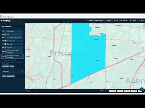
Excited to share a short walkthrough of NexaMap, my open-source GIS Map Viewer project.
:movie_camera: Watch the demo here:
NexaMap
This project is focused on building a lightweight, extensible, and developer-friendly desktop mapping experience using modern technologies.
🔎 In this demo, I showcase:
- Interactive map navigation
- Layer management
- Analysis capabilities
- Clean UI designed for extensibility
- Foundation for future AI-powered geospatial workflows
As someone who has spent decades in GIS, cloud, and data engineering, I strongly believe the future of mapping lies at the intersection of:
📍 Geospatial + 🤖 AI Agents + ☁️ Cloud-native architecture
This is just the beginning. I’ll be adding:
- AI-assisted spatial analysis
- Agent-driven workflows
- Real-time data integrations
- Enterprise-grade extensions
💡 If you're a GIS developer, data engineer, or AI enthusiast — I’d love your feedback and contributions.
GitHub repo:
vkondepati/gis-map-viewer: A lightweight, interactive GIS + Graph-based map viewer for spatial explo...
Let’s build intelligent geospatial systems together.
hashtag#GIS hashtag#OpenSource hashtag#GeoSpatial hashtag#AI hashtag#AgenticAI hashtag#DataEngineering hashtag#CloudComputing hashtag#NexaMap hashtag#Innovation
Venkat
Follow me on: LinkedIn
If this response helps or is the solution to your post, please consider marking it as a solution
- Mark as New
- Bookmark
- Subscribe
- Mute
- Subscribe to RSS Feed
- Permalink
Venkat
Follow me on: LinkedIn
If this response helps or is the solution to your post, please consider marking it as a solution
- Mark as New
- Bookmark
- Subscribe
- Mute
- Subscribe to RSS Feed
- Permalink
Hi ESRI Community 👋
I wanted to share recent progress on **NexaMap**, an open-source GIS platform I’ve been building with a strong focus on:
🌍 Accessible GIS education
🗺️ Offline-first workflows
☁️ Modern cloud-native spatial analytics
🤖 AI-ready geospatial architecture
The project is especially aimed at helping students, researchers, and developers in low-bandwidth or underserved environments learn and work with GIS completely free.
# :new_button: Recent Features & Improvements
## 🗺️ Interactive GIS Experience
* Improved map rendering
* Layer & data management
* Feature inspection tools
* Editing workflows
* Thematic visualization support
## :bar_chart: Spatial Analysis Enhancements
* Buffer analysis
* Distance calculations
* Spatial overlays
* Geometry editing
* CRS & projection handling
## :open_file_folder: Expanded Data Support
Support for:
* GeoJSON
* Shapefile
* KML
* GeoPackage
* CSV
* WMS/WFS/WMTS services
## ☁️ Modern Data Platform Integrations
One area I’m especially excited about is integrating GIS with modern data ecosystems:
* DuckDB
* Snowflake
* Databricks
* Apache Iceberg
The goal is to reduce data movement and enable modern spatial analytics workflows directly within GIS environments.
## 🤖 GeoAI & Future Direction
I’m also exploring:
* AI-assisted GIS workflows
* Natural language spatial querying
* Agentic GIS systems
* Offline AI possibilities
* Educational GeoAI tooling
# :graduation_cap: Educational Vision
A core motivation behind NexaMap is making GIS more accessible to students worldwide.
Many learners still face barriers such as:
* Expensive software
* Internet dependency
* Hardware limitations
NexaMap aims to provide:
✔️ Free GIS learning
✔️ Offline capability
✔️ Lightweight architecture
✔️ Real-world spatial workflows
✔️ Open-source extensibility
# 🌍 Looking for Feedback & Collaboration
I’d love input from the ESRI community on:
* GIS architecture ideas
* GeoAI workflows
* Educational GIS use cases
* Spatial analysis features
* Performance optimization
* Open-source collaboration
🔗 GitHub:
https://github.com/vkondepati/gis-map-viewer
:movie_camera: Demo:
https://www.youtube.com/watch?v=xeQJm8oYbys
Would love to hear your thoughts and suggestions from fellow GIS professionals and developers. 🚀🌍
Venkat
Follow me on: LinkedIn
If this response helps or is the solution to your post, please consider marking it as a solution