- Home
- :
- All Communities
- :
- User Groups
- :
- New to GIS
- :
- Questions
- :
- Adjust Label or address text
- Subscribe to RSS Feed
- Mark Topic as New
- Mark Topic as Read
- Float this Topic for Current User
- Bookmark
- Subscribe
- Mute
- Printer Friendly Page
Adjust Label or address text
- Mark as New
- Bookmark
- Subscribe
- Mute
- Subscribe to RSS Feed
- Permalink
Hello
I am having trouble with adjusting the address text on our Main Map that is viewed through out our offices.
I tried to change the address in the attribute table but it will not let me.
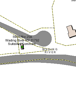
Please see attachment- I simply need to add a "A" after 25.
What am I missing?
I am using 10.6
Thank you
- Mark as New
- Bookmark
- Subscribe
- Mute
- Subscribe to RSS Feed
- Permalink
Can you provide some more details? There are a whole plethora of things that could be going on here:
- Is what is viewed labels or annotation? Both can be modfified, but the process is very different. Example: Labels and Annotation
- Or is it what is being viewed is actually a static map service?
- If it is annotation, is it Map Annotation or Feature Class Annotation?
- If it is labels, is it actively labelling off of a layer or is it currently just a free-standing graphic label?
- If it is actively being labelled off a layer, which layer is it (what is the name)?
- What type of dataset is that layer in? Feature Class in an Enterprise Geodatabase (SDE)? Feature Class in a File Geodatabase? Personal Geodatabase? Shapefile? Other?
- Is that layer editable?
- Is it potentially an issue that permissions have been set to prevent editing on what would otherwise be an editable layer?
Chris Donohue, GISP
- Mark as New
- Bookmark
- Subscribe
- Mute
- Subscribe to RSS Feed
- Permalink
Hello Chris-
Thanks for the help- I will answer the question to the best of my knowledge:
1) I believe they are labels
2) Not a static map- it is viewed by a ARCMAP viewer on intranet by town employees- layers switched on and off as per needs of person. I am updating the map from time to tim - learn as I go-
3) actively labelling off of a layer- i think
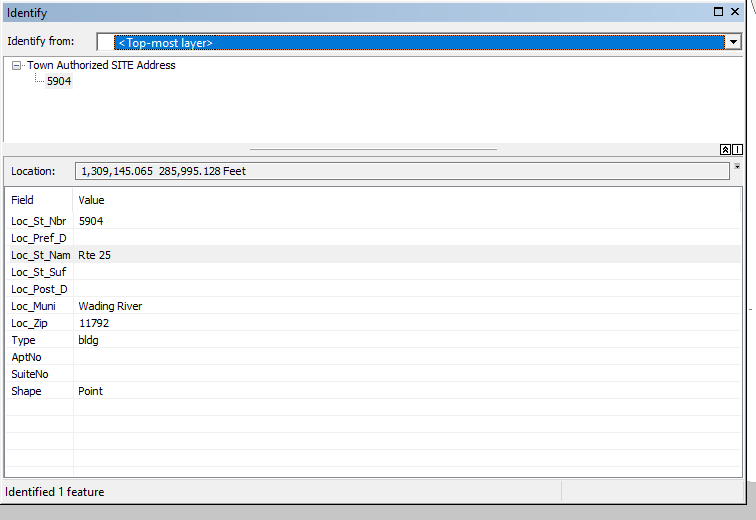
4) Town Authorized SITE address- see picture in original post- turn layer off- address disappears
5) Feature Class in an Enterprise Geodatabase (SDE)- ouw our SQL server
6) Is that layer editable? Yes
7) I have a standard concurrent license - I should be able to edit
- Mark as New
- Bookmark
- Subscribe
- Mute
- Subscribe to RSS Feed
- Permalink
Knowing the data is in an enterprise geodatabase helps limit the possibilities. Some specific things to check:
Do you know if the Enterprise Geodatabase is it set up to do Versioning? Versioning is a common way to allow editing; however that is not the only way. For example, some systems are set up to directly edit the data.
An overview of versioning—ArcGIS Help | ArcGIS Desktop
If it is set up to do Versioning, have you been able to make a Version of the Town Authorized SITE address to do the edits in? The reason I ask is sometimes users are assigned view permissions but not write permissions, i.e. without write permissions one cannot make a version nor edit the data. If that is the case, you will need to contact your enterprise database administrator and request privileges to be able to edit the data.
Creating versions and setting permissions—ArcGIS Help | ArcGIS Desktop
If editing a Version is not the approach you have tried so far to change the information, as the system is not set up to do Versioning, what approach did you use? You mentioned "I tried to change the address in the attribute table but it will not let me.", but what environment were you in when this was attempted? Did a warning message pop up when you tried to do editing? Or was it instead that when you tried to start an editing session it was grayed out? Can you elaborate on what was tried?
Chris Donohue, GISP
- Mark as New
- Bookmark
- Subscribe
- Mute
- Subscribe to RSS Feed
- Permalink

We don't do versioning here as I am pretty much the only one working on it.
So above in picture- I have started a edit session- right clicked on layer- that is highlighted in table of contents-
in the attribute table the highlighted row is where I think I would make a change to the should take place- but again I am not sure.
- Mark as New
- Bookmark
- Subscribe
- Mute
- Subscribe to RSS Feed
- Permalink
I assume the objective is to edit the Loc_St_Nam field. When you click on that field in box that has Rte 25 for the highlighted record that needs to be changed to Rte 25A, by any chance does a pulldown appear? It may be that Domains and Subtypes were applied to constrain the data entry. If so, use the pulldown to choose Rte 25A from the list (hopefully that is one of the choices).
There may also be a network permission issue going on. I've had that happen occasionally where the network gets flaky and suddenly the editing gets wonky in our enterprise geodatabase. Check with your network administrator to see if things are working correctly at the network level.
Another possibility - has anyone done the routine maintenance on the enterprise geodatabase recently? When our system gets wierd one of the first things checked is whether the routine maintenance has failed to run as scheduled (much of ours is scheduled script runs).
If none of these are the issue, you may need to get ESRI Support on the phone for assistance.
Chris Donohue, GISP
- Mark as New
- Bookmark
- Subscribe
- Mute
- Subscribe to RSS Feed
- Permalink
Thanks Chris- I narrowed it down to this I think-
I need to find how to get to the address point- then I and adjust as necessary-
How do I find the above?
Thanks
- Mark as New
- Bookmark
- Subscribe
- Mute
- Subscribe to RSS Feed
- Permalink
Hey Chris
Esri support solved the problem- the problem was that some of the files where versioned and some where not.
"During our call, it appeared that the feature that the edits were being attempted on were not registered as version and were also not selectable in the map document. In order to fix this we had accomplished two tasks. First, we had opened Editing options and unchecked "Edit a version of the database with the ability to undo and redo. Second, we had changed to layer in the map to selectable through the table of contents. This allowed us to update the necessary address field so changes reflected on the map."
Hope this can help someone else.
PB
- Mark as New
- Bookmark
- Subscribe
- Mute
- Subscribe to RSS Feed
- Permalink
Ah, so your system is set up to the more common approach of Versioning. Definitely good to know going forward.
Not to open up a can of worms, but as part of this realization are you theoretically now the SDE Administrator also? If so, I would recommend looking into the ongoing maintenance that is needed to keep SDE functional, as quite a few issues can crop up if the maintenance is not done. I'm not an SDE Administrator myself, so don't know the particulars, but have in the past seen quite a few issues that ended up being tracked to the maintenance being done (typically when scripts that do much of it fail to run). If you start a new post on that topic here on GeoNet, there are folks who can point you the right way. Also, ESRI Support can probably provide information on it.
http://proceedings.esri.com/library/userconf/proc17/tech-workshops/tw_605-474.pdf - see the Maintenance section.
Chris Donohue, GISP