- Home
- :
- All Communities
- :
- Products
- :
- ModelBuilder
- :
- ModelBuilder Questions
- :
- Does anyone know how to write a table with x,y val...
- Subscribe to RSS Feed
- Mark Topic as New
- Mark Topic as Read
- Float this Topic for Current User
- Bookmark
- Subscribe
- Mute
- Printer Friendly Page
Does anyone know how to write a table with x,y values to a feature class in model builder?
- Mark as New
- Bookmark
- Subscribe
- Mute
- Subscribe to RSS Feed
- Permalink
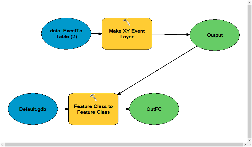
At the end of my model, I'd like to output a gdb feature class from an input gdb table containing the coordinates. The Make XY Event Layer (Data Management) does not seem to work in my model. I'm sure there's multiple ways to do this.
Solved! Go to Solution.
Accepted Solutions
- Mark as New
- Bookmark
- Subscribe
- Mute
- Subscribe to RSS Feed
- Permalink
The Event Layer is an in memory dataset. You just choose the Event Layer as an input to the Feature Class to Feature Class tool.
- Mark as New
- Bookmark
- Subscribe
- Mute
- Subscribe to RSS Feed
- Permalink
The Event Layer is an in memory dataset. You just choose the Event Layer as an input to the Feature Class to Feature Class tool.
- Mark as New
- Bookmark
- Subscribe
- Mute
- Subscribe to RSS Feed
- Permalink
Oh, I see. It seems so simple now. Just like a feature layer or a table view, it's stored temporarily in memory and has not yet been written to the drive. Thank you Rhett!
- Mark as New
- Bookmark
- Subscribe
- Mute
- Subscribe to RSS Feed
- Permalink
Just use Convert Coordinate Notation—Help | ArcGIS Desktop in the model builder. Use the appropriate coordinate_format.
Think Location
- Mark as New
- Bookmark
- Subscribe
- Mute
- Subscribe to RSS Feed
- Permalink
I had a feeling there were multiple methods. I totally spaced the event "layer" is in memory similar to table views and feature layers. I'll try out the Convert Notation Tool as well. Thanks for your help Jayanta!
- Mark as New
- Bookmark
- Subscribe
- Mute
- Subscribe to RSS Feed
- Permalink
Was not aware of this tool. Have some uses for it in the future. However, it appears as if this only supports a select few Coordinate systems?
I may be missing something, but I don't see a way to use this to convert a table in say State Plane to a Feature class in State Plane. Would be nice if I'm just missing something here and could do this in one step.
R_
- Mark as New
- Bookmark
- Subscribe
- Mute
- Subscribe to RSS Feed
- Permalink
No, this is a two step process. The Create Coordinate Notation tool is very handy for getting the XYs you need in the table if they are not in the proper format (for example, you have DDMMSS.ss data that you need to convert to geographic (lat/lon) x,y to create points). I remember putting in enhancement requests for such a tool for ARC/INFO back in the early 1990s, it's really useful that it finally showed up in ArcGIS!