- Home
- :
- All Communities
- :
- Products
- :
- Mapping
- :
- Mapping Questions
- :
- Re: Graticule of degrees decimal minutes
- Subscribe to RSS Feed
- Mark Topic as New
- Mark Topic as Read
- Float this Topic for Current User
- Bookmark
- Subscribe
- Mute
- Printer Friendly Page
Graticule of degrees decimal minutes
- Mark as New
- Bookmark
- Subscribe
- Mute
- Subscribe to RSS Feed
- Permalink
I'd like to display lat/long in decimal degrees or degrees decimal minutes in a grid/graticule on the map layout. Though the option exists in the properties, the apply button is inactive. Does anyone know how to make this work?
- Mark as New
- Bookmark
- Subscribe
- Mute
- Subscribe to RSS Feed
- Permalink
do you have defined coordinate systems for all the files? What is the data frame coordinate system.
- Mark as New
- Bookmark
- Subscribe
- Mute
- Subscribe to RSS Feed
- Permalink
The data frame coordinate system is WGS 1984. I have one feature class in this map with a NAD83 Albers projection. On the Intervals tab of the properties once the grid is created, the option exists to choose decimal degrees or degrees and decimal minutes yet the apply button is inactive.
Changing the origin to Use origin from the current coordinate system activates the apply button yet the grid does not change from Degrees- minutes-seconds even with a refresh.
So now I've stumbled into the Labels tab. Additional properties allows a choice for Label type. The Label Style Format only gives a choice of DMS.
I've now successfully lost the minutes and seconds and have not gained decimal anything.
Any insight would be appreciated.
- Mark as New
- Bookmark
- Subscribe
- Mute
- Subscribe to RSS Feed
- Permalink
And what are the display units of the data frame? they can be set to what you want, perhaps that will allow for alternate settings for degrees. of course that first link i sent describes the 3 options for creating them, perhaps one is better than the others, you could try
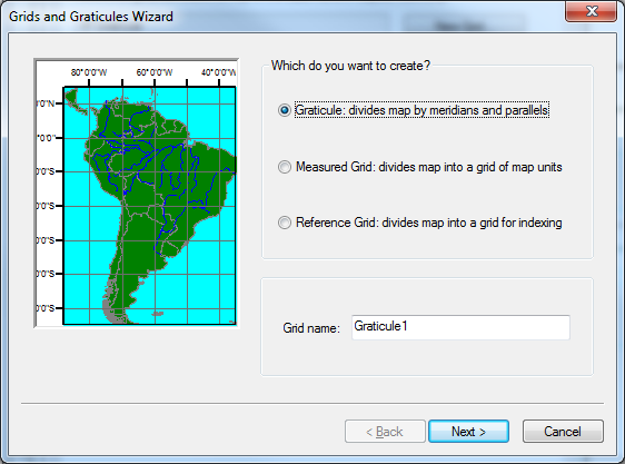
A quick tour of data frame grids and the Grids and Graticules Wizard—Help | ArcGIS for Desktop
- Mark as New
- Bookmark
- Subscribe
- Mute
- Subscribe to RSS Feed
- Permalink
On the labels tab of the grid properties, there is a button for additional properties.
At the top there is a pulldown.
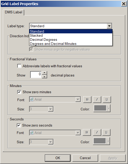
Does this not fix your problem?
- Mark as New
- Bookmark
- Subscribe
- Mute
- Subscribe to RSS Feed
- Permalink
I've tried this without success. Will give it another go tomorrow as I've got to get other work done today. Thanks for the response.
- Mark as New
- Bookmark
- Subscribe
- Mute
- Subscribe to RSS Feed
- Permalink
In that scenario (using the Additional Properties button and setting it to use decimal degrees or degrees and decimal minutes) you will also need to set the number of decimals to be greater than zero. And even then it drops trailing zeros.
- Mark as New
- Bookmark
- Subscribe
- Mute
- Subscribe to RSS Feed
- Permalink
Can you elaborate on how using the default values for a graticule (under data frame properties->Grids->New Grid...) doesn't work?
- Mark as New
- Bookmark
- Subscribe
- Mute
- Subscribe to RSS Feed
- Permalink
Using default values works fine. It displays in Degrees, Minutes, seconds. I'd like to display coordinates in decimal degrees and am struggling to do so.
- Mark as New
- Bookmark
- Subscribe
- Mute
- Subscribe to RSS Feed
- Permalink
I would have guessed that you could change a graticule to DD, but it doesn't appear so. In that case, you can create a measured grid (second option in my image above) using WGS84 as the coordinate reference system. Then, if it's not already the default unit, change to DD in grid properties -> intervals tab.
edit: just saw Neil's answer re: graticule label styles, which appears to work, although I could not force it to show decimal places for whole numbers (e.g. 122 vs. 122.00000). If that's not an issue for you, then that should also work. There seems to be more flexibility through grids, however.