- Home
- :
- All Communities
- :
- Products
- :
- Mapping
- :
- Mapping Questions
- :
- coordinatesystems - position of shape files
- Subscribe to RSS Feed
- Mark Topic as New
- Mark Topic as Read
- Float this Topic for Current User
- Bookmark
- Subscribe
- Mute
- Printer Friendly Page
- Mark as New
- Bookmark
- Subscribe
- Mute
- Subscribe to RSS Feed
- Permalink
Dear Community,
Sorry in advance for my English. I’ve got following issue:
I’ve imported AutoCAD data in ArcMap and have assigned the projection it is drawn in the CAD file – MGI Gauß-Krüger East.
Therefore the automatically calculated shape area conforms completely accurate with the measured areas from CAD data. The problem ist that the produced shape file is not in the right position it should be (see attached image) if its projected in MGI GK East.
If I transform the projection – for example to GCS WGS 1984 or WGS 1984 UTM 33N – the shape file is in correct position, but the shape area logically does not conform to the area form CAD data.
The problem seems to be, that MGI does not harmonize with any other coordinate system or projections. If I transform any shape file with different projections than MGI to MGI, the shape files accord to my data imported from CAD. But if I try to display my imported data along with shape files of other projections (in ArcMap, ArcGIS Explorer) the imported data is not in correct position.
For me the exact shape area as measured in CAD is important – as well as the correct position along with other spatial data.
I hope I made my problem clear and somebody can help me. Thank you for your time!
Solved! Go to Solution.
Accepted Solutions
- Mark as New
- Bookmark
- Subscribe
- Mute
- Subscribe to RSS Feed
- Permalink
Mattias,
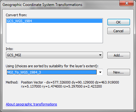
It looks like you're not setting a geographic/datum transformation. Try setting MGI_To_WGS_1984_3.
Melita
- Mark as New
- Bookmark
- Subscribe
- Mute
- Subscribe to RSS Feed
- Permalink
Mattias,
It looks like you're not setting a geographic/datum transformation. Try setting MGI_To_WGS_1984_3.
Melita
- Mark as New
- Bookmark
- Subscribe
- Mute
- Subscribe to RSS Feed
- Permalink
Thx a lot Melita, that solves the problem completely! 